Weather Whirlwind: Amy Freeze’s Guide to Southeast’s Swirling Skies
By
Amy Freeze
From tempests in Tennessee to calm currents in Carolina, join Amy Freeze as she navigates through the shifts and swirls of the Southeast's weather.
Meteorologist Amy Freeze brings you the latest updates on the dynamic weather conditions in the Southeast. Stay tuned for more detailed insights!
Join Amy Freeze as she covers the evolving weather patterns across the Southeast. From Miami’s pleasant afternoons to notable storm fronts moving through major cities, Amy provides a comprehensive look at what to expect. With temperatures and storm activities detailed, this update is your go-to guide to staying prepared and informed.
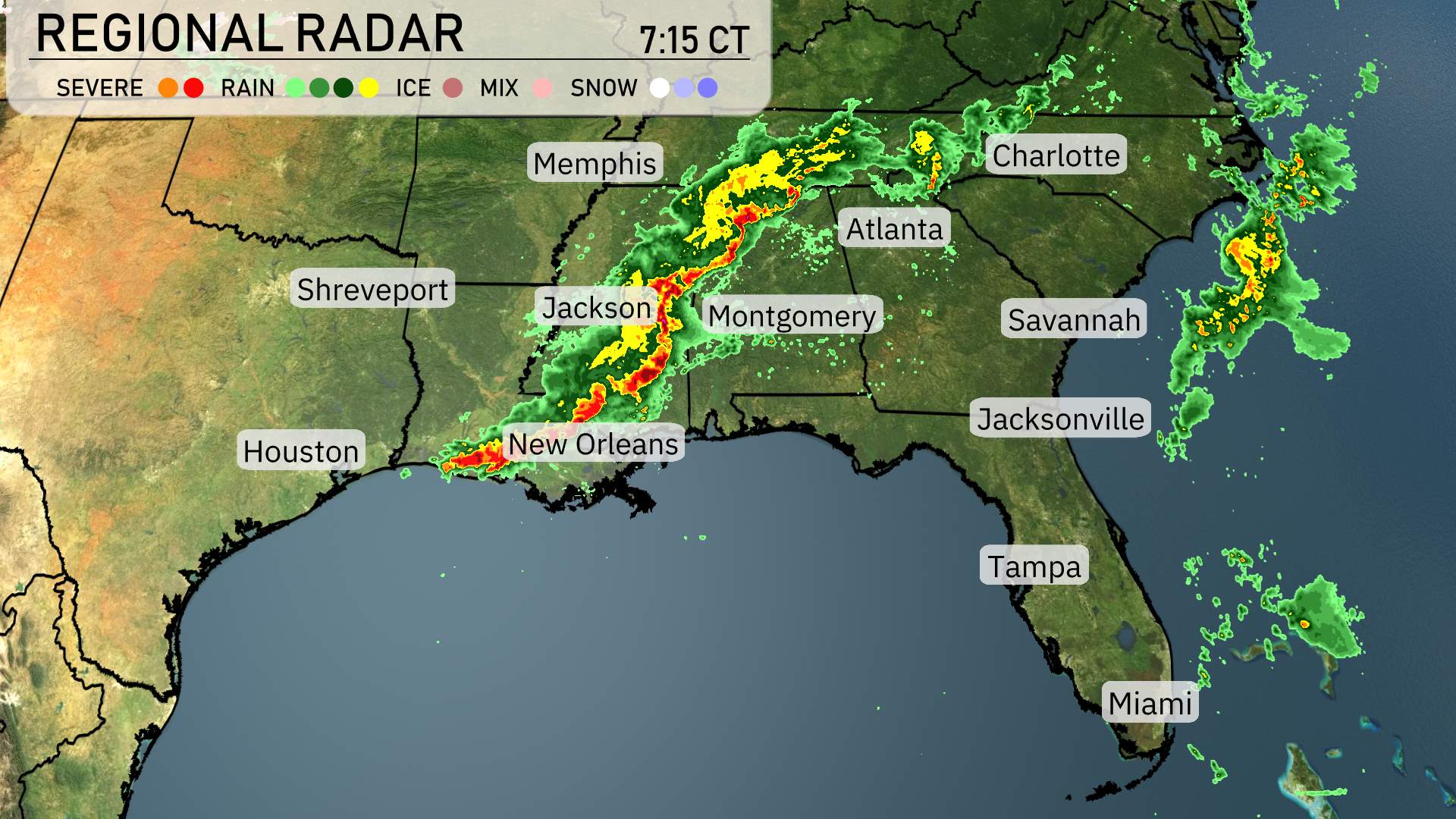
On the Regional Radar, a strong line of storms is moving from west to east across the Southeast. These severe storms are currently sweeping through Jackson, heading northeast toward Atlanta. Shreveport is experiencing significant storm activity as this line moves through, with New Orleans also under the threat of severe weather. As you look farther north, Memphis is starting to see the approach of these storms, and they will eventually make their way into western parts of the Tennessee River Valley.
In Georgia, rain is intensifying and moving toward the Carolinas, with Atlanta soon to be affected. Montgomery is bracing for heavy rain and potential storms from this advancing system. The coastal areas are somewhat sheltered at the moment, with Savannah and Charleston enjoying a break from the rainfall.
Over in Florida, Jacksonville is currently experiencing showers, but skies should begin to clear as the day progresses.
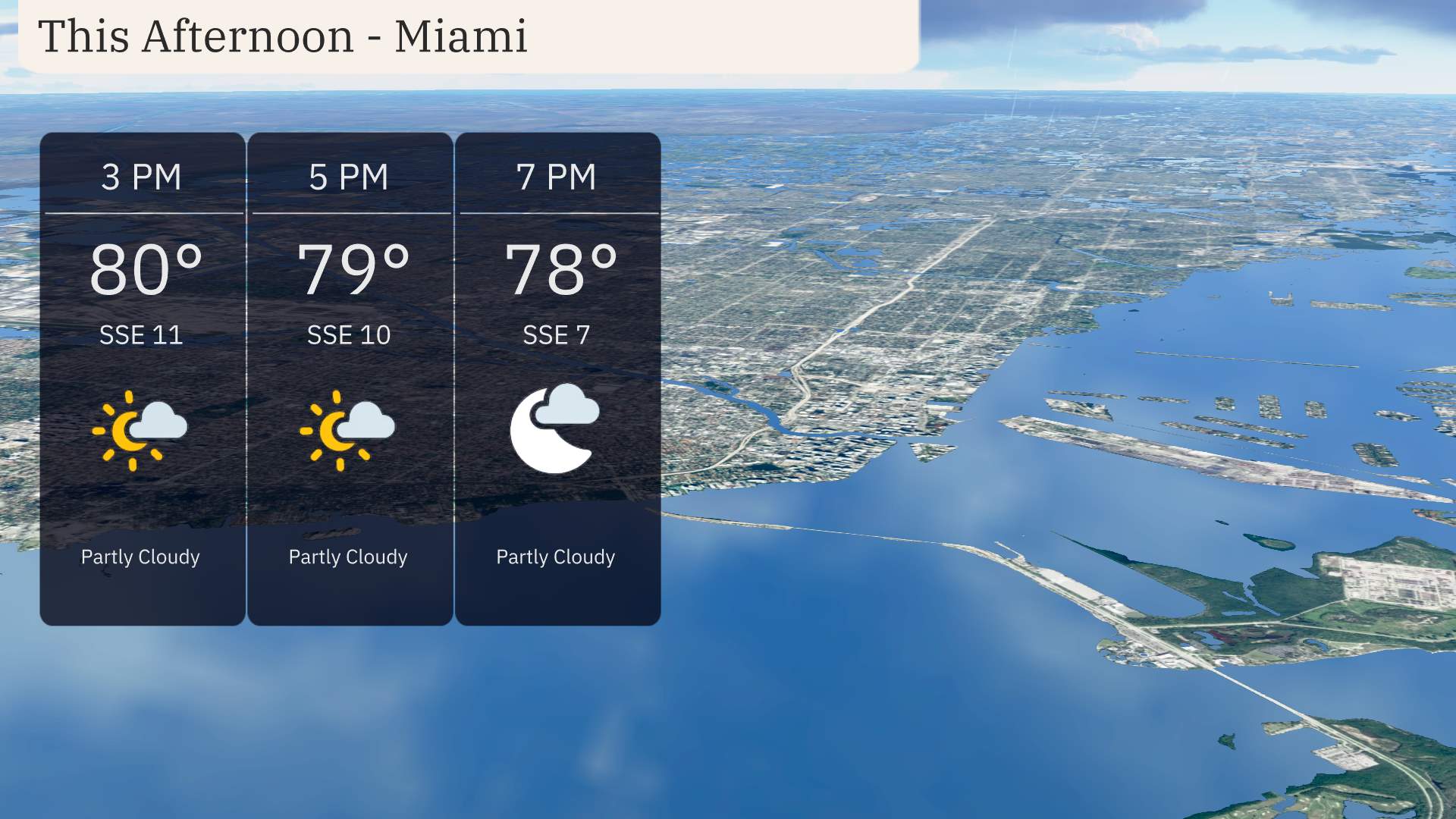
Miami’s afternoon forecast calls for temperatures starting at 80 degrees at 3 p.m., gradually easing to 78 degrees by 7 p.m. Expect partly cloudy skies with a steady southeast breeze at 11 miles per hour at 3 p.m., calming to 7 miles per hour by 7 p.m.
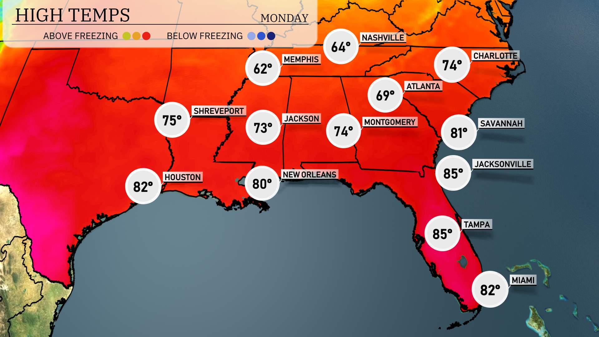
Today’s regional high temperatures in the Southeast are looking warm and inviting. In New Orleans, we’re reaching a high of 80 degrees, while steering eastward to Jackson, expect a pleasant 73 degrees. Atlanta is enjoying a comfortable 69 degrees, and Montgomery is slightly warmer with a high of 74 degrees.
Jacksonville and Tampa are tying at a toasty 85 degrees. Meanwhile, Savannah edges just a bit cooler at 81 degrees.
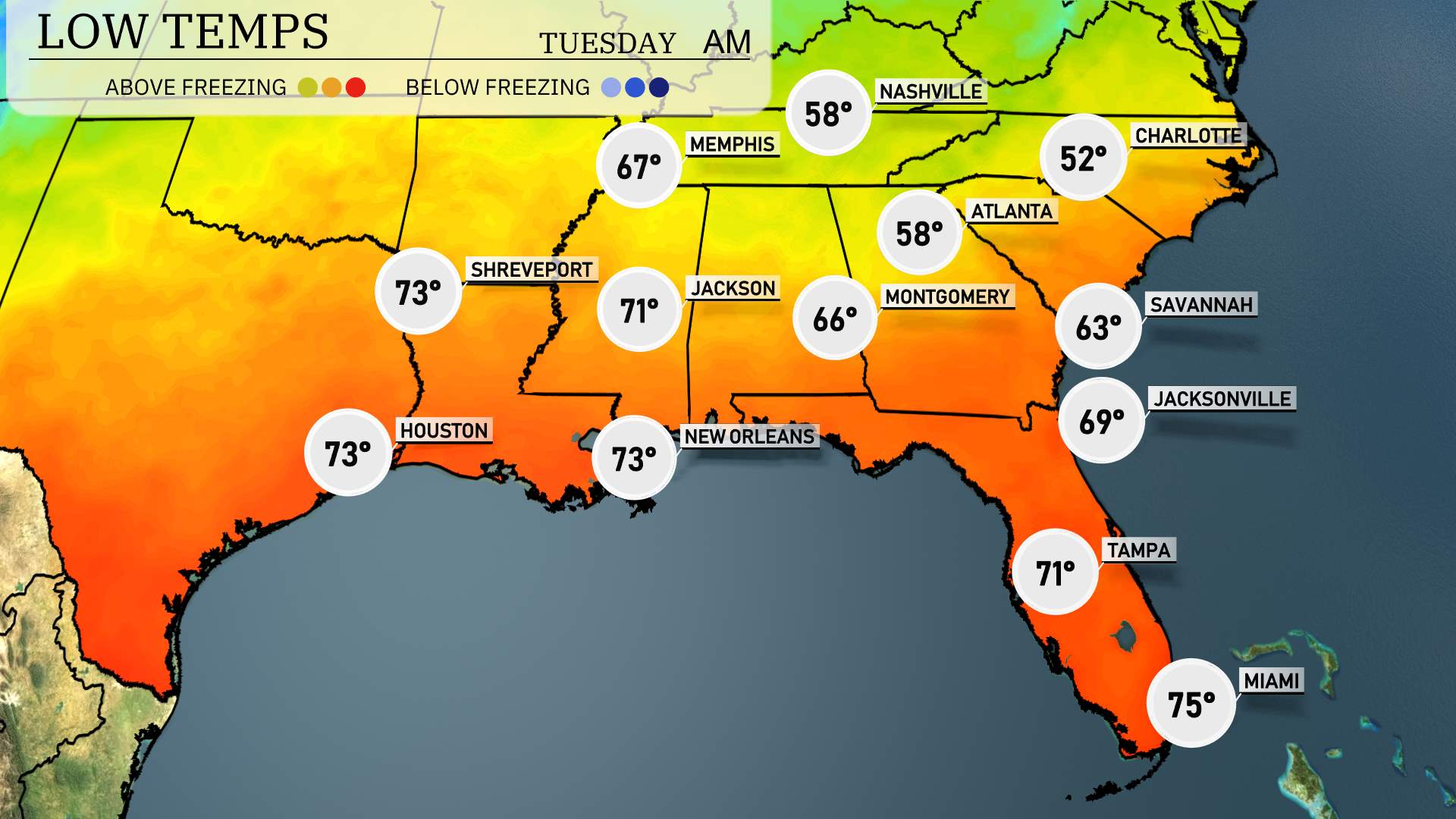
Tonight, the Southeast region is gearing up for some notably cool temperatures. In Nashville, expect a low of 58 degrees—a crisp night ahead. Memphis will be just a degree cooler at 57. Heading down to Atlanta, temperatures will dip to 58 as well, while Montgomery will see a low of 66.
Jackson will be a bit warmer at 71 degrees, followed closely by Shreveport at 67 degrees. New Orleans maintains a warm 73, while Houston stays mild with a low of 73 degrees. Down in the Sunshine State, Tampa will cool down to 71.
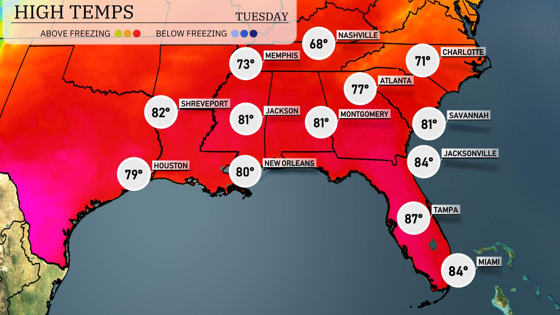
High temperatures in the Southeast tomorrow are looking warm as a potent ridge of high pressure dominates the area.
In New Orleans, expect a high of 80 degrees, while Jackson will see slightly warmer conditions, reaching 81 degrees. Atlanta is on track for a high of 77 degrees, aligning with seasonal norms. Montgomery follows closely behind with a warm high of 81 degrees.
Tampa is forecasted to hit a toasty 87 degrees, a notable above-average reading for this time of year. Jacksonville will also enjoy a pleasant 84 degrees.
Memphis will reach just 73 degrees, with Nashville coming in at a cooler 68 degrees.
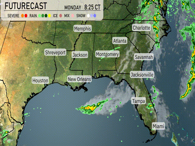
A cold front is expected to sweep through the Southeast, triggering scattered thunderstorms from Houston through New Orleans and into the Florida Panhandle by midafternoon tomorrow. Be prepared for heavy rain and potential strong winds, especially across parts of Mississippi and Alabama. Coastal regions, including Tampa and Jacksonville, may see brief periods of heavy rain and isolated thunderstorms in the late afternoon. Temperatures will remain mild. Keep an eye out for any severe weather warnings due to the possibility of rapidly developing storms. As the front moves farther east, expect decreasing storm activity with drier conditions emerging by Tuesday evening across Georgia and the Carolinas.
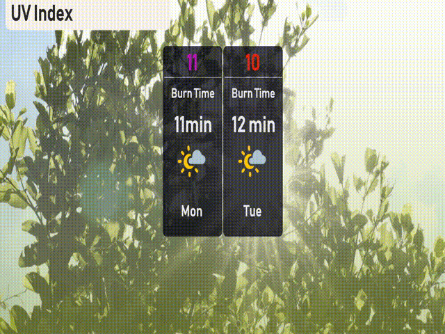
The UV index in Miami will soar to an extreme level of 11 on Monday, with an expected burn time of just 11 minutes. Make sure to take precautions by wearing sunscreen.