Navigating the Storm: This Week’s Weather Patterns Across the Southeast
By
Amy Freeze
Dive into an in-depth analysis of the fluctuating weather trends from Miami to Memphis. Expect everything from balmy sunshine to stormy afternoons!
Meteorologist Amy Freeze covers this week’s weather patterns across the Southeast – from storm watches in Memphis to sun-kissed skies in Miami.
This comprehensive update takes you through a rollercoaster of weather experiences across the Southeast. Learn how weather patterns transition from thunderous downpours to soothing sunny days, and what that means for your local activities and safety precautions. Plus, get a detailed 7-day forecast for Miami! Don’t forget the sunscreen with a UV index hitting a high 10! Stay prepared and informed with insights from Amy Freeze.
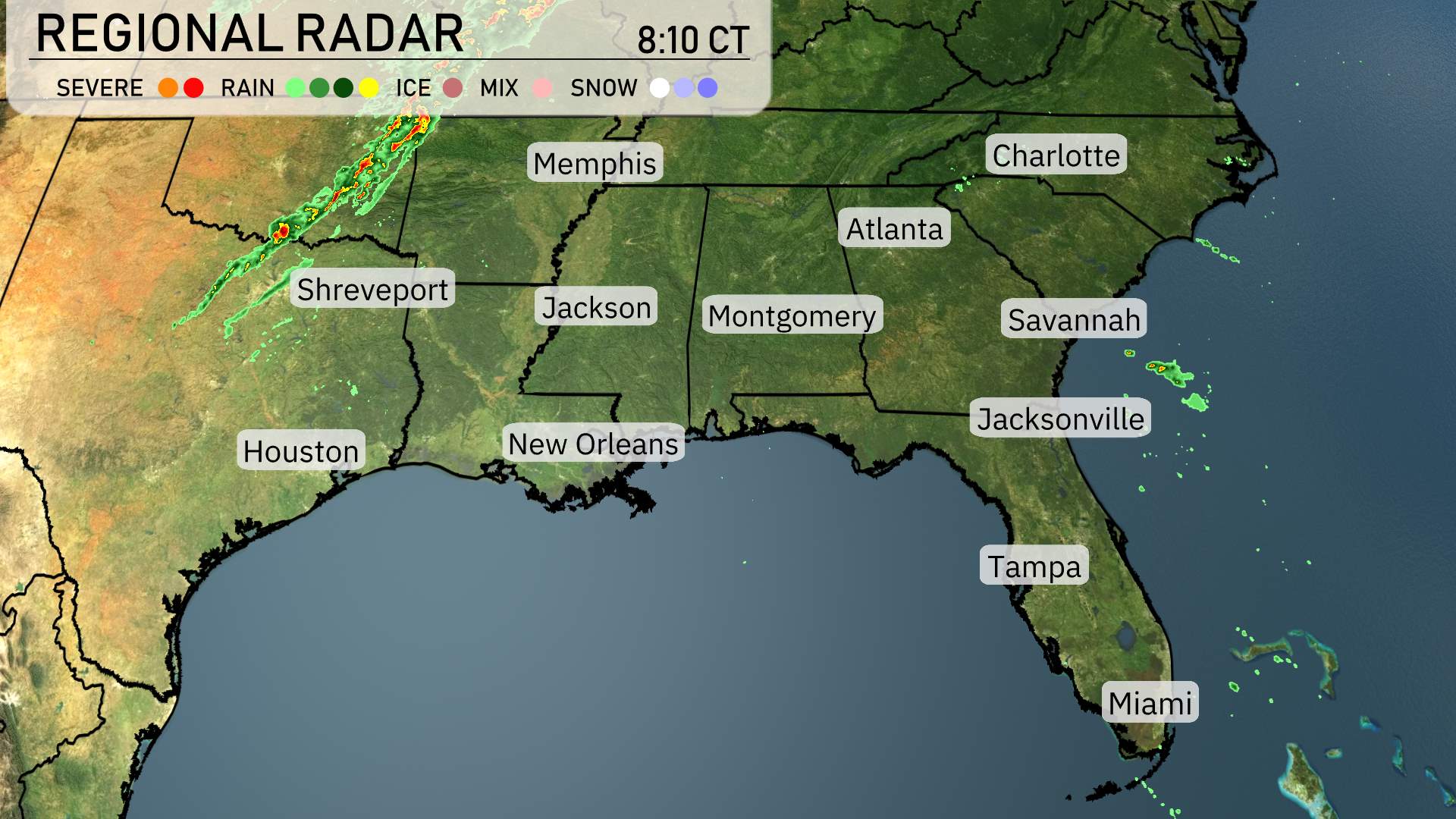
The Southeast is experiencing some dynamic weather patterns today. Memphis and the Tennessee River Valley are under a watchful eye as thunderstorms could make their presence felt there today. On the radar, a line of severe storms is advancing from eastern Texas towards Louisiana, impacting areas like Shreveport with strong thunderstorms. Showers are proceeding northeast, with Jackson experiencing consistent, heavy rainfall as they head towards Atlanta. Meanwhile, in Georgia and moving into the Carolinas, clouds are on the increase, heralding the upcoming rainstorms. However, the coastal cities of Savannah and Charleston are currently enjoying a reprieve from precipitation. Jacksonville is seeing scattered showers, but skies are clearing out as you move northward into Florida.
Miami this afternoon is experiencing partly cloudy skies with temperatures easing from 81 degrees at 3 PM to 78 degrees by 7 PM. Winds are steady from the east southeast transitioning to east at around 15 to 16 miles per hour.
Let’s take a look at today’s high temperatures across the Southeast. In Jackson, we’re warming up nicely with a high of 87 degrees. Meanwhile, New Orleans is heating up to 84 degrees. Over in Montgomery, it’s a warm day with the temperature hitting 90 degrees.
Checking in on the Florida coast, Jacksonville is quite balmy at 88 degrees, while Tampa sets the bar higher with a sizzling 92 degrees. On the other hand, folks in Atlanta can expect a more mild afternoon with a high of 74 degrees. Savannah joins them at 79 degrees, creating a nice contrast with the warmer coastal cities.
Tonight, the Southeast will experience a noticeable drop in temperatures as colder air sweeps across the region. In Memphis, expect a low of 39 degrees, while Nashville will see a chilly 38. Shreveport will cool down to 47. Jackson will record a low of 45 degrees, with Montgomery dropping to 48. Atlanta will feel the chill as temperatures reach 44 degrees.
Tomorrow, the Southeast is gearing up for a warm and sunny day with many locations reaching above-average highs. Key cities are expecting quite a warmup.
In Jackson, Mississippi, the high will soar to 88 degrees, aligning with the region’s warmth. To the southwest, New Orleans will see a pleasant 85 degrees. Montgomery is expected to reach 89 degrees, making it one of the hottest spots. Atlanta will enjoy a high of 86 degrees, while further down the coast, Jacksonville, Florida, is forecasted to hit 88 degrees.
Meanwhile, Tampa is in for a steamy 93 degrees, indicating a significant shift toward summer-like temperatures. In contrast, farther north in Memphis, highs will be more moderate at around 70 degrees.
A cold front is sweeping through the Southeast tomorrow, bringing thunderstorms from Shreveport to Memphis early in the day. As this front progresses, expect intense thunderstorms with potential for heavy rain and gusty winds across Mississippi and Alabama by the afternoon. The Storm Prediction Center has highlighted parts of this region as being at risk for severe weather, so stay alert for warnings. Later in the evening, this system advances into Georgia, impacting areas from Atlanta to Savannah with rain showers and storms through Wednesday night. Temperatures will dip slightly after the front passes, but conditions should clear up as we move toward the latter part of the week.
The UV index in Miami is set to be very high at 10 on both Wednesday and Thursday, with a burn time of approximately 12 minutes in direct sunlight.