Navigating Through Nature’s Nuances: All Eyes on the Southeast’s Weather
By
Amy Freeze
Stay ahead with Amy Freeze’s detailed forecast of looming storms, cooler nights, and localized flood risks across the Southeast. Dive into regional weather patterns and prepare for the week ahead.
Discover the latest weather dynamics in the Southeast with Amy Freeze! From storm warnings to chilly forecast insights, keep up-to-date with comprehensive updates and prepare adequately for the week ahead.
Welcome to your essential weather guide with Amy Freeze. As tumultuous weather looms across the Southeast, from severe thunderstorms to significant temperature shifts, staying informed has never been more crucial. Track the advance of these systems, understand the challenges they might pose, and arm yourself with knowledge directly from a seasoned meteorologist. Keep tabs on changing weather patterns that affect Atlanta and beyond, including potential for localized flooding and crucial temperature alerts.
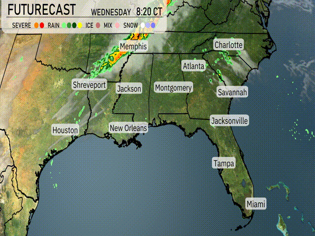
As we look at the Southeast, a line of storms is advancing west to east, stretching from Shreveport to Jackson, creating heavy thunderstorms. This storm line is specifically impacting areas around Jackson and is forecasted to keep pushing northeast toward Memphis and eventually reach Atlanta. On the Gulf Coast, there are some scattered showers hanging around eastern Louisiana and the vicinity of New Orleans, gradually moving inland.
In Georgia, the rain is not far off, moving in from Alabama and approaching the Carolinas. Clouds are thickening in its wake. However, coastal areas such as Savannah and Charleston are currently enjoying drier weather with clear skies. Over in Florida, Jacksonville is experiencing some lingering showers, but these will clear up soon, leading to brighter conditions farther south in Tampa and Miami.
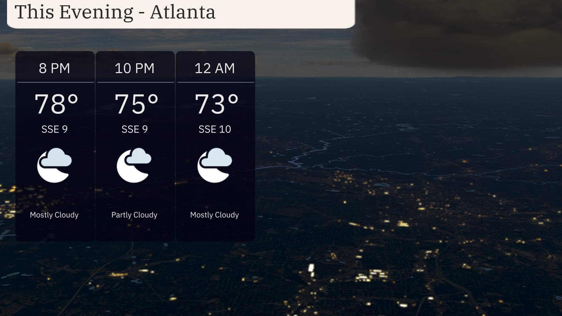
For this evening in Atlanta, expect mostly cloudy skies with temperatures beginning at 78 degrees at 8 PM, then easing down to 75 degrees by 10 PM. The wind will glide in a gentle south-southeast direction around 9 to 10 miles per hour. As the night progresses toward midnight, temperatures slightly decrease to 73 degrees under mostly cloudy conditions.
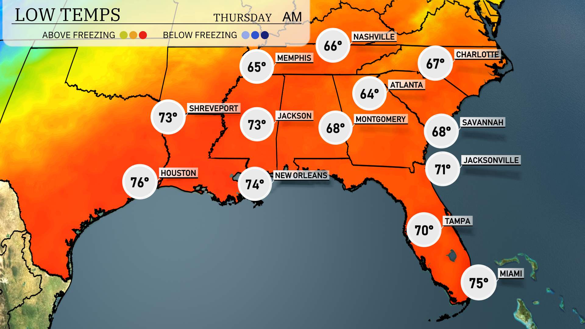
Tonight in the Southeast, temperatures dip significantly across the region. Nashville will drop to 32 degrees, a chilly forecast that might catch residents off guard. Memphis is looking at a low of 31 degrees, another night near freezing. In Atlanta, temperatures will fall to around 36 degrees, while Montgomery is set to see a low of 34 degrees. Further south, Jacksonville will be more mild with a low of 52 degrees, while Tampa will rest at 56 degrees.
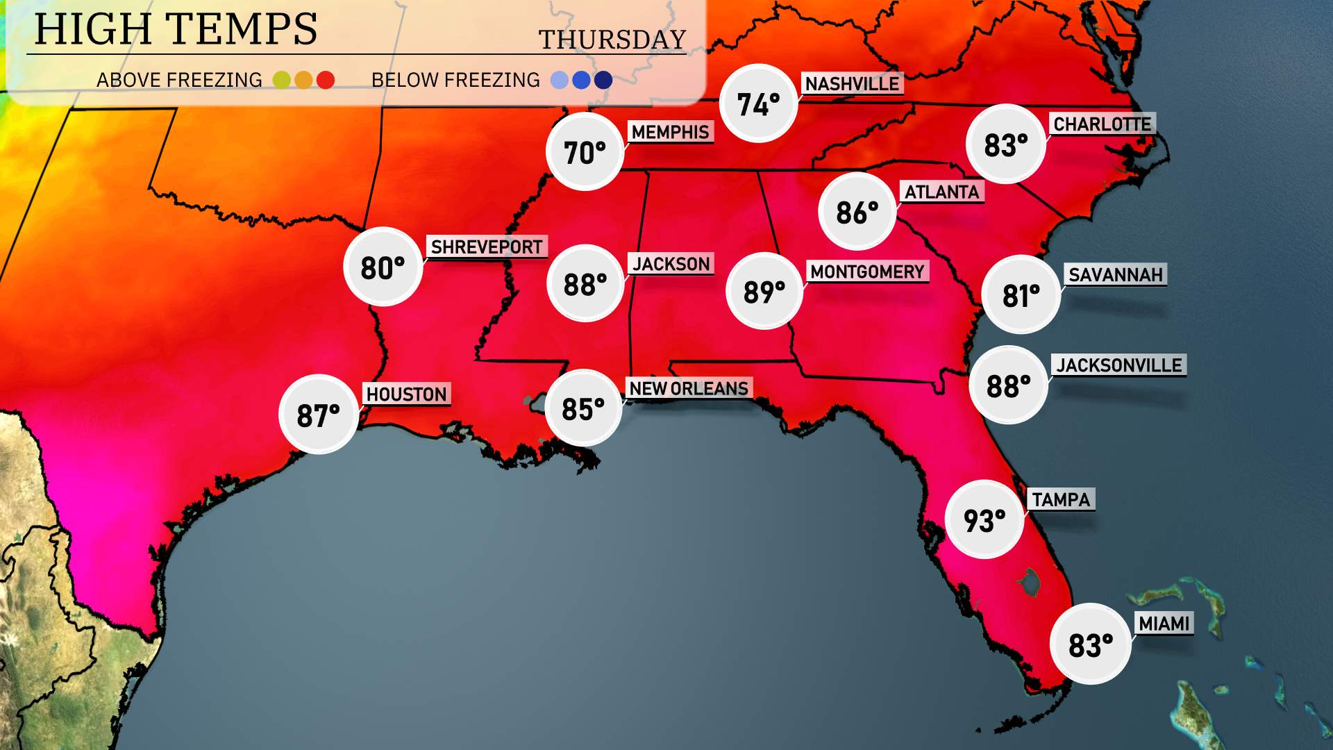
Starting off in the Gulf Coast, New Orleans will see a high of 85 degrees, while just to the east, Jackson hits 88 degrees. Montgomery also enjoys a warm day, reaching 89 degrees, showcasing above-average temperatures for this time of year.
Moving eastward, Atlanta can expect a high of 86 degrees, significantly above average, as warm, moist air filters in. Further down to Florida, Jacksonville has a high of 88 degrees, with temperatures in Tampa reaching a sizzling 93 degrees, likely influenced by the ongoing warm front.
In contrast, Memphis will see a cooler high of 70 degrees as it remains under cloud cover.
All eyes are on the tornado threats and severe weather chances into tomorrow. The risk of flash flooding continues through Sunday. A frontal system is making its way across the Southeast, setting the stage for an active weather scenario. The front stalls and there is a lot of moisture moving in from the Gulf so any thunderstorm that does develop could dump a lot of rain. Jacksonville gets rain by mid-morning Thursday, with showers advancing towards Savannah by afternoon. Over the next 48 hours, the region could experience over an inch of rain, raising potential for localized flooding. Keep a close watch on weather alerts from the Storm Prediction Center.
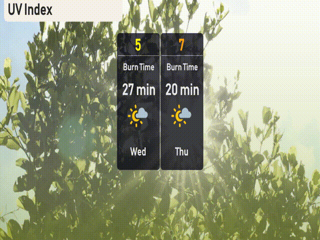
The UV index in Atlanta is a bit higher this week. On Wednesday, expect a moderate UV index of 5, which means about 27 minutes of sun exposure before potential burns. However, by Thursday, it’s set to rise to a high of 7, reducing burn time to just 20 minutes.
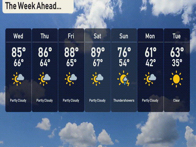
For the 7-day outlook in Atlanta:
Wednesday: Look forward to a sunny day with a high of 85 degrees and a low of 66.
Thursday: The sunshine continues, with temperatures warming up to 86 degrees and dipping to 64 at night.
Friday: Partly cloudy skies will prevail, with a daytime high of 88 degrees and a nighttime low of 65.
Saturday: Another partly cloudy day, reaching a warm 89 degrees during the day and 67 at night.
Sunday: Thunderstorms may roll in, cooling things down with a high of 76 degrees and a low of 54.
Monday: Partly cloudy and cooler, expect highs around 61 degrees with a crisp overnight low of 42.
Tuesday: Clear skies return, bringing a high of 63 degrees and a chilly low of 35.