April Showers and More: Southeast Weather Watch with Amy Freeze
By
Amy Freeze
From thunderstorms to sunshine, get the scoop on Southeast weather for April 4th, 2025, with expert insights from your favorite meteorologist Amy Freeze.
Discover what’s brewing in the Southeast weather for April 4th, 2025! Join Amy Freeze for an in-depth analysis of the day’s weather, from storm warnings to sunny highs. Stay prepared with her professional insights.
Hello, Atlanta and all across the Southeast! Meteorologist Amy Freeze here with your detailed weather coverage for April 4th, 2025. The region sees a mix of partly cloudy skies, severe storms, and sunny breaks today. While cities like Shreveport brace for impactful weather, places like Tampa enjoy warmer temperatures. Follow along as we dive into predictions, temperature sweeps, and essential safety tips amidst fluctuating weather conditions. Remember, whether it’s stormy or sunny, staying informed is your best defense against unpredictable weather. Check out more on our blog at https://amyfreeze.ai/
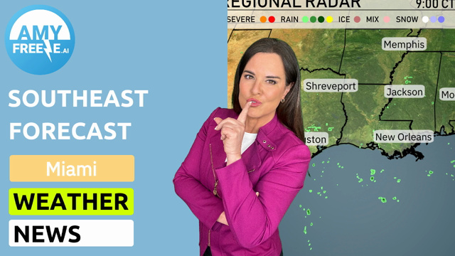
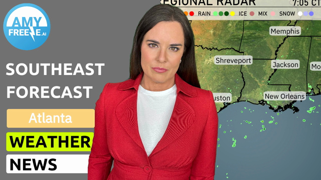
The Southeast region is experiencing a dynamic weather day. A line of severe storms is moving into the region from the west, impacting Memphis with heavy rain and potential thunderstorms. This line is tracking towards Shreveport, indicating that some severe weather is possible here as well. Meanwhile, to the east, Atlanta is seeing increasing cloud cover as showers approach from the west, promising rain later in the day. Over in Jacksonville, showers are light, contributing to slightly overcast conditions, but skies are expected to clear. Coastal areas such as Savannah and Charleston are currently enjoying clearer conditions, offering a brief respite from the rain. Farther south, Miami and Tampa are primarily dry, although some on-and-off showers might occur later. In the west, New Orleans and Houston are experiencing calm conditions with no significant precipitation at this time.
Temperatures in Atlanta for the afternoon reach up to 84 degrees with a consistent south wind at 10 miles per hour. Cloud cover prevails, keeping skies mostly overcast. By 7 PM, temperatures ease slightly to 81 degrees as clouds begin to part, allowing for brief sun breaks.
Let’s take a look at today’s regional high temperatures across the Southeast. In New Orleans, it’s feeling quite warm with a high reaching 90 degrees. Over in Jackson, temperatures are close behind at 88 degrees. Houston and Shreveport are enjoying a pleasant day with highs of 86. Montgomery is also warm at 86 degrees.
Moving to Florida, Jacksonville hits a high of 88, while Tampa experiences a notably warmer day at 93 degrees. In contrast, Savannah has a milder afternoon with a high of only 81.
In the Southeast, the temperatures are dropping quite noticeably. In Memphis, expect a chilly low of 48 degrees. Nashville cools down to 52, while Atlanta sees a low of 56. Over in Jackson, temperatures will dip to 59, and Shreveport will have a low of 50. Montgomery will stay relatively mild at 70 degrees. Farther south, New Orleans has a low of 72, while Tampa and Jacksonville will both sit at 70. Miami rounds out the region with a warmer low of 75 degrees.
High temperatures for Saturday are shaping up to be notably warm across the Southeast, with several cities experiencing above-average readings.
In Atlanta, look for a high of 86 degrees, while Montgomery will see a scorching 88 degrees. Over in Jackson, temperatures will reach 84 degrees, and New Orleans isn’t far behind with a high of 86 degrees.
Meanwhile, Florida leads the way with Jacksonville hitting 90 degrees and Tampa soaring to 91 degrees. Charleston will also feel the heat, expecting a high of 86 degrees.
These warmer temperatures can be attributed to a consistent push of warm, humid air across the region.
A cold front approaches from the west, impacting the Southeast tomorrow. Expect strong thunderstorms and heavy rainfall in areas from Shreveport to Jackson, leading to potentially impactful weather during the evening. The line of storms broadly affects regions stretching from Houston to New Orleans. As the front advances east, there’s a risk of flash flooding due to intense downpours in Montgomery and Atlanta into Wednesday morning. After the storm passes, temperatures cool down, providing a more mild atmosphere. Prepare for changing conditions and stay updated on potential weather warnings over the next two days.
The UV index in Atlanta reaches a moderate level of 6 on Friday, with a burn time of 23 minutes. By Saturday, it climbs to a very high level of 8, significantly reducing burn time to 17 minutes in direct sunlight.