Southeast Weather Watch: Evening Report & Weekly Outlook with Amy Freeze
By
Amy Freeze
Catch up on the latest weather updates with Amy Freeze, covering part cloudy skies, potential thunderstorms, and temperature insights across the Southeast.
From clear skies to looming storms, Meteorologist Amy Freeze breaks down what weather to expect in the Southeast this week.
Experiencing a calm yet dynamic weather landscape, the Southeast prepares for varied nightly temperatures as a cold front approaches, potentially stirring thunderstorms. Don’t miss out on daily forecasts and safety tips from your trusted meteorologist, Amy Freeze. Detailed insights include evolving skies in Atlanta, significant temperature shifts, and the anticipated storm risks from Mississippi to Georgia. Monitor the UV index, protect your skin, and prepare for potential rain.
A band of rain showers is making its way across the Southeast, stretching from west of Houston towards the regions near Shreveport and Jackson. Memphis is under the influence of light rain, and these showers are expected to move towards Atlanta. The coastal cities of Savannah and Charleston are dry, but cloud cover is increasing as the weather system approaches. Houston and New Orleans remain clear for now, with potential rain showers moving in later from the west. Spots in Miami and Jacksonville enjoy a break under clear skies.
Evening in Atlanta brings mostly clear skies with a temperature of 72 degrees at 8 PM. The southeast breeze adds a gentle touch at 6 mph. By 10 PM, conditions shift to partly cloudy with temperatures dipping to 69 degrees. As midnight approaches, expect partly cloudy skies and a further dip to 67 degrees, with a light 6 mph southeast wind continuing.
Tonight, the Southeast will see comfortable lows as we wrap up the day. Expect temperatures to dip to 66 degrees in Memphis and a cooler 64 in Atlanta. Montgomery will enjoy a low of 65, while Jackson will cool down to 67. Savannah is forecasted to reach 63 degrees, and Jacksonville will not be far behind at 64. Tampa should remain milder at 66 degrees, so overall, a pleasant night ahead.
Tomorrow in the Southeast, expect warm temperatures across the region, with several cities experiencing above-average readings. Atlanta is forecasted to hit 87 degrees, while Montgomery will rise to 87 as well. Tampa may reach a sizzling 91 degrees, indicating a warm trend in Florida. In contrast, temperatures in Memphis and Jackson will be slightly cooler at 88 and 86 degrees, respectively.
A cold front is moving from Texas into the Southeast, bringing a potential for thunderstorms across Mississippi, Alabama, and Georgia by Tuesday evening. Heavy rain and gusty winds can affect areas from New Orleans to Atlanta, with possible severe weather impacts. Rainfall in some areas could reach over an inch, posing a short-term flooding risk. Post-front, expect cooler temperatures settling over the region, particularly in Atlanta and Savannah. Florida remains mostly clear with isolated showers.
The UV index in Atlanta is high at 8 for both today and Wednesday, with a burn time of just 17 minutes in direct sunlight.
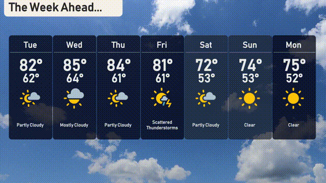
For the 7-day forecast in Atlanta:
Tuesday: Partly cloudy with a high of 82 degrees and a low of 62.
Wednesday: Mostly cloudy skies, warming up to 85 degrees and a low of 64.
Thursday: Partly cloudy again with highs around 84 degrees and lows near 61.
Friday: Look out for scattered thunderstorms with temperatures reaching up to 81 degrees during the day and a low of 61 at night.
Saturday: Cooler with a mix of sunshine and clouds, high of 72 degrees and low of 53.
Sunday: Clear skies and sunny with a daytime high of 74 degrees and an overnight low of 53.
Monday: Another clear day, rounding off your week with a high of 75 degrees and a low of 52.