Southeast Soars and Storms: A Week of Weather Wonders
By
Amy Freeze
From steamy highs to stormy evenings, read about the Southeast’s dynamic weather this week, including crucial updates for Atlanta and beyond.
This week in the Southeast brings a mix of partly cloudy skies and storm risks. Get the latest forecasts for Atlanta, Tampa, and more, with tips to stay weather-aware.
As we navigate another week in the Southeast, weather patterns are keeping us on our toes! From Atlanta’s mild days to the impending storms targeting Memphis and beyond, we’ll cover what these changes mean for your week. Plus, stay tuned for daily updates, as the weather is as unpredictable as ever. Ensure you’re prepared with our deep dive into regional conditions, safety tips, and much more.
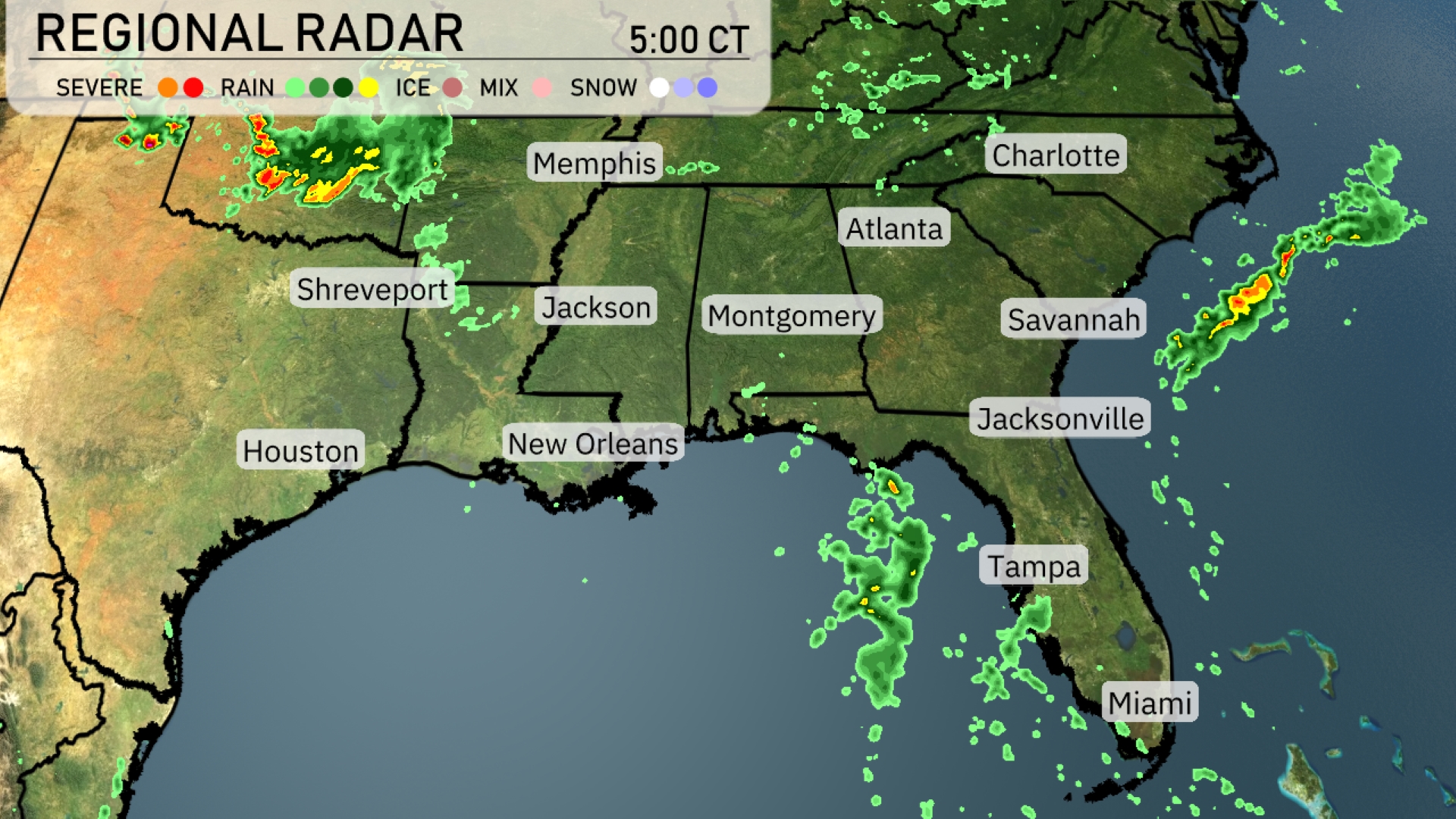
A line of severe storms is pushing through eastern Arkansas and heading toward the Memphis area, packing a punch with heavy rain. Scattered showers are drifting across northern Mississippi, stretching toward Jackson, while cloud cover increases over Atlanta, Georgia. Over in Florida, Tampa and Jacksonville are seeing some distressing downpours, which could play into increasing thunderstorms later on. The Gulf Coast from New Orleans to Houston enjoys a break from the rain with clearer skies.
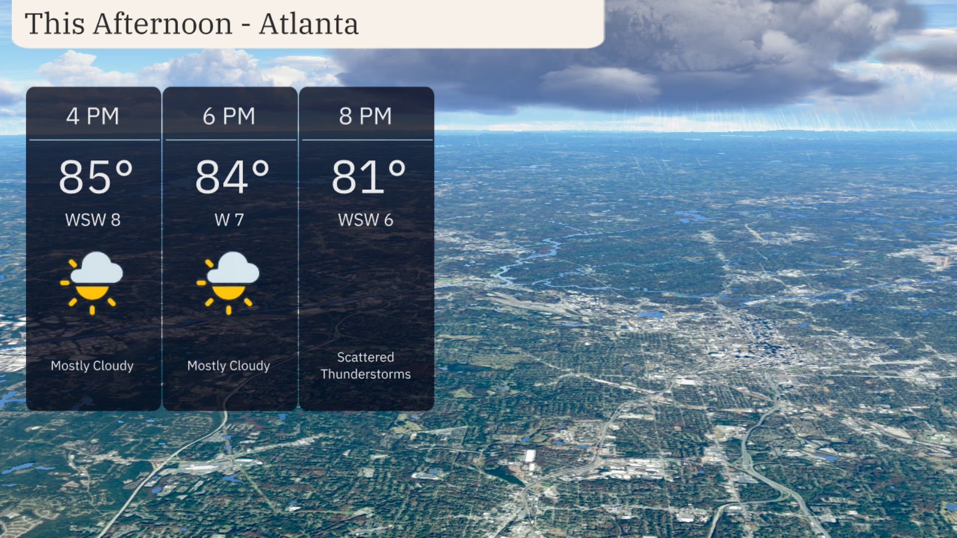
Atlanta temperatures through the afternoon will remain warm, peaking at 85 degrees around 4 PM with a west-southwest wind at 8 miles per hour. By 6 PM, temperatures slightly decrease to 84 degrees, and winds shift more westerly at 7 miles per hour, with mostly cloudy skies persisting. Expect scattered thunderstorms to develop by 8 PM as temperatures ease to 81 degrees and winds remain steady from the west-southwest at 6 miles per hour.
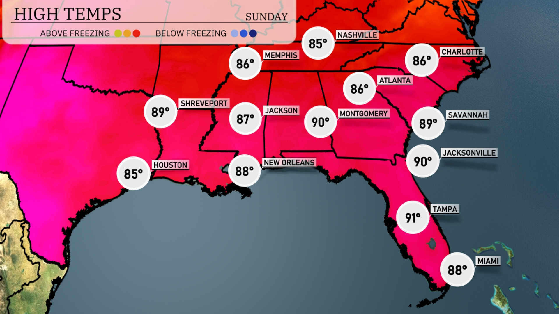
Today’s high temperatures in the Southeast are sizzling! In Jackson, we’ll see a high of 87 degrees, while New Orleans bakes at 88. Montgomery is hot at 90 degrees, with Jacksonville matching that temperature. Over in Tampa, expect a steamy high of 91, making it one of the warmest spots of the day. Shreveport will be slightly cooler at 89 degrees, providing a bit of relief in comparison.
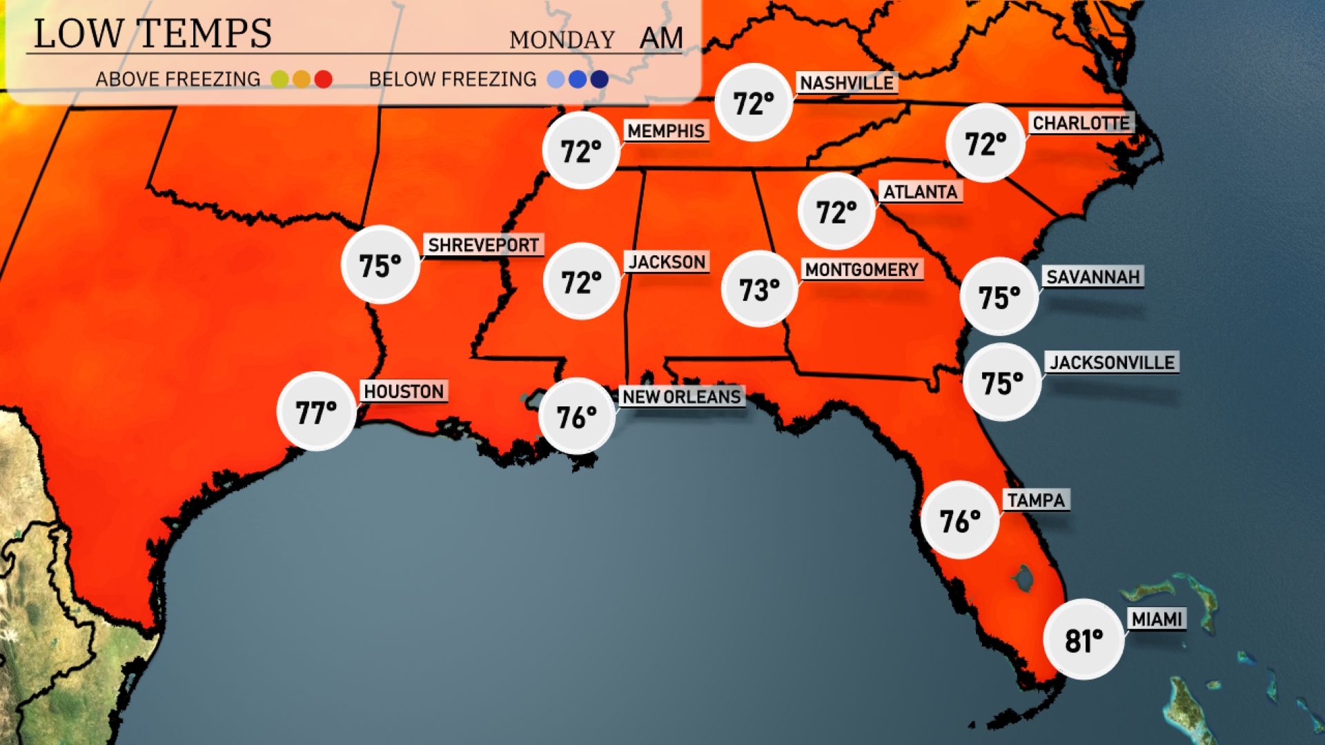
Tonight, Memphis will dip to 72 degrees. Expect lows around 72 for both Nashville and Montgomery. Jackson will register a low of 72, while Shreveport is set for 75 degrees. In Florida, Tampa will see a low of 76, while Miami remains warmer at 81 degrees.
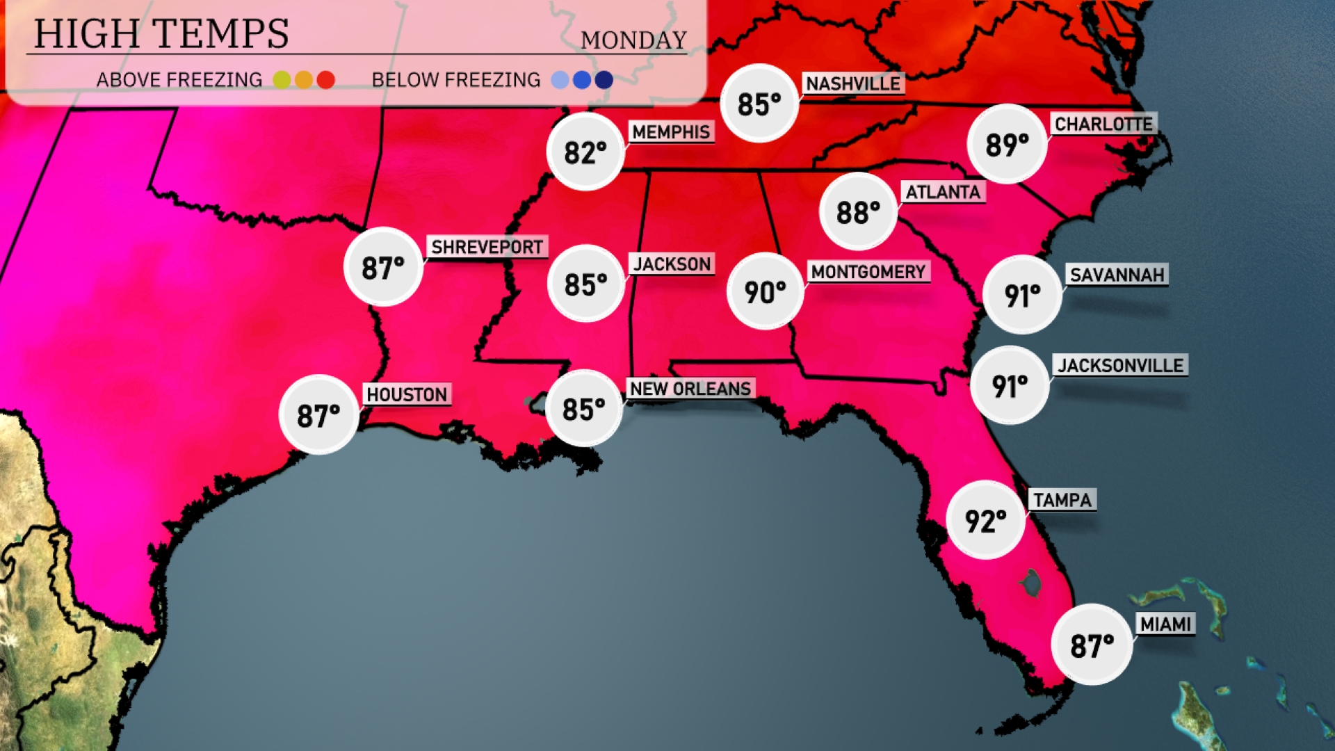
Tomorrow in Atlanta, expect a high of 88 degrees, while Montgomery will reach a balmy 90. Jacksonville is likely to hit 91, matching Savannah’s highs, bringing above-average warmth to the region. New Orleans can anticipate a comfortable 85 degrees, alongside Houston, which will also see 87. Tampa stands out with a high of 92 degrees, influenced by a building ridge of high pressure.
An active weather pattern is set to impact the Southeast tomorrow. A cold front moving in from the west will bring scattered thunderstorms from Houston to Jackson, with heavy rainfall and possible flooding. As the front progresses eastward, cities like Montgomery and Atlanta should prepare for strong storms during the afternoon hours. Storm activity extends across to Jacksonville and Savannah, bringing potential precipitation up to an inch or more. Behind the front, cool and dry conditions will settle across the region by late Wednesday into Thursday.
The UV index in Atlanta is high at 8 on Sunday, with a burn time of just 17 minutes, so take precautions against sun exposure. Monday brings an even more intense UV level of 10, with a rapid burn time of 12 minutes.