Southern Plains Weather Alert: Amy Freeze on Tomorrow’s Scattered Showers and Soaring Temps
By
Amy Freeze
Meteorologist Amy Freeze covers the latest Southern Plains weather, from clear mornings in Austin to storm alerts across the region. Find out how these conditions could affect your week ahead.
Discover the latest weather forecasts for Austin and the Southern Plains with Amy Freeze. From sunny starts to storm alerts, we’ve got your week covered.
Meteorologist Amy Freeze provides a comprehensive look at this week’s weather across the Southern Plains. Starting with Austin’s clear skies and stretching out to storm alerts in Little Rock, the regional weather overview offers a day-by-day breakdown, including temperature highs and potential storms. Essential sun safety tips are also highlighted, with Austin expecting a UV index of 8. Whether you’re planning your work week or preparing for potential severe weather, stay ahead with our detailed forecasts.
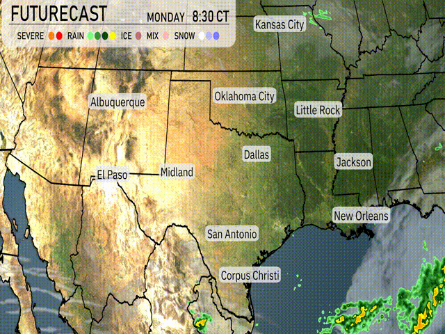
Across the Southern Plains, the regional radar shows a dynamic weather tapestry unfolding. Near Kansas City, light rain showers are making an appearance, providing a touch of spring moisture. Meanwhile, a robust cluster of showers with embedded thunderstorms is sweeping across the southeastern parts of the region, impacting New Orleans and spreading rain into the surrounding areas. Farther west, the skies remain clear around Albuquerque and El Paso, offering a break from precipitation. Dallas and areas stretching down to San Antonio and Corpus Christi are enjoying clearer conditions, allowing for a pleasant start to the day.
Tomorrow morning in Austin starts clear and calm with temperatures at 61 degrees by 7 AM. As the morning progresses, the sun makes its presence known, warming things up to 67 degrees by 9 AM. By 11 AM, temperatures climb to a comfortable 78 degrees accompanied by a gentle breeze from the south around 4 miles per hour.
High temperatures for the Southern Plains tomorrow are set to be well above average as warm air continues to dominate the region.
In El Paso, we expect a high of 86 degrees. Midland is heating up to a warm 90 degrees. San Antonio will see even higher temps, pushing up to 92 degrees. Over in Corpus Christi, a pleasant high of 82 degrees is on tap. Dallas is looking at a high of 85 degrees, while Oklahoma City is forecasted to reach 84 degrees.
Little Rock will also feel the warmth with a high of 85 degrees.
“Expect a busy weather day in the Southern Plains. Rain showers spread from Dallas to Corpus Christi, offering beneficial moisture. Oklahoma City could face stronger storms as an unstable air mass interacts with a cold front. Anticipate severe weather alerts for areas farther southeast through Wednesday night. In the range of cities like Little Rock and Jackson, thunderstorms will need attention through the evening commute. Stay tuned for updates on this evolving system.”
The UV index in Austin is projected to be 8 on both Monday and Tuesday, which is very high. This means sun protection is crucial, as unprotected skin can burn in just 17 minutes.
For the 7-day forecast in Austin:
Tuesday: Expect clear skies with a high of 93 degrees and a low of 61.
Wednesday: Partly cloudy conditions, with temperatures reaching 84 degrees and dipping to 64 at night.
Thursday: Showers arrive late in the day with a high of 71 degrees and a low around 62.
Friday: Rain is expected, bringing cooler weather with a high of 78 degrees and a low of 66.
Saturday: Scattered thunderstorms in the forecast with temperatures rising to 86 degrees and a low of 68.
Sunday: Partly cloudy skies prevail, with a high of 85 degrees and dipping overnight to 57.
Monday: The clouds start to clear as we enjoy mostly clear skies with a high of 79 degrees and a low of 59.
Enjoy your week ahead in Austin!