Southern Plains Weather Dynamics: From Storm Alerts to Sunny Days
By
Amy Freeze
Dive into the comprehensive weather analysis by Amy Freeze, covering severe storms, temperature trends, and regional forecasts across the Southern Plains.
Catch the latest forecast for Austin and the surrounding areas in the Southern Plains, featuring meteorologist Amy Freeze’s insights on upcoming weather patterns and potential severe conditions!
Meteorologist Amy Freeze provides an authoritative update on the Southern Plains’ weather patterns, detailing atmospheric conditions from Oklahoma to Texas. From storm predictions in New Orleans to stable weather in Dallas, this blog post offers vital information for navigating the fluctuating forecasts. Detailed daily temperatures, severe weather alerts, and safety suggestions are highlighted to keep you prepared.
Across the Southern Plains, the regional radar shows some active weather patterns. A band of severe storms is sweeping through the Gulf Coast, particularly impacting New Orleans, where heavy rainfall and potential thunderstorms can be expected. These storms are tracking eastward toward Jackson, where residents should prepare for intense weather conditions.
Meanwhile, in the northern part of this region, sky conditions remain relatively clear over Oklahoma City and Little Rock, offering dry weather for these areas. In contrast, some lighter rain activity is developing farther inland, near the lower Mississippi Delta, as a storm system begins to organize.
To the farther west, from El Paso to Albuquerque and across to Dallas, skies are predominantly clear, providing a respite from any severe weather. These regions are experiencing calmer weather conditions, though residents should remain weather-aware, as systems can change rapidly.
This afternoon in Austin, temperatures will hover in the low to mid-70s, peaking at 75 degrees around 5 PM. Anticipate partly cloudy conditions turning sunny as the afternoon progresses. Northeasterly winds will persist, though at a gentle pace, ranging between 6 to 7 miles per hour, maintaining a pleasant and stable weather pattern for the remainder of the day.
Let’s take a look at the high temperatures today across the Southern Plains.
In Texas, it’s a warm one with San Antonio and Corpus Christi each reaching a high of 83 degrees. Dallas sees a comfortable 71 degrees, while Midland is a bit hotter at 80 degrees. Over in El Paso, the warmth continues, hitting a solid 81 degrees.
Moving to Oklahoma, Oklahoma City registers a cooler 63 degrees, showcasing a notable temperature contrast with the southern cities.
Lastly, in New Orleans, we see a balmy high of 80 degrees.
Tonight in the Southern Plains, temperatures will take a noticeable dip as a cold front moves through the region. In Oklahoma City, expect a low of 34 degrees, with Tulsa dropping to 32. Dallas will see a cooler night at 40 degrees, while the temperature in Fort Worth will be close behind at 39. Over in Amarillo, temperatures are forecasted to bottom out at 30 degrees, making it one of the colder spots tonight. Meanwhile, Little Rock will register 36 degrees, and Shreveport is expected to cool down to 41. As we move farther south, San Antonio will have a low of 50 degrees, and Houston is looking at a mild 55 degrees.
Highs for the Southern Plains tomorrow are looking quite warm as we move into early April. In El Paso, expect a robust afternoon high of 82 degrees, while Midland is set to soar to a sizzling 90. San Antonio will enjoy a comfortable 84 degrees, and Corpus Christi is anticipated to reach 82. Dallas, however, will see a cooler 78 degrees, while Little Rock gets to a pleasant 77. In contrast, Kansas City is forecasted for a cooler 65 degrees. Overall, temperatures are notably above average for this time of year, driven by a warm air mass influencing the region.
The Southern Plains will experience a dynamic weather day tomorrow. Expect intermittent rain showers from Dallas to Corpus Christi, offering beneficial moisture. Oklahoma City should be on alert as stronger storms could develop, especially with an unstable air mass interacting with an advancing cold front. This system may trigger severe weather warnings, particularly in southern and eastern areas. Stay cautious for potential thunderstorms and localized flooding from late Wednesday night into Thursday. Temperatures will vary, with cooler air moving into western regions by Wednesday evening, providing some relief from recent warmth.
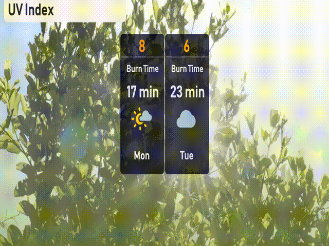
The UV index in Austin will reach 8 on Monday, indicating a very high level. Make sure to use sunscreen and wear protective clothing, as burn time can occur in just 17 minutes. On Tuesday, the index will moderate to 6, with a burn time of around 23 minutes.