From Cozy to Stormy: Navigating the Meteorological Tapestry of the Southern Plains
By
Amy Freeze
Meteorologist Amy Freeze guides us through a dynamic weather landscape in the Southern Plains, from gentle snow in New Mexico to thunderstorms threatening Oklahoma. Discover what these changes mean for your week ahead.
Catch the full spectrum of the Southern Plains weather with meteorologist Amy Freeze. From serene clear skies to looming storm threats, understand how to prepare for each day’s unique conditions in our detailed roundup.
Welcome to a detailed exploration of the Southern Plains’ weather conditions, presented by the expert meteorologist Amy Freeze. This comprehensive review starts in snowy New Mexico and stretches to the summer-like highs in Texas, providing an engaging and educational forecast. Key insights include temperature shifts, storm predictions, and essential tips for managing high UV index days in Austin. Whether you’re planning outdoor activities or just curious about the meteorological patterns affecting your area, this guide offers everything you need to stay informed and ready.
Across the Southern Plains, the regional radar reveals a bustling weather day. Snow is gently falling across the northern stretches of New Mexico, especially visible toward Albuquerque’s western outskirts, giving a hint of winter. Meanwhile, a mix of precipitation is seen along the Texas state line, highlighting areas such as the panhandle around Amarillo. The heart of Texas, from Midland to San Antonio, remains clear under current atmospheric conditions, providing a quiet respite. As we move eastward, Oklahoma City and Dallas are experiencing settled weather, with no significant precipitation.Keep an eye on the gathering clouds toward Jackson; while not yet in rain territory, they hint at upcoming changes. Farther southeast, cities like Little Rock and New Orleans are enjoying clear skies, making it a lovely day for some outdoor activities.
This evening in Austin, temperatures begin at 76 degrees around 7 PM with a light breeze from the south-southeast at 15 miles per hour. As the evening progresses, temperatures dip to 71 degrees by 9 PM and further to 68 degrees by 11 PM, with winds shifting slightly to the south at 13 miles per hour. Expect partly cloudy conditions throughout, offering a pleasant backdrop for any evening plans.
Now for the low temperatures across the Southern Plains tonight. Oklahoma City is bracing for a chilly 30 degrees, while Dallas will dip down to 42. Midland is expecting an even colder low of 33 degrees. In Texas, San Antonio will see a low of 46, and El Paso is forecasted at 35. Moving eastward, Little Rock will be at 40 degrees, and Jackson will have a low of 44 tonight. Overall, a cold air mass is settling in, bringing notable drops that residents should prepare for.
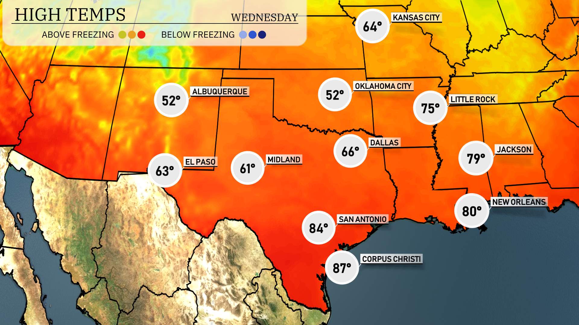
High temperatures for the Southern Plains tomorrow will show a mix of mild to warm conditions across the region. In El Paso, anticipate a high of 63 degrees, which is slightly below average for this time of year. Moving eastward, Midland warms up significantly to 85 degrees, reflecting above-average readings. San Antonio is set to reach 84 degrees, while Corpus Christi is expect to be the warmest in the area with a high of 87 degrees. Dallas will see a high of 66 degrees and Little Rock is forecasted at a comfortable 75 degrees. New Orleans will also enjoy a pleasant day with a high of 80 degrees. Weather patterns indicate a gradual warming trend, with some areas experiencing temperatures well above seasonal averages.
“Expect active weather across the Southern Plains. A cold front moves through, bringing scattered thunderstorms from Dallas to Little Rock tomorrow. Some storms may turn severe, with a risk of hail and damaging winds. Oklahoma City could see intense storm activity late in the day. Meanwhile, San Antonio to El Paso will remain dry and warmer. Stay alert for any severe weather alerts and flash flooding potential, especially in northeastern Texas and southeastern Oklahoma.”
The UV index in Austin is forecasted to reach a very high level of 8 on both Tuesday and Wednesday, with a burn time of approximately 17 minutes. To avoid sunburn, make sure to regularly apply sunscreen, wear protective clothing, and limit your time in direct sunlight during peak hours!
For the 7 Day Forecast in Austin:
Wednesday: Enjoy a partly cloudy day with some wind, reaching a high of 79 degrees and a low of 43.
Thursday: Clear skies dominate with temperatures reaching a high of 73 degrees and cooling to a low of 43.
Friday: Expect clear conditions as temperatures rise to a pleasant 83 degrees, with a low of 55.
Saturday: Mostly clear skies, warmer with a high of 86 degrees and a low of 66.
Sunday: Mostly cloudy, but still warm, with temperatures topping off at 87 degrees and a low of 58.
Monday: Thunderstorms are expected early in the day, clearing by afternoon. Look for highs around 84 degrees and lows at 58.
Tuesday: Mostly clear and notably warmer, hitting a high of 90 degrees with a low of 61.