Weather Whirlwind: Amy Freeze’s Comprehensive Guide to the Southern Plains’ April Forecast
By
Amy Freeze
Dive into a detailed analysis of the tumultuous weather sweeping across the Southern Plains, from severe storms to sunnier skies, with expert insights from meteorologist Amy Freeze.
Check out the latest weather updates for the Southern Plains as Amy Freeze guides you through a week of varied climates, from stormy evenings to pleasant sunny days.
As the Southern Plains face an active weather pattern, meteorologist Amy Freeze delivers in-depth analysis and forecasts. From severe storms across Kansas City to Oklahoma City to sunny forecasts in El Paso, get all the details to prepare for your week ahead. Plus, insights into UV risks and daily temperature trends for a safe and prepared outdoor experience. Don’t miss out on this crucial weather update for a well-planned week!
The Southern Plains are currently seeing an active weather pattern, with a line of severe storms stretching from Kansas City towards Oklahoma City, bringing heavy rain and potential severe weather. Moving southeast, Dallas and areas around Little Rock are experiencing scattered showers as rain bands extend toward these locations. Farther east, Jackson is also seeing cloud cover and rain from the storm system pushing through the region. In contrast, the southwest, including El Paso and Albuquerque, remains clear and dry. Some lighter showers are drifting through San Antonio, although Corpus Christi and the southern Texas coast are staying mostly dry for now.
This evening in Austin, temperatures will gently dip from 77 degrees at 9 PM to 66 degrees by 1 AM, creating a pleasant night. Winds will shift from northwest at 3 miles per hour to calm conditions as the evening progresses.
Tonight, the Southern Plains will experience some cool temperatures as colder air moves through the region. Expect a chilly low of 54 degrees in Little Rock. Dallas will drop to about 59 degrees, while Midland sits at 63 degrees. El Paso will be a bit warmer at 57 degrees. Farther south, San Antonio will remain mild at 70 degrees, with Corpus Christi slightly warmer at 72 degrees.
High temperatures in the Southern Plains tomorrow are expected to be well above average, with several areas experiencing a warm trend. El Paso will reach a high of 86 degrees, while Midland is set to peak at 86 as well. San Antonio will see a notable high of 90 degrees, which is significantly warmer than typical for this time of year. Dallas will experience a more moderate high at 82 degrees. Little Rock and Oklahoma City are also in the warm range, expected to hit 81 degrees.
A strong cold front will advance through the Southern Plains tomorrow, bringing significant weather changes. Starting in the morning, expect rain showers from Dallas to Corpus Christi, which will continue to provide much-needed moisture for the region. As the front progresses eastward, Oklahoma City could experience stronger storms, some potentially severe by the afternoon. Be especially alert for severe weather warnings as the unstable air mass interacts with the front, affecting areas like Little Rock and Jackson by late evening.
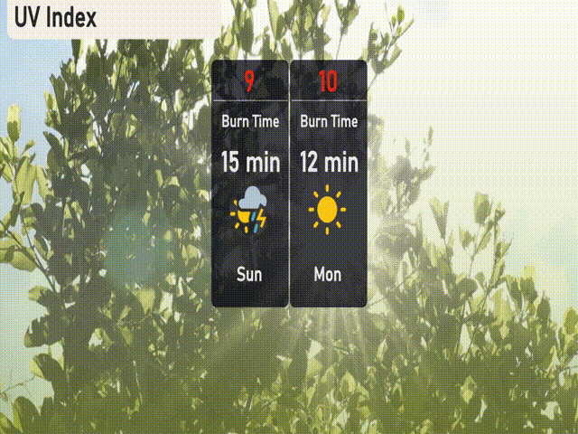
The UV index in Austin on Sunday will be very high, reaching 9, with a burn time of about 15 minutes, especially important if you’re spending time outdoors. On Monday, the UV index peaks at an extreme level of 10, with burn times as short as 12 minutes.
For the upcoming week in Austin:
Sunday: Clear skies with a high of 83 degrees and a low of 56.
Monday: Partly cloudy with the temperature climbing to 88 degrees, dropping to 68 at night.
Tuesday: Thunderstorms likely, with a high of 87 degrees and a low of 67.
Wednesday: Isolated thunderstorms expected, the high will be 80 degrees with a low of 69.
Thursday: Thunderstorms return late, reaching a high of 84 degrees, dipping to 70 overnight.
Friday: Mostly cloudy conditions prevail, with a high of 85 degrees and a low of 70.
Saturday: Mostly cloudy once more, the temperature will peak at 86 degrees and the low will be 70.