Weather Whirlwind: Navigating Austin’s Varied Temperatures and Showers!
By
Amy Freeze
Dive into the dynamic weather patterns of the Southern Plains with Meteorologist Amy Freeze. From unexpected showers to sunny highs, here’s everything you need to know about this week's weather in Austin!
Meteorologist Amy Freeze brings your Southern Plains weather forecast. From warm, sunny afternoons in Austin to potential rain showers across Texas and nearby areas. Stay tuned for daily updates!
This week in Austin, expect a whirlwind of weather conditions. From predominant sunny skies in the afternoon to a sneak peek at rain showers as we move towards Dallas. Join Meteorologist Amy Freeze on a detailed exploration of fluctuating temperatures and learn how to plan your days around the weather. Remember, whether it’s sunny or stormy, we’re here to keep you informed and prepared!
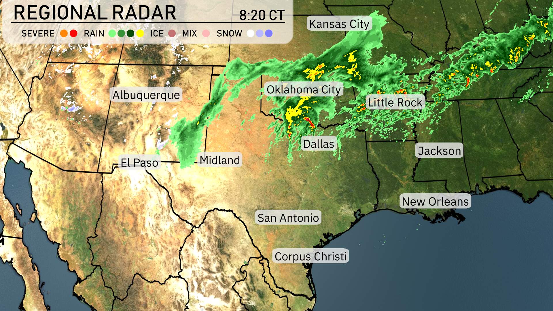
In the Southern Plains region, the regional radar reveals a dynamic weather pattern today. There’s a notable band of rain stretching from Oklahoma City northeastward towards Little Rock. Showers associated with this band are moving through, bringing significant precipitation to the area. Meanwhile, Kansas City is experiencing cloudy conditions as the rain approaches from the south.
Farther south, Dallas remains cloudy with occasional rain showers expected to increase as the weather system continues its journey across the region. Conditions around Jackson are currently dry, but the radar suggests that rain moving from the northwest could soon affect the area. El Paso and Albuquerque are under clear skies, enjoying a break from any weather disturbances.
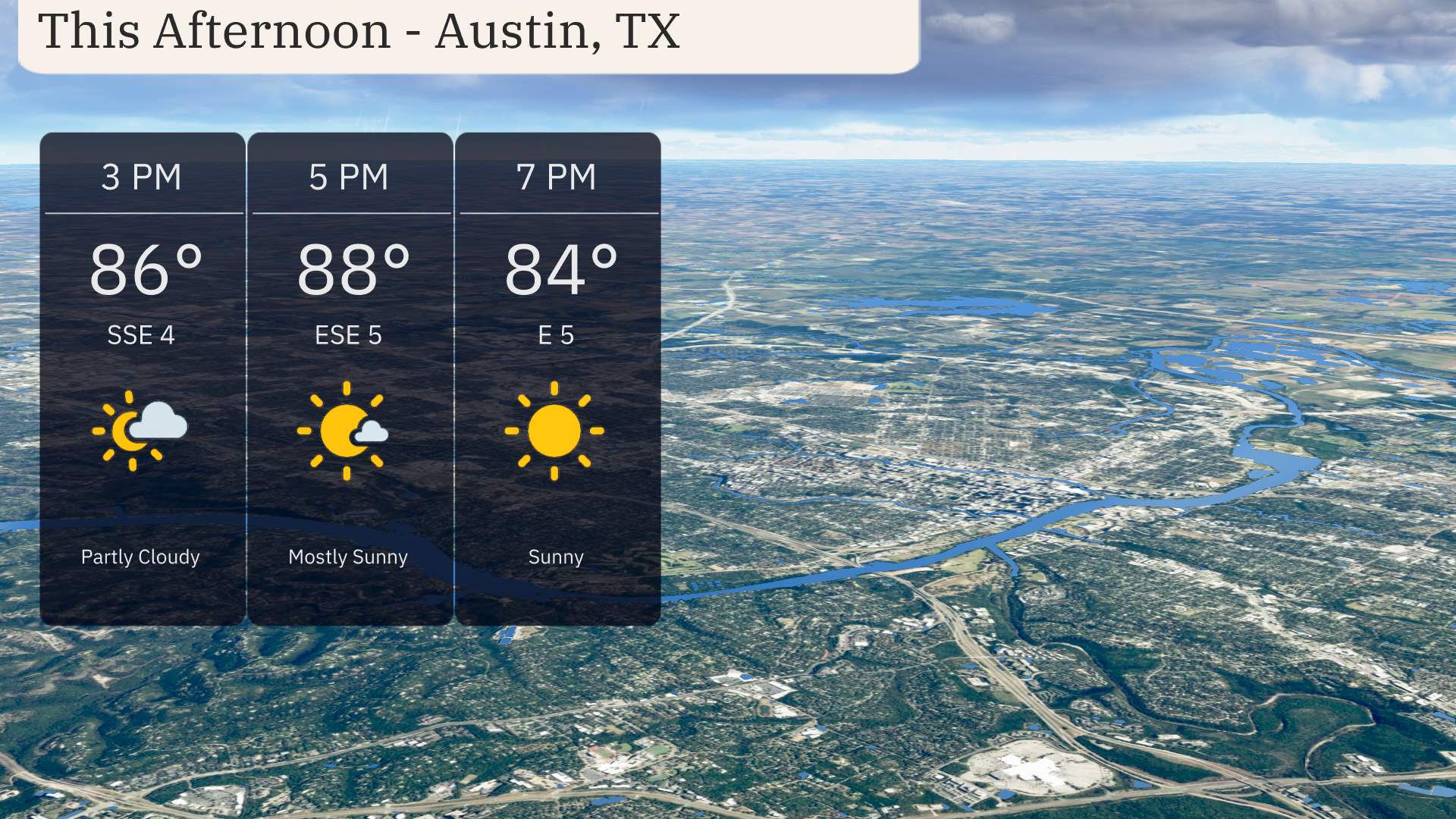
This afternoon in Austin, expect warm temperatures reaching 86 degrees by 3 PM, rising to 88 degrees by 5 PM, before cooling slightly to 84 degrees at 7 PM. Skies will shift from partly cloudy to mostly sunny as the afternoon progresses, accompanied by gentle southeast to east-southeast winds at 4 to 5 miles per hour. Perfect conditions for outdoor activities as the day brightens up!
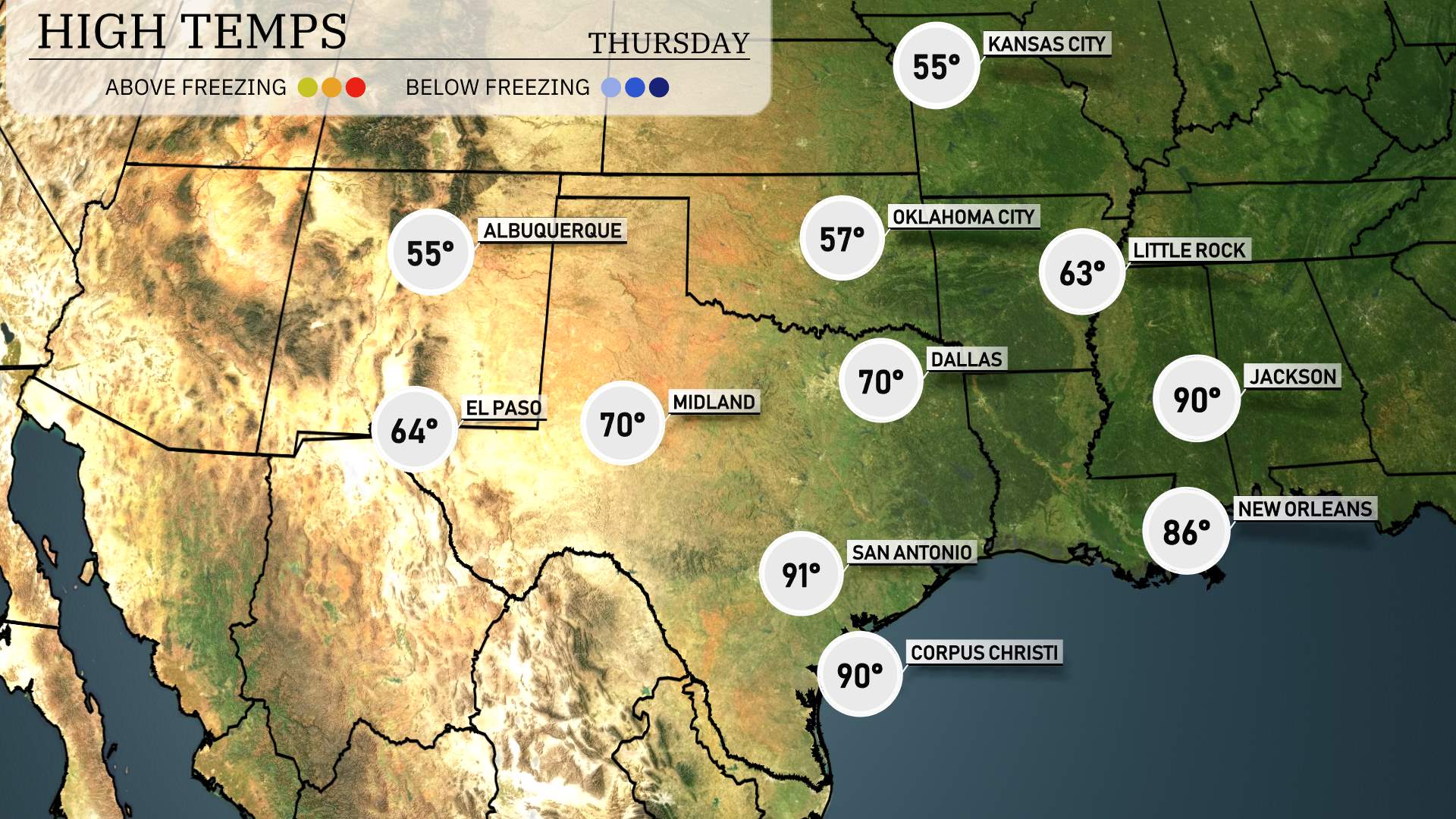
Good afternoon! Let’s take a look at today’s high temperatures in the Southern Plains.
In Texas, we’re seeing warmer conditions with San Antonio reaching a sizzling 91 degrees, and both Corpus Christi and Midland reporting 90 and 70 degrees, respectively. Dallas is not far behind at a pleasant 70 degrees.
Moving into Oklahoma, temperatures are a bit cooler, with Oklahoma City expecting a high of 63. Over in Arkansas, Little Rock will see a mild 63 degrees today.
Down south, in New Mexico, El Paso is maintaining a comfortable high of 64 degrees. Overall, we have a noticeable contrast across the region, with those warmer spots in Texas compared to the cooler air in Oklahoma and Arkansas. Stay tuned for updates!
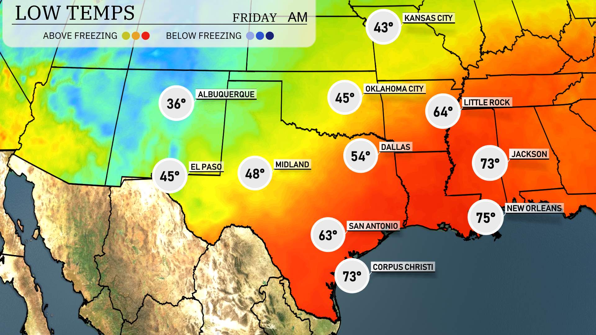
Tonight, the Southern Plains will see some notably chilly temperatures as a cold front sweeps through the region. In Oklahoma City, expect a low of 45 degrees, while Tulsa will drop to 42. Dallas is forecast to be slightly warmer at 54 degrees, but farther to the west, Amarillo will experience a significant chill with a low of 37. In Texas, San Antonio will cool down to 63 degrees. Meanwhile, down in the Gulf region, Houston will remain milder at 67 degrees. Be prepared for a brisk night across the Southern Plains!
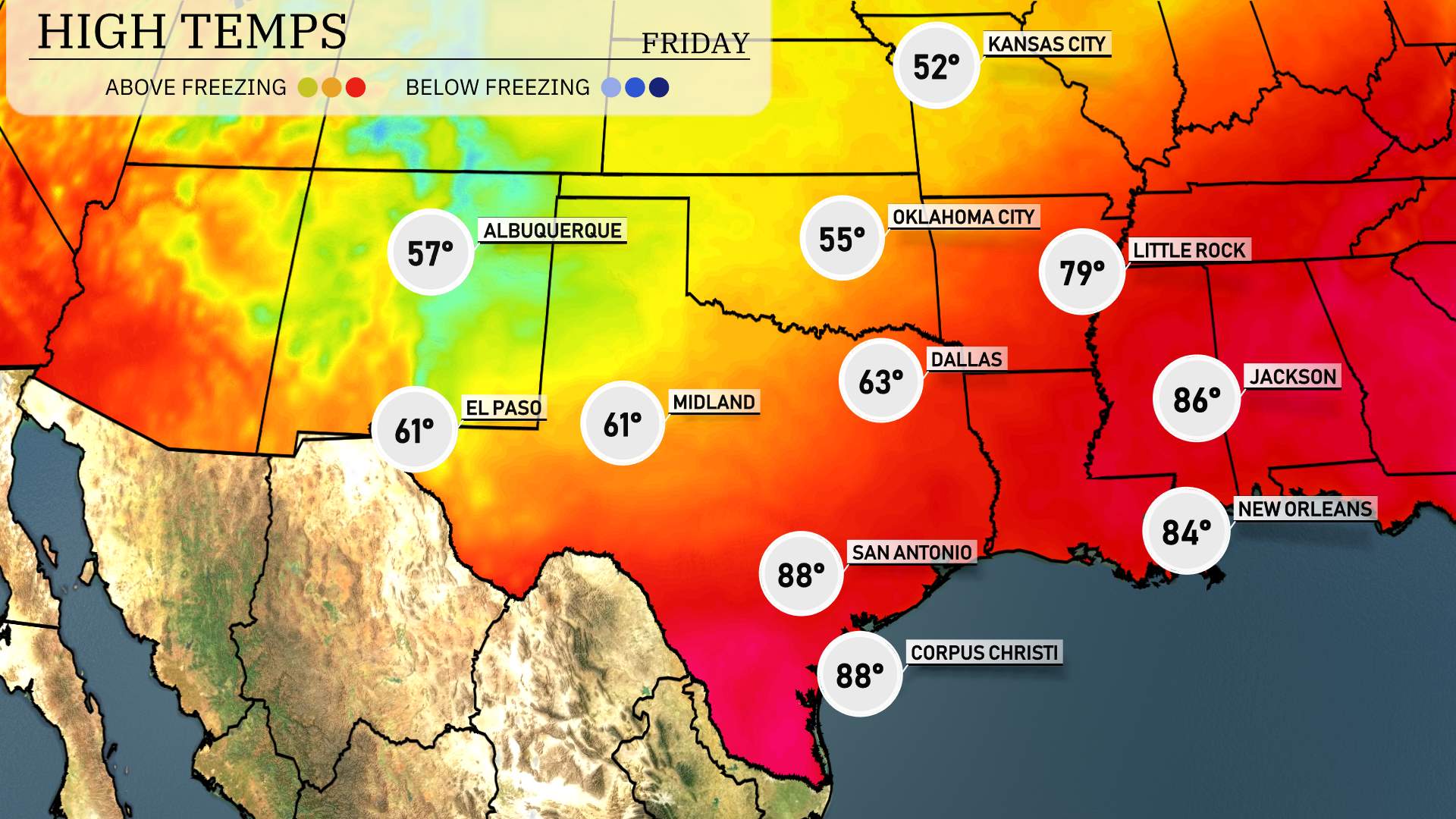
High temperatures for the Southern Plains tomorrow are leaning towards the warm side, with some notable variances across the region.
In El Paso, the high is expected to be a comfortable 74 degrees. Midland will experience warmer temperatures, reaching up to 85 degrees, which is slightly above average for this time of year. San Antonio is looking at a warm 81 degrees under mostly sunny skies. Meanwhile, Corpus Christi will enjoy a balmy 79 degrees as coastal conditions keep temperatures mild.
In the major metro areas, Dallas is set to see a cooler 67 degrees, remaining below average, while Oklahoma City lags behind at 55 degrees. Kansas City, farther north, is forecasted for a cooler 52 degrees.
Expect a dynamic day across the Southern Plains tomorrow. Rain showers will primarily cover areas from Dallas to Corpus Christi, bringing much-needed moisture. Oklahoma City may experience stronger storms due to an unstable air mass combined with an incoming cold front. Be alert for possible severe weather warnings through Wednesday night as these conditions progress eastward. Areas farther east, including Little Rock, will see showers shifting during the afternoon. Kansas City and farther east should anticipate light rain moving out by late afternoon.
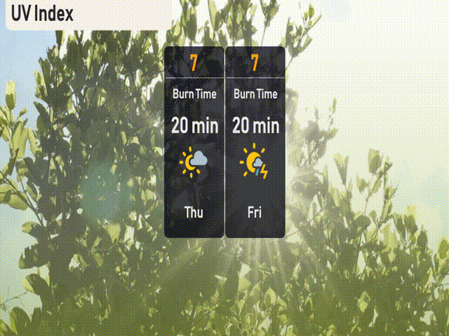
The UV index in Austin will be high with a level of 7 on both Thursday and Friday, with a burn time of about 20 minutes in direct sunlight. Remember to apply sunscreen and seek shade during peak sun hours to stay protected!