March Showers and Rising Temps: Your Comprehensive Southern Plains Weather Forecast
By
Amy Freeze
From Austin's gentle morning breezes to unexpected rain across the Southern Plains, stay prepared with our detailed weather analysis by Meteorologist Amy Freeze.
Amy Freeze shares a timely update for Austin and the surrounding Southern Plains. Partly cloudy skies, rain, and a warming trend—are you prepared for the week ahead?
The Southern Plains are seeing diverse weather patterns this week, with Austin waking up to partly cloudy skies and mild morning temperatures. As a cold front moves in, various regions from Midland to New Orleans brace for rains and potential storms. Meteorologist Amy Freeze gives an in-depth look at what to expect, including temperature trends and safety tips for higher UV indexes. Tune into this week’s forecast to stay ahead of the weather!
Across the Southern Plains, the radar reveals a largely calm setup. The higher elevations near the southern Colorado border are experiencing snowfall, with gusty winds reaching up to 75 miles per hour in the mountain passes, enhancing the wintry conditions. In the Oklahoma Panhandle, a few rain showers are making their way through, hinting at a change in the otherwise calm weather. Meanwhile, the lower Mississippi Delta is seeing rain developing as a storm system begins to take shape, promising wet conditions moving forward.
Expect a mostly cloudy start in Austin tomorrow morning, with temperatures beginning at 65 degrees at 7 AM and slowly rising to 72 degrees by 11 AM. Winds will be coming from the south at a gentle pace, moving from 3 miles per hour to 4 miles per hour as the morning progresses.
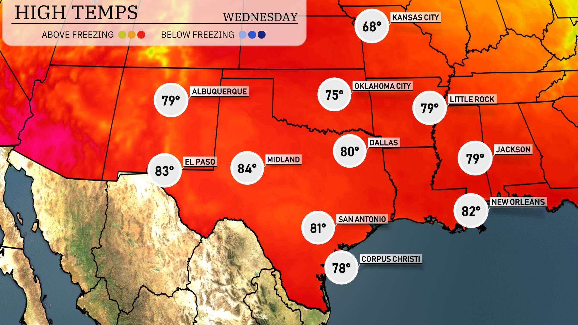
Highs for the Southern Plains tomorrow will be warmer than average as we see an influx of warm air across the region. El Paso is set to reach 83 degrees, while Midland will experience even higher temperatures at 84 degrees. San Antonio is expected to hit 81 degrees, providing a pleasant day. Corpus Christi will see a high of 78 degrees. In Dallas, the temperature will climb to 80 degrees, marking a notable increase compared to typical late March readings. Little Rock rounds out the forecast with a warm 79 degrees, indicating a generally mild trend for this time of year across the Southern Plains.
“A cold front is moving into the Southern Plains, bringing a mix of weather patterns. Expect periods of rain from Midland through San Antonio and Corpus Christi over the next 24 hours, providing beneficial rain. However, prepare for potential severe storms in Oklahoma City, where unstable conditions may lead to weather alerts. Little Rock and Jackson should watch out for the line of storms advancing during Wednesday evening. As the front progresses farther east, keep an eye out for possible storm intensities in New Orleans by late Wednesday. Stay weather-aware, as strong winds and potential flash flooding might occur.”
The UV index in Austin will reach a high of 8 on Tuesday, indicating a strong risk when spending time outdoors, with a burn time of approximately 17 minutes. Exercise caution by applying sunscreen and wearing protective clothing. On Wednesday, expect the UV index to moderate at 5, extending the burn time to about 27 minutes, particularly with cloudier conditions. Stay sun-smart and enjoy your time safely!
For the 7-Day Outlook in Austin:
Wednesday: Partly cloudy with a warm high of 83 degrees and a low of 64.
Thursday: Showers expected late with a high of 69 degrees and a low of 61.
Friday: Expect more showers throughout the day, with a high of 77 degrees and a low of 64.
Saturday: Partly cloudy skies and temperatures rising to 87 degrees, cooling to 67 at night.
Sunday: A continuation of partly cloudy weather with a daytime high of 89 degrees and a nighttime low of 58.
Monday: Mostly clear with a pleasant high of 78 degrees and a low of 57.
Tuesday: Partly cloudy again, reaching a high of 82 degrees.
Hope that helps!