Thunder and Sunshine: This Week’s Weather Dynamics Across the Southern Plains
By
Amy Freeze
Explore the varied weather patterns sweeping across the Southern Plains, from Austin's mild evenings to the stormy forecasts in Oklahoma City and beyond.
Catch up on the latest weather updates for the Southern Plains, including thunderstorms, clear skies, and temperature changes. Stay informed and prepared with insights from meteorologist Amy Freeze.
Welcome to our detailed weather forecast update for the Southern Plains. This week, our regions experience a mix of thunderstorms and clear, sunny spells. Austin remains partly cloudy with mild temperatures, while cities like Dallas brace for incoming storms. Stay tuned as we track these patterns and provide you with all the necessary details to plan your week effectively. For more info, visit our blog at https://amyfreeze.ai/
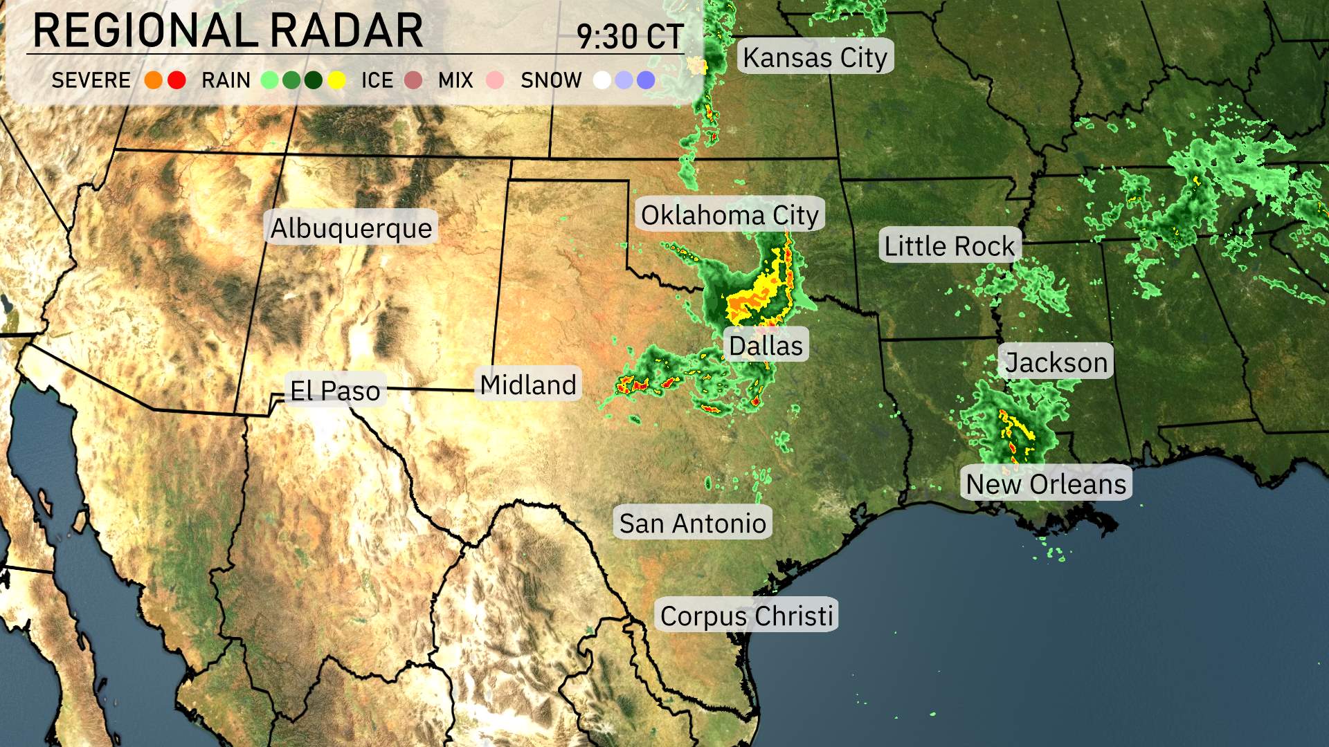
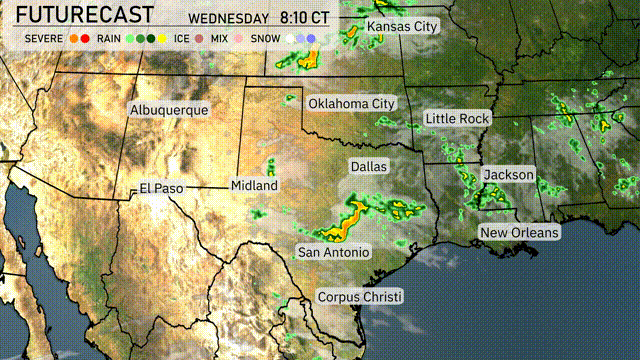
A weather pattern across the Southern Plains shows a band of strong thunderstorms stretching from near Oklahoma City down towards the Dallas area. These storms are moving east and will bring rain to Little Rock and eventually into Mississippi. Jackson is experiencing heavy rains as the storm system progresses through. El Paso and Midland enjoy clear conditions, offering a sunnier break from the unsettled weather eastward. San Antonio and Corpus Christi remain dry for now, though the skies might see increasing clouds as the day goes on.
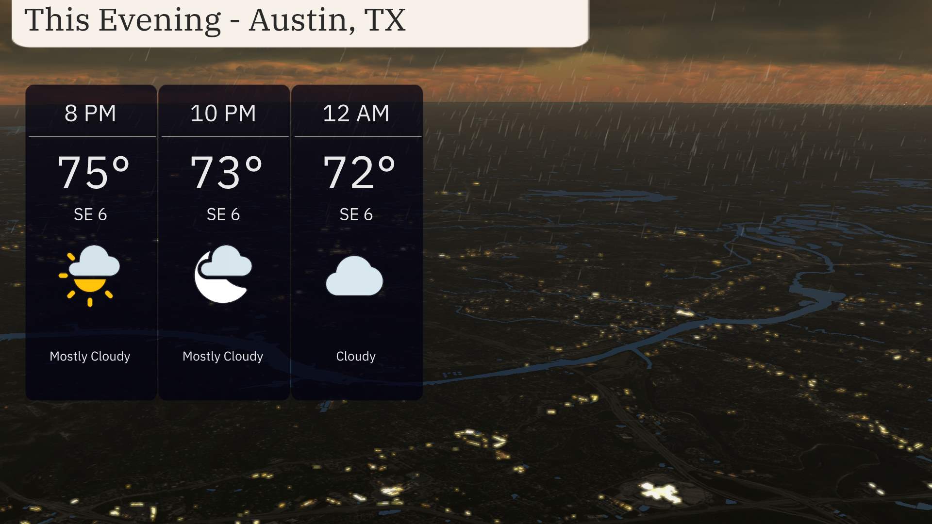
The evening in Austin sees temperatures starting at 75 degrees at 8 PM, gently cooling to 72 degrees by midnight. Winds are consistent from the southeast at 6 miles per hour.
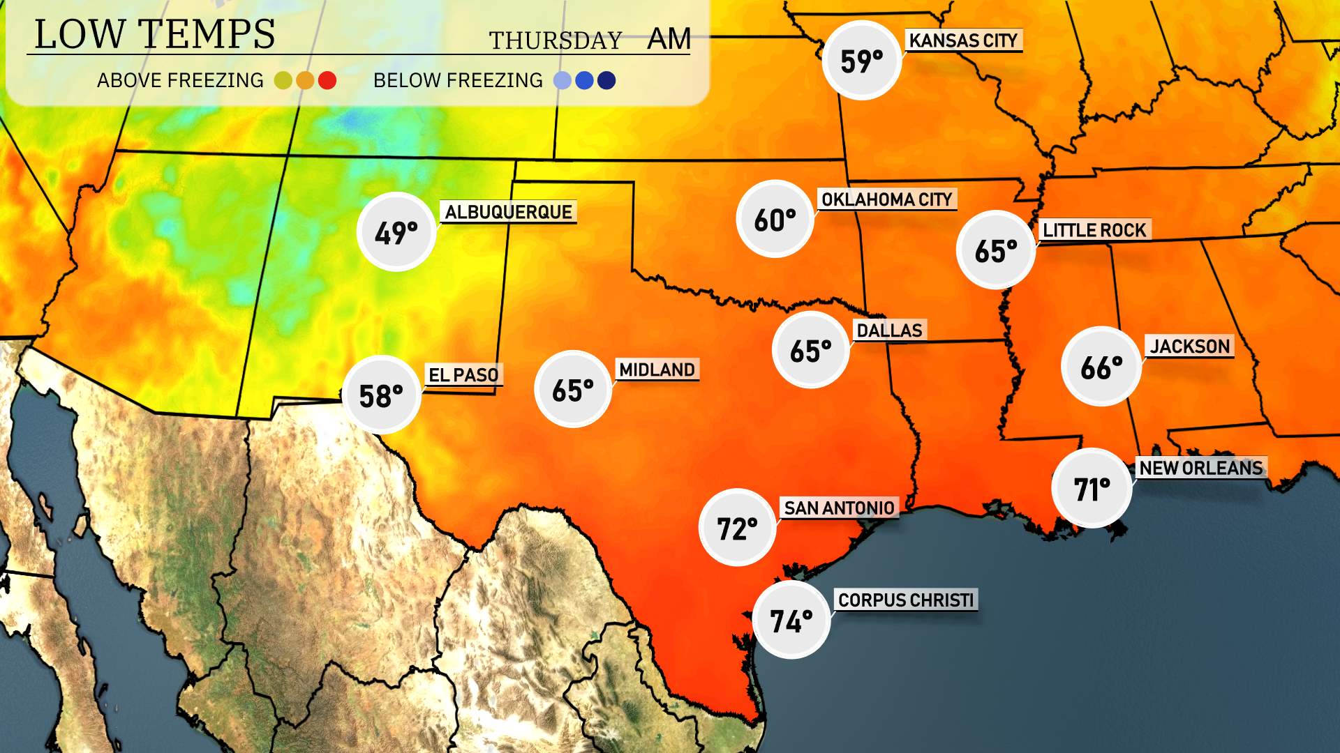
Dallas will see a low of 60 degrees, while Little Rock drops to 65. Oklahoma City is looking at a chilly 59 degrees, and Jackson will experience a low of 66. San Antonio remains milder at 72, but Corpus Christi will only get down to 74. El Paso will register a low of 58, marking a noticeable drop in temperatures across the region.
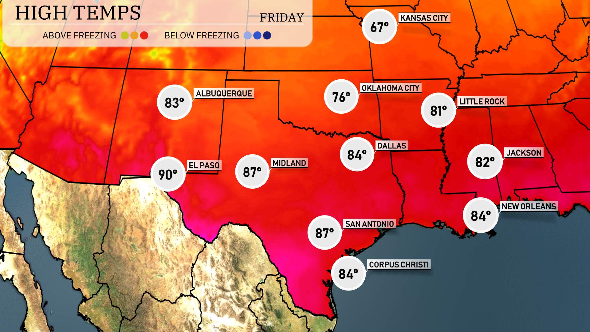
High temperatures for the Southern Plains tomorrow will be well above average, contributing to a warm day across the region. El Paso sizzles with a high of 90 degrees, while Midland also sees a warm day with temperatures reaching 87. San Antonio and Corpus Christi will match at 87 degrees, indicating a balmy afternoon. Dallas should experience a pleasant 84 degrees, and Little Rock forecasts a high of 81. Oklahoma City checks in at a comfortable 76 degrees as the warm air continues to dominate the region.
A cold front is advancing through the Southern Plains bringing rain from Dallas to San Antonio by tomorrow morning. Oklahoma City faces the potential for stronger storms and isolated severe weather. Areas from Little Rock to Jackson should stay alert as the front progresses eastward, with showers and occasional thunderstorms expected. New Orleans and the Gulf Coast region might experience brief downpours and gusty winds. Temperatures will drop slightly behind the front, ushering in cooler air and clearing skies by Thursday evening.
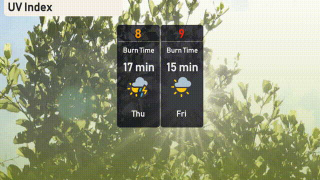
The UV index in Austin is very high, reaching 8 on Thursday with a burn time of just 17 minutes, signaling the need for strong sun protection. It climbs even higher to 9 on Friday, reducing the burn time to an even shorter 15 minutes.
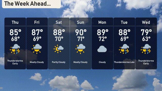
Thursday: Thunderstorms early with a high of 85 degrees and a low of 68.
Friday: Mostly cloudy, warming up to 87 degrees with the low at 69.
Saturday: Expect partly cloudy skies and a warm high of 88 degrees, with nighttime temperatures of 70.
Sunday: Mostly cloudy with a high reaching 90 degrees and a low of 71.
Monday: Cloudy with temperatures peaking at 89 degrees and dipping to 72 overnight.
Tuesday: Thunderstorms expected late, with a high of 88 degrees and a low of 69.
Wednesday: Cooler with thunderstorms, the high will be 79 degrees and the low 63.