Southern Plains Weather Watch: A Stormy Evening Forecasted across Austin!
By
Amy Freeze
Meteorologist Amy Freeze provides a detailed update on the evolving weather conditions over Austin and the surrounding Southern Plains. From severe thunderstorms to sunny reprieves, get the full scoop here!
Stay updated with the latest weather insights as Amy Freeze covers the evolving stormy conditions and sunny days across Austin and the Southern Plains. Visit our blog for all the details.
Welcome to our detailed coverage of the Southern Plains’ weather with Meteorologist Amy Freeze. Tonight, Austin braces for scattered thunderstorms, while areas like Corpus Christi face severe thunderstorms. Meanwhile, Dallas sees much lighter showers. This update includes a regional breakdown of weather changes, temperature expectations, and important safety tips for upcoming severe conditions. Don’t miss any updates, check our full article.
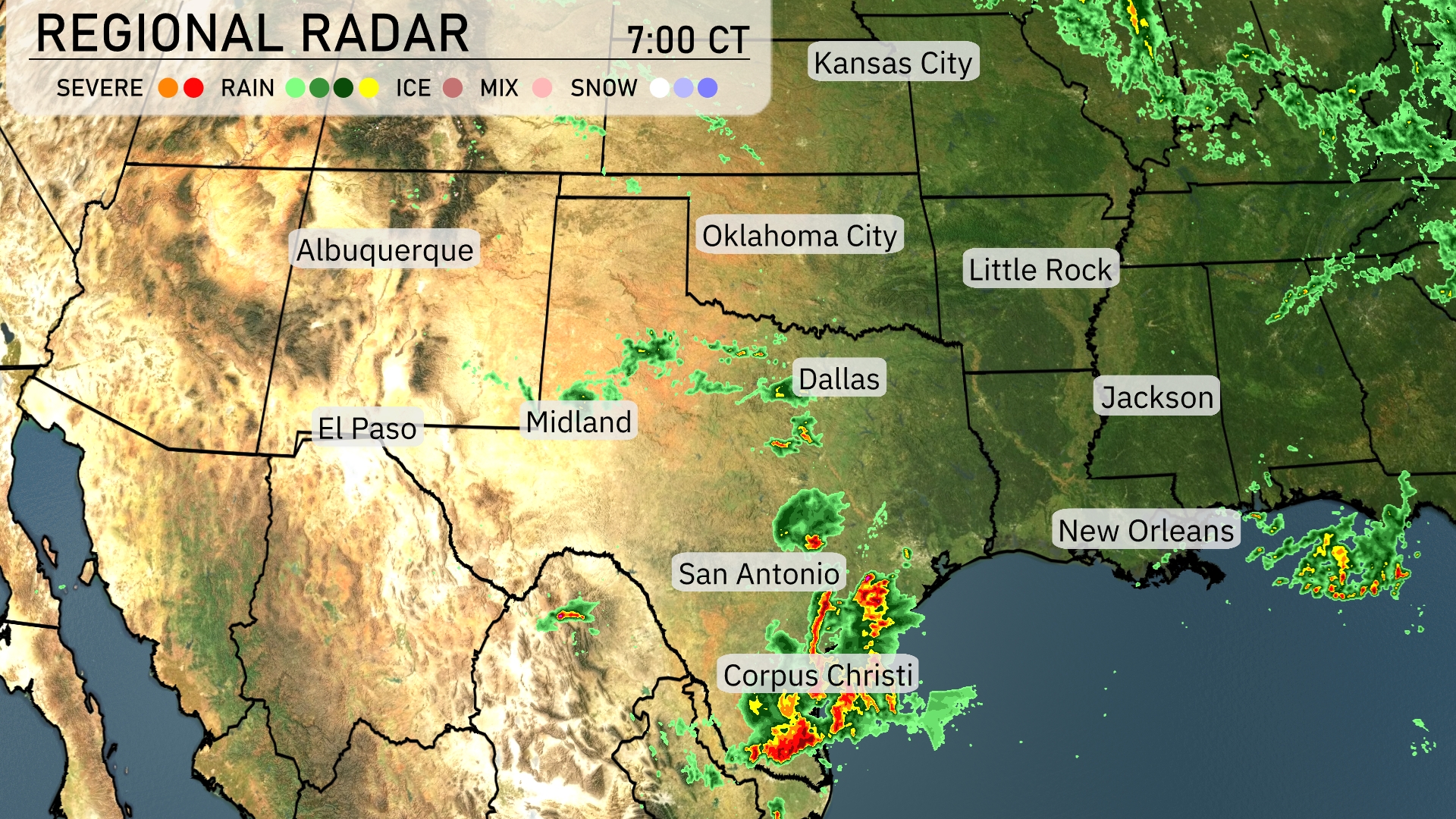
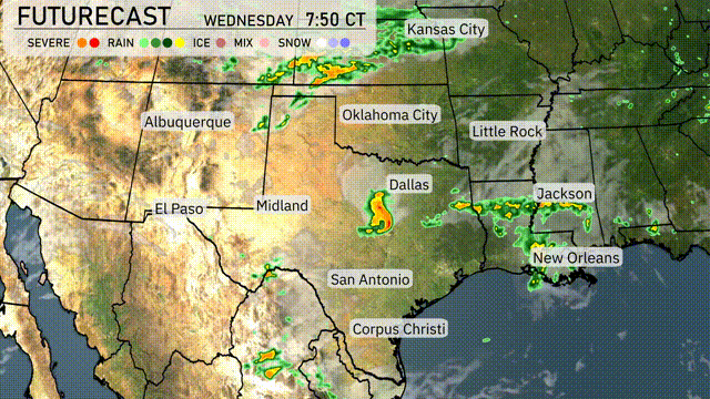
On the Regional Radar, severe thunderstorms are currently impacting Corpus Christi, pushing towards the northeast into the coastal areas of Texas. San Antonio may soon see some rain as the storm system progresses. Dallas is experiencing scattered showers though nothing severe at the moment. Meanwhile, cloud cover extends into the Oklahoma City region with potential rain development. Near El Paso, the weather remains clear, offering a reprieve from the stormy conditions elsewhere.
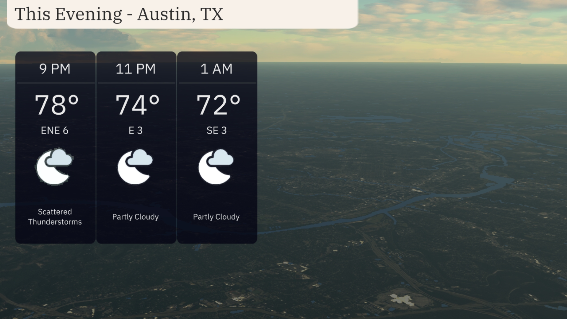
For this evening in Austin, anticipate scattered thunderstorms at 9 PM with temperatures around 78 degrees and winds from the east-northeast at 6 mph. By 11 PM, conditions will shift to partly cloudy skies, with temperatures cooling slightly to 74 degrees and easterly winds at 3 mph. Expect a continued partly cloudy trend at 1 AM, with temperatures dipping to 72 degrees and southeast winds at 3 mph.
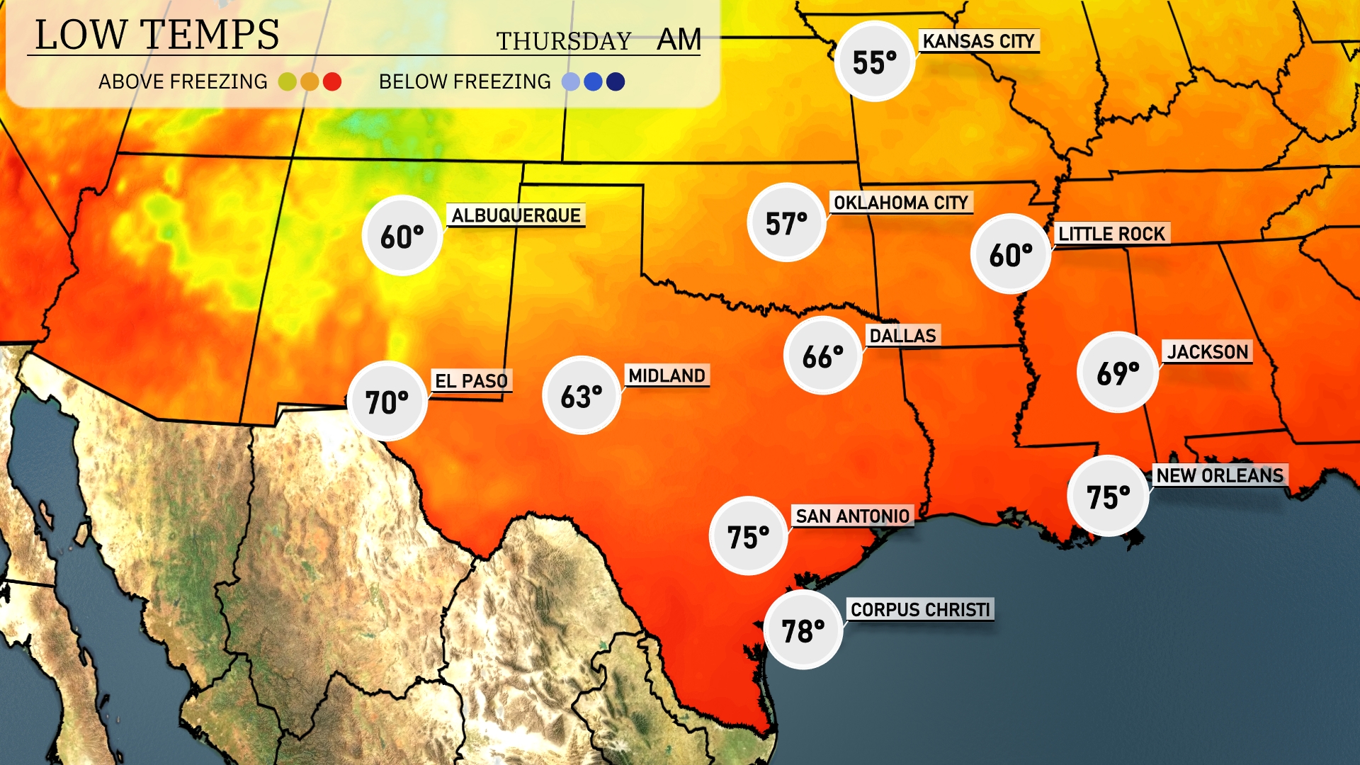
Tonight in Oklahoma City will see a low of 55 degrees, while Dallas checks in at 66. Up north, Little Rock will experience a chilly 60 degrees. Farther west, Midland is predicted to cool down to 63 degrees. Expect warmer temperatures along the coast, with San Antonio at 75 and Corpus Christi at 78.
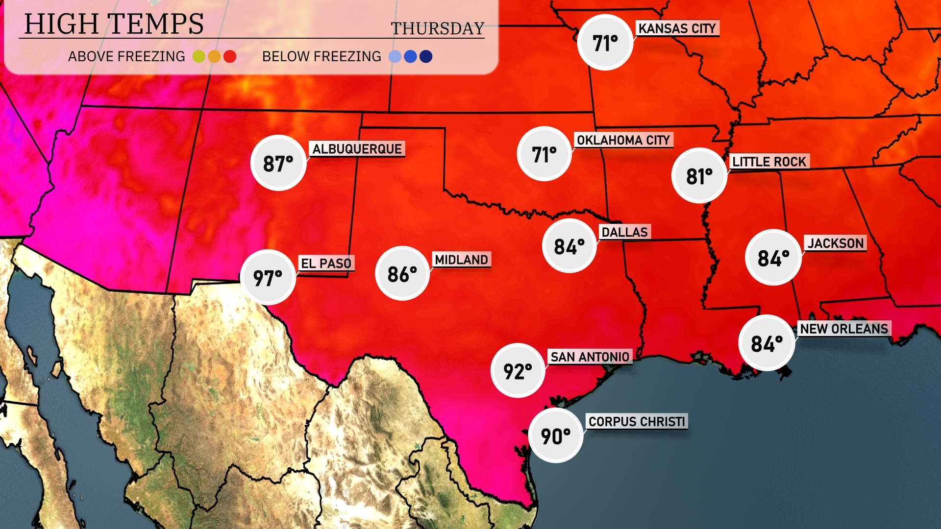
Tomorrow El Paso is looking at a high of 97 degrees, while Midland will reach 86 degrees. San Antonio is set for a toasty 92 degrees, and Corpus Christi will hit 90 degrees. Dallas is expected to see a high of 84 degrees. In Little Rock, temperatures will be slightly cooler, with a high of around 81 degrees.
Expect an active weather day across the Southern Plains as a cold front progresses through the region. Severe thunderstorms are possible from Dallas to Oklahoma City, with potential for damaging winds and isolated tornadoes. Rain showers extend from San Antonio to Corpus Christi, providing needed moisture but possibly leading to localized flooding. By evening, the storm system advances towards the southeastern states, increasing thunderstorm activity.
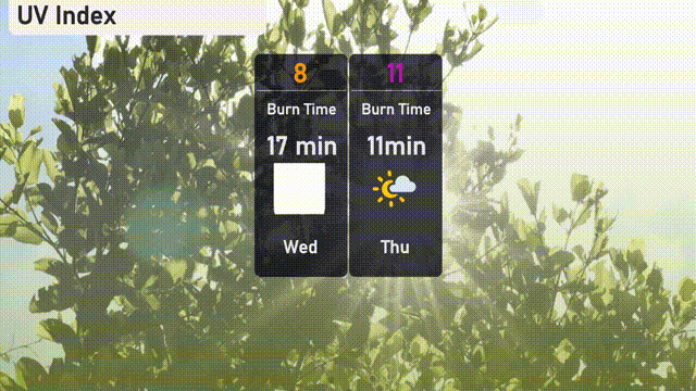
The UV index in Austin will reach a very high level of 8 on Wednesday, with a burn time of just 17 minutes. By Thursday, the UV index climbs to an extreme level of 11, where unprotected skin can burn in only 11 minutes.
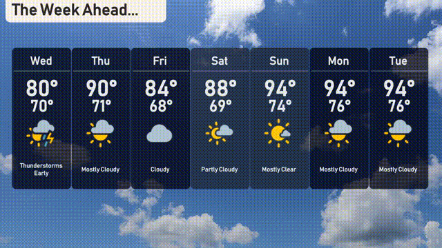
For the 7-day forecast in Austin:
Wednesday: Early thunderstorms with a high of 80 degrees and a low of 70.
Thursday: Mostly cloudy skies, warming up to 90 degrees and a low of 70.
Friday: Continuing cloudy with a high of 84 degrees and a low of 68.
Saturday: Partly cloudy and warmer, reaching up to 88 degrees and a low of 69.
Sunday: Mostly clear with the temperatures peaking at 94 degrees and dipping to 74 overnight.
Monday: Mostly cloudy, maintaining a warm high of 94 degrees, with a low of 76.
Tuesday: Mostly cloudy conditions persist with a high of 94 degrees and a low of 76.