Tempest Over Texas: Tracking the Southern Plains Weather Phenomenon
By
Amy Freeze
Explore a week of dynamic weather across Austin and the Southern Plains, from stormy onslaughts to sunny spells, and how these shifts impact your daily preparations.
Dive into this week’s Southern Plains weather forecast. From stormy evenings to sunny days, discover what’s ahead for Austin and its neighbors.
This detailed weather report for the Southern Plains covers everything from the expected storm systems moving through Texas to the unpredictable beauty of partly cloudy Austin skies. Stay prepared with forecasts for temperature drops, storm warnings, and sunny interim days as well as essential safety tips for high UV levels.
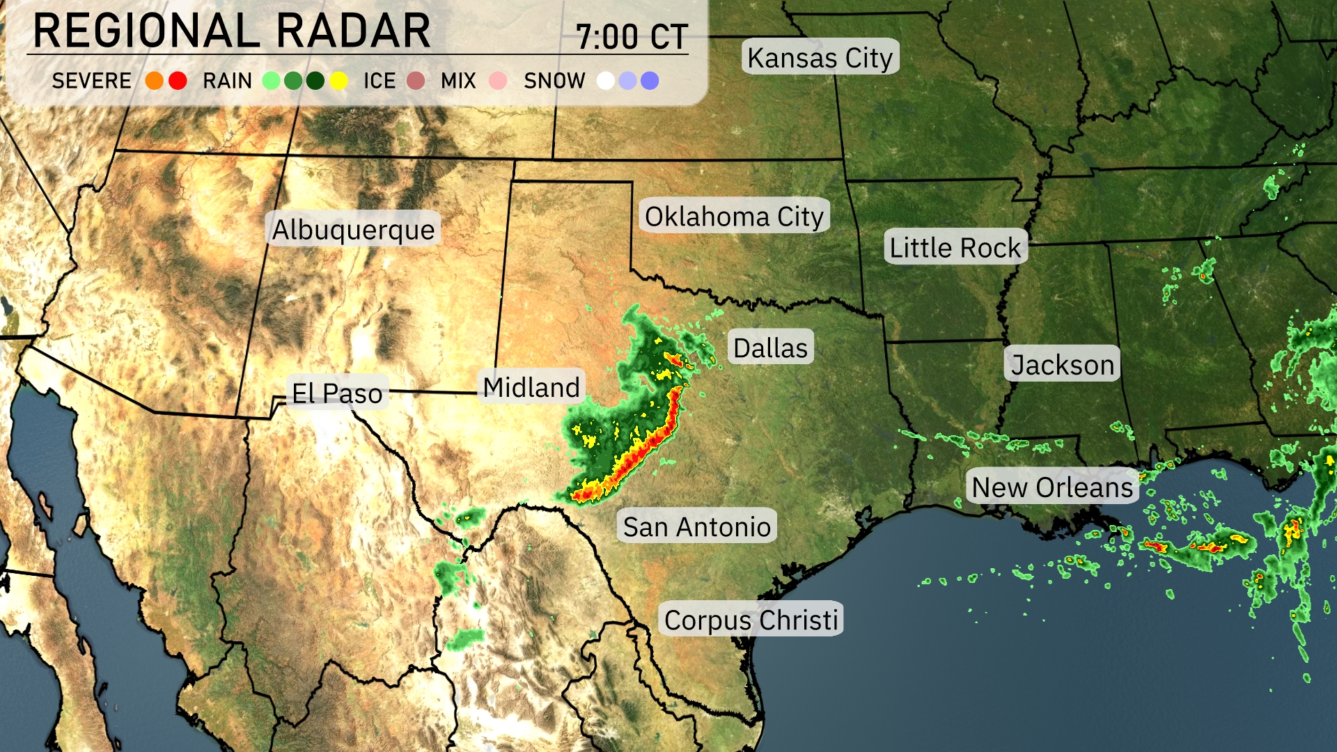
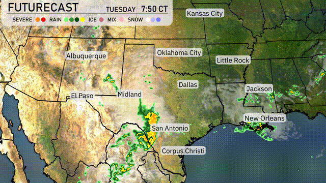
A vibrant line of storms is stretching from west to east across the Southern Plains, primarily affecting areas from Midland to San Antonio, Texas. This storm line is edging toward Dallas with increased intensity, marked by heavy rain and possibly severe weather. In the eastern sector, New Orleans is seeing consistent rainfall as the line continues to drift eastward. A steady patch of showers is present northeast of Jackson, heading toward the Alabama state line.
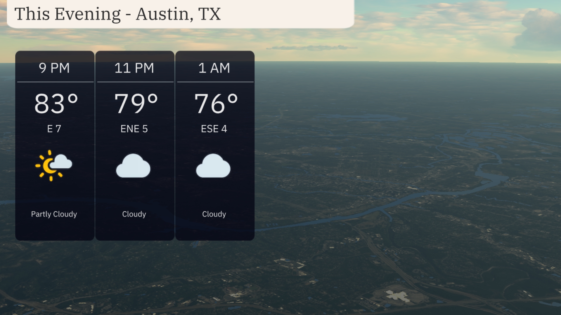
For this evening in Austin, anticipate partly cloudy skies transitioning to cloudy by 11 PM. Temperatures will start at 83 degrees at 9 PM and gradually decrease to 76 degrees by 1 AM. Winds will be gentle, shifting from east at 7 mph to east-southeast at 4 mph overnight.
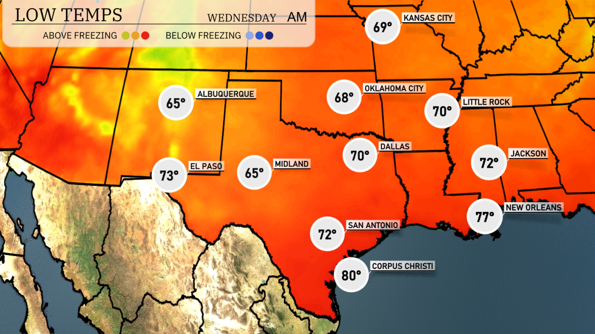
Tonight in the Southern Plains, temperatures are set to drop significantly. Dallas will see a low of 70 degrees, while Little Rock is forecasted to dip to 70 as well. Expect Midland to cool down to 65 degrees, a noticeable drop compared to earlier in the week. San Antonio will rest at 72 degrees, with New Orleans staying warmer at 77.
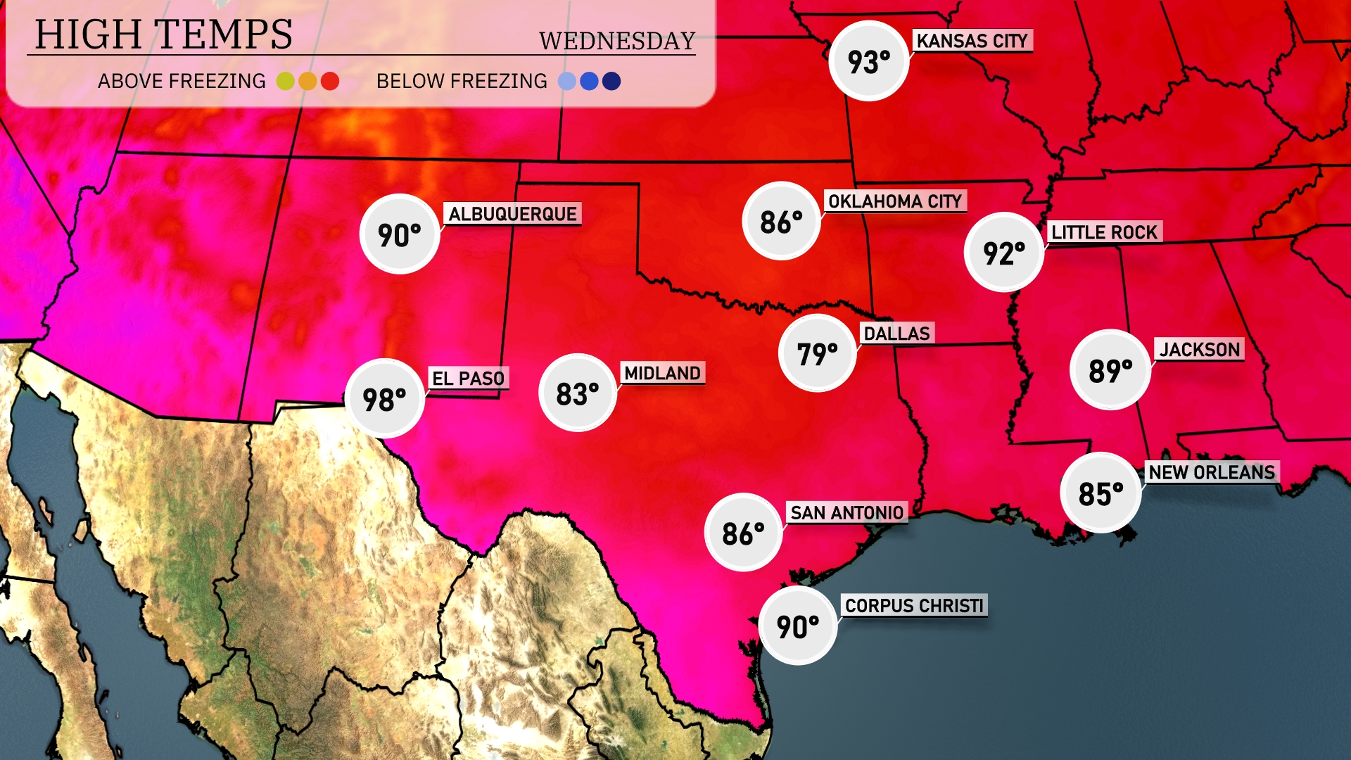
Tomorrow, El Paso is set to reach a scorching high of 98 degrees. Midland will see slightly cooler temperatures at 83 degrees. San Antonio is in for a warm day, with a high of 86 degrees. Dallas has a milder forecast, peaking at 79 degrees. Corpus Christi is expected to hit 90 degrees, reflecting above-average temperatures across the Southern Plains.
A cold front is set to move through the Southern Plains, from San Antonio to Oklahoma City, stirring up showers and thunderstorms. Expect strong storms especially near Midland and Dallas with potential for localized flooding through Tuesday night. By early Wednesday, rain spreads from Jackson to Little Rock, with gusty conditions likely. Temperatures will remain warm ahead of the front but will slightly dip once it passes.
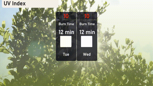
The UV index for Austin reaches a very high level of 10 on both Tuesday and Wednesday, with a burn time of just 12 minutes. It’s crucial to seek shade, apply a high-SPF sunscreen, and wear protective clothing to safeguard against sunburns.
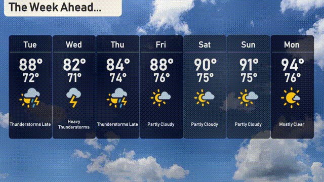
For the 7-day forecast in Austin:
Tuesday: Thunderstorms are expected late, with a high of 88 degrees and a low of 72 degrees.
Wednesday: Heavy thunderstorms move in, cooling things slightly to a high of 82 degrees and a low of 71 degrees.
Thursday: Thunderstorms continue, with temperatures around 84 degrees for the high and 74 degrees for the low.
Friday: Partial clearing brings a mix of clouds and sun, with a high of 88 degrees and a low of 76 degrees.
Saturday: Partly cloudy skies with a warm high of 90 degrees and a low of 75 degrees.
Sunday: Similar conditions with partly cloudy skies and a high reaching 91 degrees, the low at 75 degrees.
Monday: Mostly clear, wrapping up the week with a high of 94 degrees and a low of 76 degrees.