Evening Breezes and Rising Temperatures: Your Southern Plains Weather Update
By
Amy Freeze
Explore the latest weather trends across the Southern Plains from Austin to Dallas. Stay informed about the heatwaves and upcoming storms in your area.
Stay cool and informed with your Southern Plains Weather Guide! From Austin’s partly cloudy skies to imminent storms in Oklahoma City, we cover it all. Visit our blog for detailed insights and helpful tips!
As we step into another heated day across the Southern Plains, cities from Austin to Dallas are buzzing with weather changes. Austin enjoys a gentle breeze tonight with partly cloudy skies maintaining the charm. But not so far away, a storm brews over Oklahoma City. With temperatures swinging across the region, our latest blog post dives deep into what these changes mean for your daily life and how you can stay prepared. For thorough insights, visit our blog: https://amyfreeze.ai/
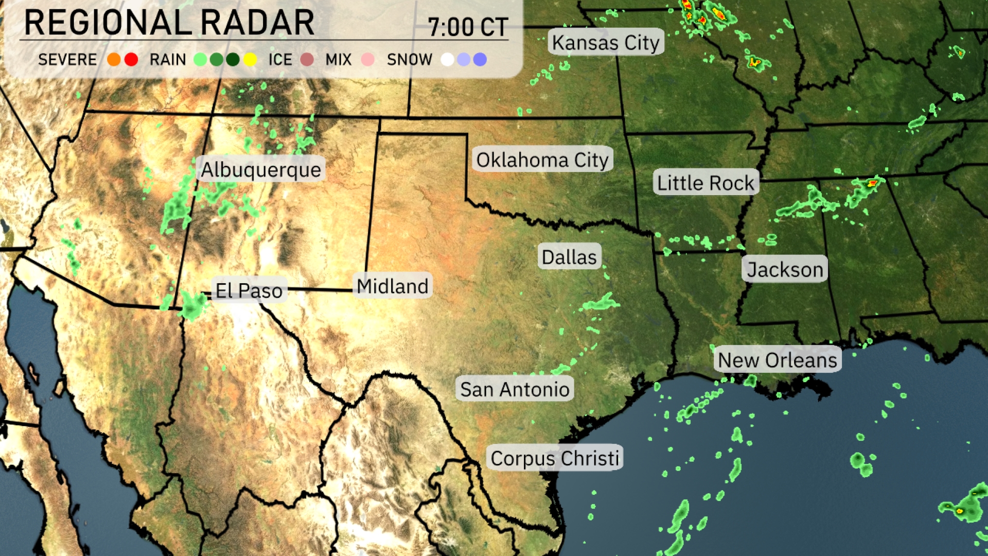
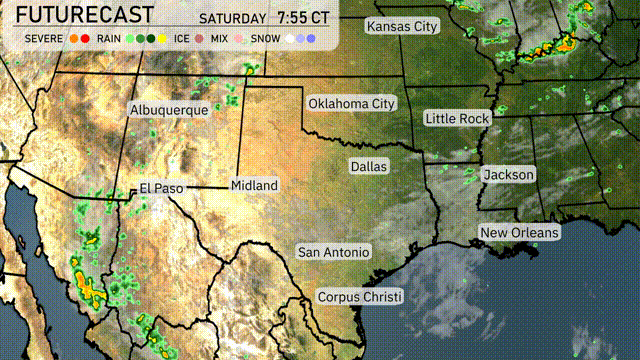
On the Regional Radar, the Southern Plains are seeing mostly calm conditions. A few showers are present around the Dallas area, with rain also noted moving through Little Rock. As you look farther north, there’s a line of storms edging into Kansas City. Cloud cover is starting to build around New Orleans and could bring some rain later.
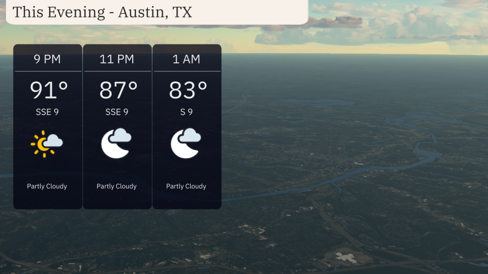
This evening in Austin, temperatures will begin at 91 degrees at 9 PM, gradually cooling to 83 degrees by 1 AM. Expect the skies to be partly cloudy, maintaining a consistent southeast wind at around 9 mph. The mild wind conditions may offer a gentle breeze, adding comfort to the slightly warm evening.
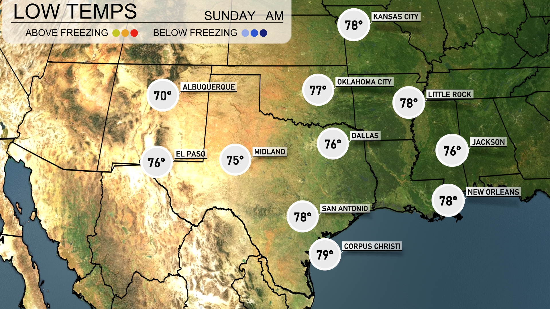
Tonight, Dallas will see temperatures drop to 76 degrees. Little Rock is expected to cool down to 78, while Oklahoma City will reach a low of 77. San Antonio will rest at 78 degrees, with Midland a bit cooler at 75.
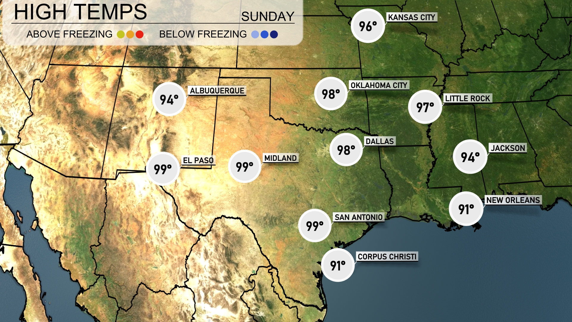
Tomorrow, temperatures will soar across the Southern Plains, with Midland and San Antonio both reaching a scorching 99 degrees. El Paso isn’t far behind, also hitting 99, while Dallas is expected to warm up to 98 degrees. Little Rock will see a high of 97, showcasing above-average readings throughout the region. New Orleans and Corpus Christi will be comparatively cooler, with highs of 91 and 91 degrees, respectively, but will still feel warm in the summer heat.
Looking ahead on the futurecast for the Southern Plains, expect a dynamic weather day. Starting with rain extending from Dallas to Corpus Christi, bringing much-needed moisture to the region. Oklahoma City could experience stronger storms due to an unstable air mass approaching with a cold front. Be alert for severe weather warnings, especially in areas like Little Rock and Jackson, through Wednesday night. Temperatures will fluctuate significantly post-storm, with a cooler and drier trend setting in for the weekend.
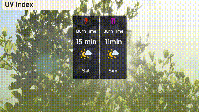
The UV index in Austin is extremely high on Saturday with a value of 9, leading to a quick burn time of 15 minutes. On Sunday, the UV index rises even higher to 11, bringing down the burn time to a mere 11 minutes.
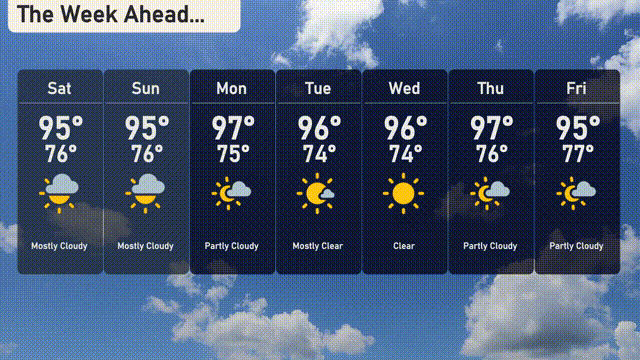
Saturday: Mostly cloudy with a high of 95 degrees and a low of 76.
Sunday: Similar conditions with mostly cloudy skies, reaching a high of 95 degrees and a low of 76.
Monday: Partly cloudy skies with temperatures climbing to 97 degrees, cooling down to 76 at night.
Tuesday: Enjoy mostly clear weather with a high of 96 degrees and a low of 74.
Wednesday: Clear skies continue with the temperature peaking at 96 degrees and a low of 74.
Thursday: Partly cloudy with temperatures reaching 97 degrees during the day and 76 overnight.
Friday: Partly cloudy again with a high of 95 degrees and a low of 77.