Weathering the Storms: A Comprehensive Guide to Southern Plains’ Weather Dynamics
By
Amy Freeze
Dive into our latest forecast with Meteorologist Amy Freeze as she discusses the serene skies of Austin and the unfolding storm systems across the Southern Plains.
Meteorologist Amy Freeze takes you through a detailed forecast of the Southern Plains, highlighting potential weather shifts and what they mean for your area.
Explore a riveting forecast by Meteorologist Amy Freeze as she unveils the weather landscape across the Southern Plains, from tranquil nights in Austin to storm-laden skies further afield. Understand the dynamics of regional weather patterns and what they spell out for residents across states from Texas to Oklahoma.
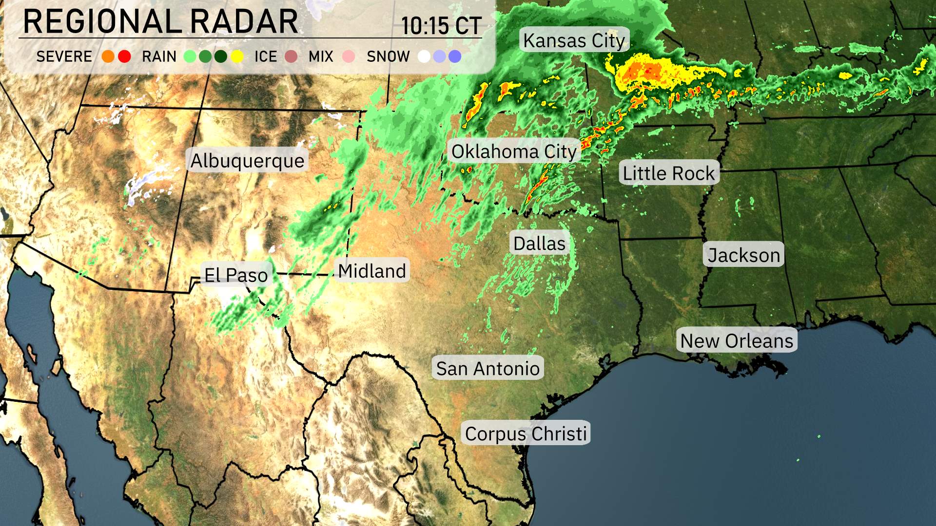
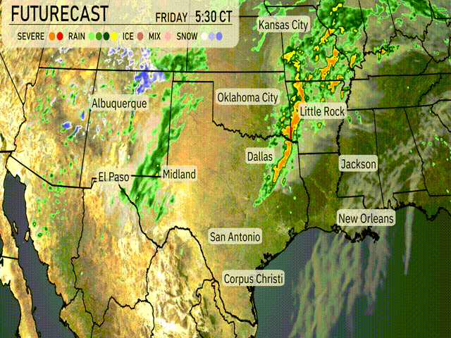
In the Southern Plains today, regional radar shows an active weather pattern unfolding. To the north, a band of thunderstorms is advancing from Oklahoma City towards Little Rock, bringing with it periods of heavy rain and potential severe conditions. The storms are expected to move farther east impacting areas like Memphis later on.
Kansas City is experiencing a mix of rain and thunderstorms, adding to the wet conditions across the region. Slightly to the south, scattered rain showers are seen over Dallas and are slowly progressing towards the east, hinting at more wet weather for the lower Mississippi Delta as these systems combine their forces.
Out west, cities such as Albuquerque and El Paso remain largely dry for now, with cloudy skies hanging overhead as light rain showers begin approaching from Midland. However, in the higher elevations along the Colorado border, light snow is continuing to fall, providing a winterlike feel in stark contrast to the more mild conditions prevailing in areas farther south, such as San Antonio and Corpus Christi.
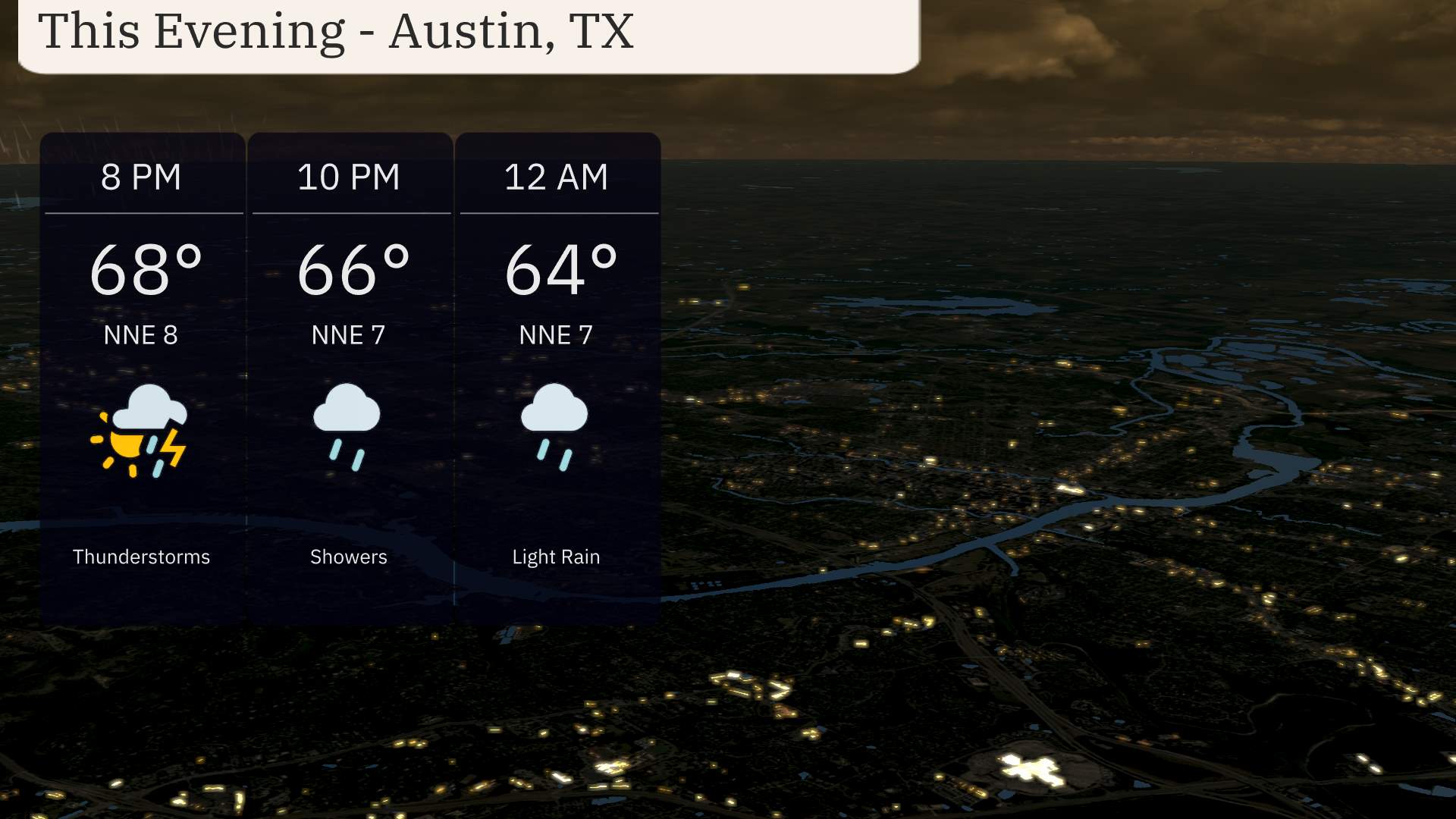
For this evening in Austin, expect a dynamic weather pattern. A thunderstorm rolls in at 8 PM with a temperature of 68 degrees and a north-northeast wind at 8 miles per hour. Showers continue at 10 PM with temperatures slightly cooling to 66 degrees, while winds maintain a steady pace from the north-northeast at 7 miles per hour. By midnight, light rain persists as temperatures further ease to 64 degrees. Keep an umbrella handy if you’re out and about tonight, as wet conditions are expected to linger.
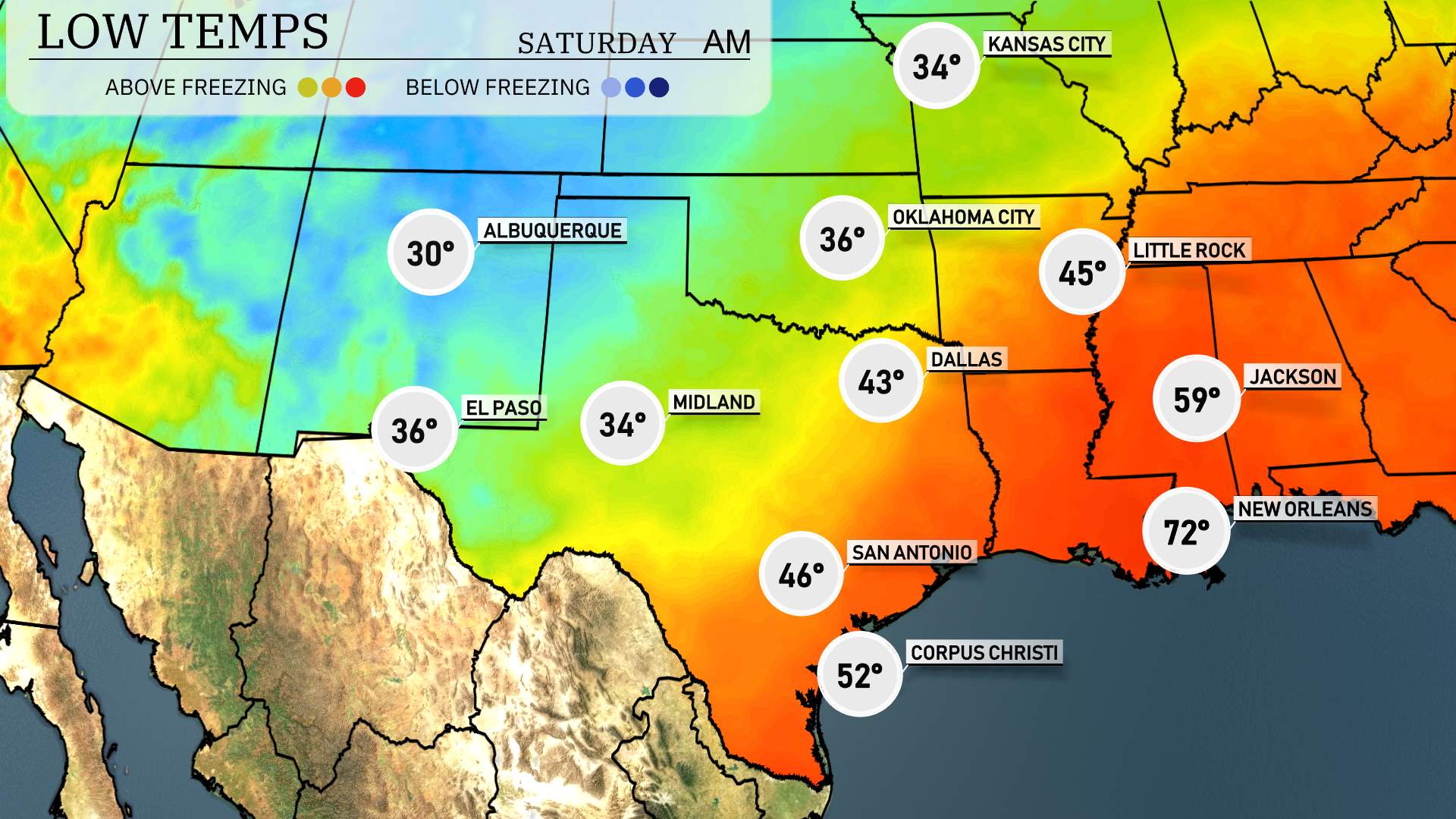
Low temperatures tonight in the Southern Plains are dipping significantly. In the Oklahoma City area, expect a chilly low of 36 degrees. Dallas will see a low of 43, while Little Rock braces for colder air with a low of 45. Heading southwest, Midland is forecasted to drop to 34 degrees and El Paso will be slightly warmer at 36. San Antonio will see lows around 46, indicating a noticeable shift in temperatures across the region.
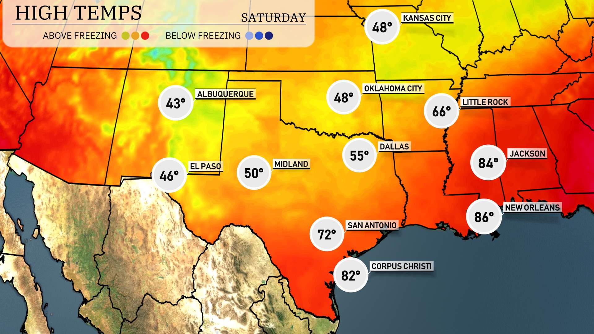
For tomorrow in the Southern Plains, high temperatures are looking favorable, aligning closely with seasonal averages.
In El Paso, expect a high of 74 degrees, while Midland will see much warmer conditions with temperatures reaching 85 degrees. San Antonio is forecasted for a pleasant 81 degrees, and Corpus Christi will enjoy a high of 79 degrees. Dallas will be slightly cooler at 67 degrees, and Kansas City is anticipated to sit at 61 degrees.
Overall, the region is expected to experience more mild temperatures driven by clear conditions. This trend points towards a comfortable day ahead for residents in these key cities.
A cold front shifts into the Southern Plains tomorrow, impacting areas primarily from Dallas to Oklahoma City with a potential for severe thunderstorms, including heavy rainfall and damaging winds. As this front moves eastward, stay aware of weather warnings, particularly around Little Rock where the thunderstorm threat is pronounced. Rain showers will expand, offering beneficial moisture from San Antonio to Corpus Christi. Meanwhile, regions farther west like Albuquerque and Midland will experience lighter, sporadic showers. Be prepared for potential travel disruptions due to storm activity and hazardous windy conditions across the plains.
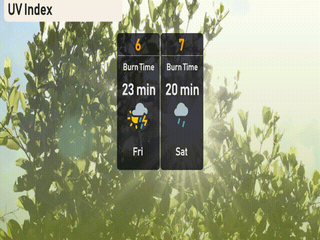
The UV index in Austin will be a high of 7 on Saturday, making sun protection essential. Expect a burn time of about 20 minutes in direct sunlight! On Friday, the UV index is moderate at 6, with storms potentially affecting exposure, so the burn time could be around 23 minutes when the clouds clear. Stay safe and enjoy your day!
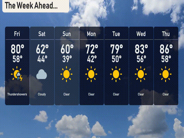
Here’s the 7-day forecast for Austin:
Friday: Thunderstorms expected with a high of 80 degrees and a low of 58 degrees.
Saturday: Cloudy conditions with temperatures dropping to a high of 62 degrees and a low of 44 degrees.
Sunday: Clear skies with the temperature reaching 60 degrees and a low of 39 degrees.
Monday: Another clear day, warming up to 72 degrees during the day and cooling to 42 degrees at night.
Tuesday: Clear skies continue, with a high of 79 degrees and a low of 50 degrees.
Wednesday: Staying clear and warmer, hitting a high of 83 degrees and a low of 56 degrees.
Thursday: Clear and getting warmer with a high of 86 degrees and a low of 58 degrees.
Hope that helps!