Clear Skies and Stormy Nights: The Comprehensive Southern Plains Weather Guide
By
Amy Freeze
Dive into a detailed analysis of the ever-changing weather patterns across the Southern Plains. From Texas heat to unexpected snow in New Mexico, meteorologist Amy Freeze covers it all.
Meteorologist Amy Freeze guides you through a mixed bag of weather conditions across the Southern Plains. Stay ahead with thorough insights on what to expect in your city!
Welcome to your detailed weather update for the Southern Plains, brought to you by Amy Freeze. Today, we’re covering a range of conditions from Austin’s partly cloudy skies to heavy snow along Colorado’s southern border. We’ll discuss temperature trends, upcoming storms, and safety tips for severe weather. For city-specific forecasts and more, visit https://amyfreeze.ai/.
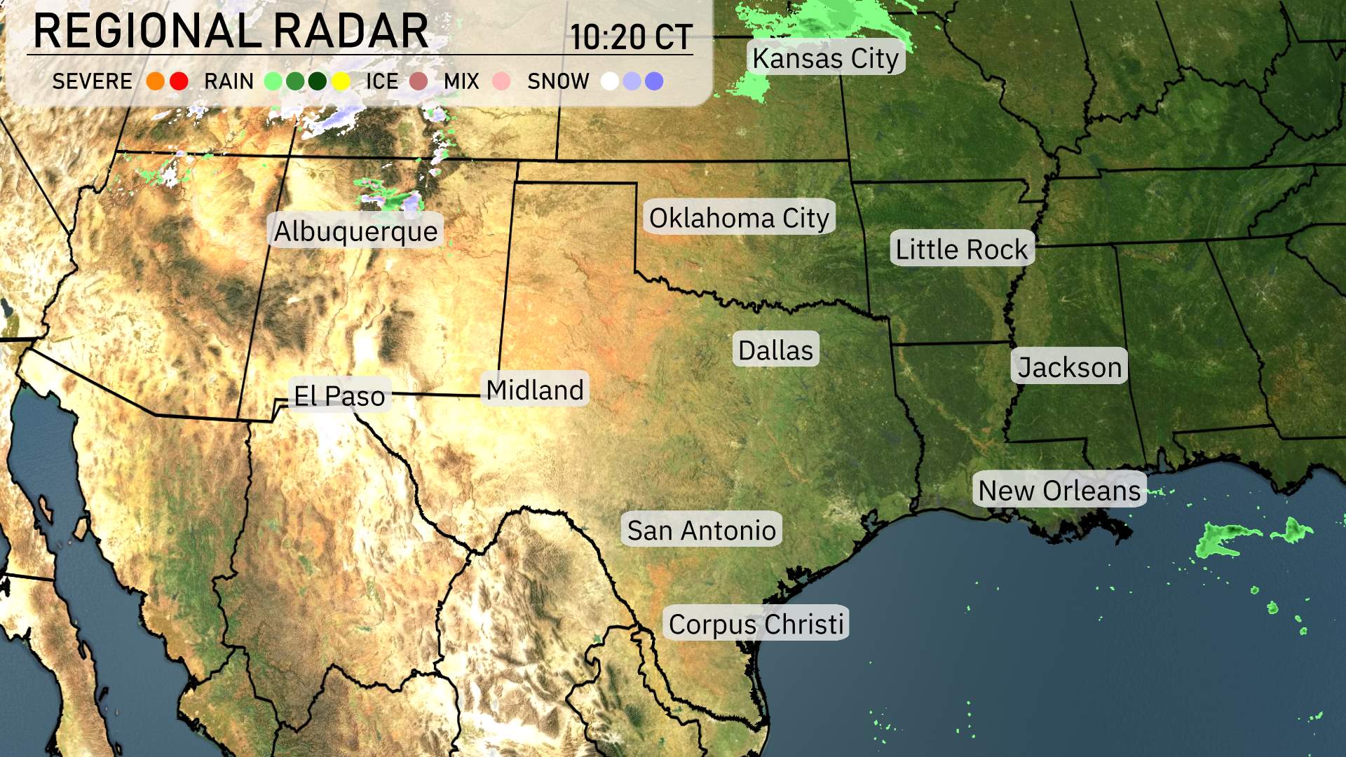
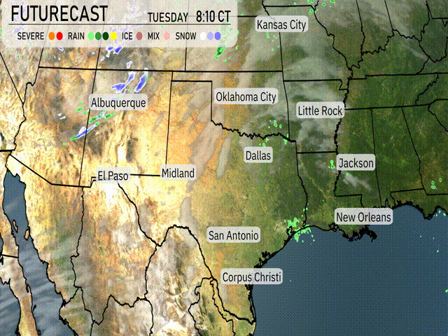
Across the Southern Plains, today’s regional radar shows a mix of weather conditions.
The panhandle of Oklahoma is seeing a few scattered rain showers, while the majority of Texas, including cities like Dallas, San Antonio, and Midland, remains dry. Cloud cover is creeping in from the west, suggesting a shift in weather patterns later in the day.
Moving eastward, rain is developing over the Mississippi Delta, impacting areas around Jackson and shifting towards the east. The Gulf Coast near New Orleans is currently free of precipitation, enjoying a calm weather pattern for the time being. And even on this April first, northern New Mexico, including areas near Albuquerque, is experiencing light snow showers, adding a wintery feel to the higher elevations. Farther north into Colorado, heavier snow is falling along the southern border, with potential gusts in the mountain passes reaching up to 75 miles per hour.
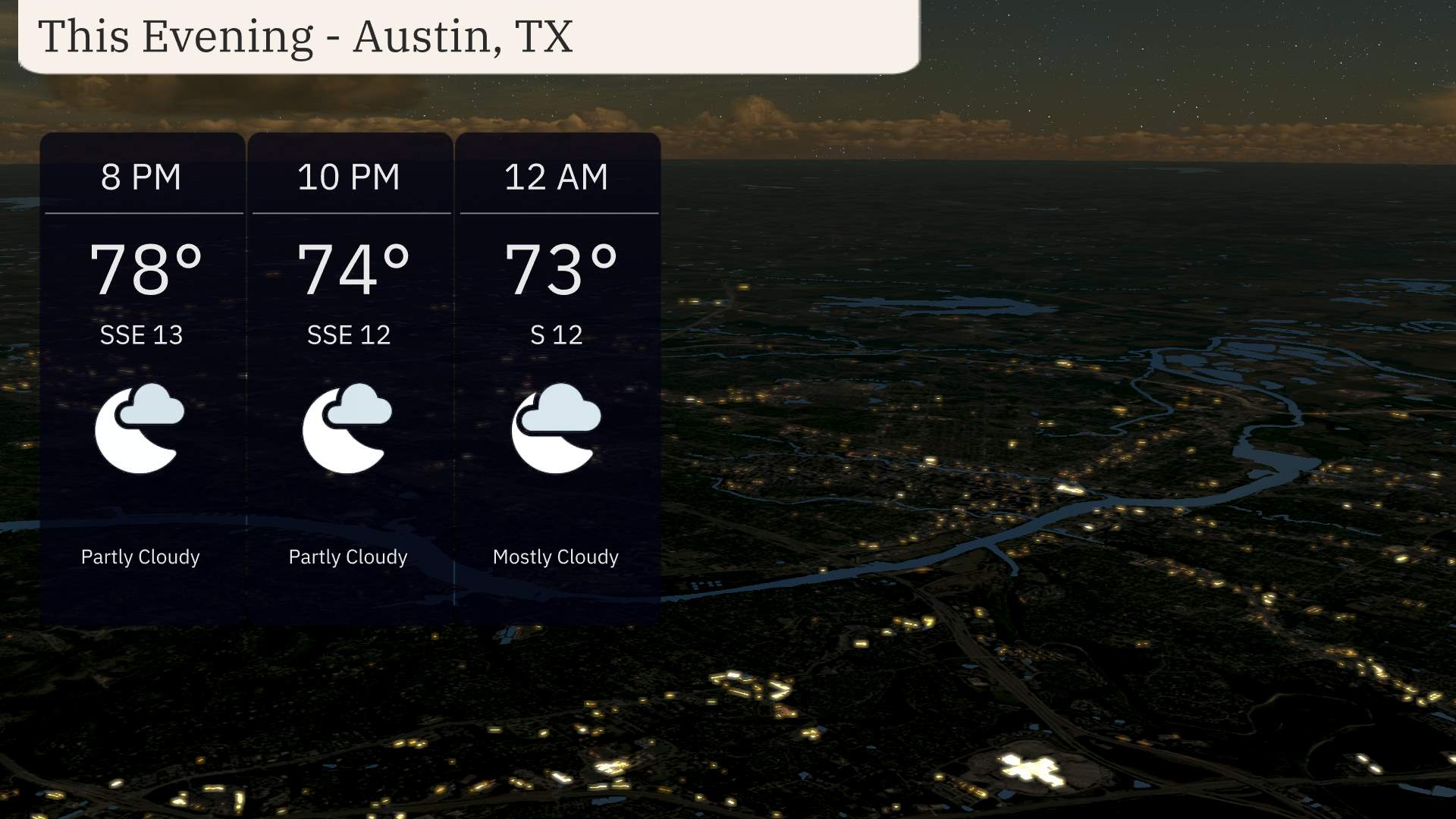
Temperatures in Austin this evening begin at 78 degrees by 8 PM, gradually cooling to 73 degrees by midnight. Expect partly to mostly cloudy skies with a steady south-southeast breeze at 13 miles per hour, decreasing slightly as the night progresses. Cloud cover will increase as the evening continues.
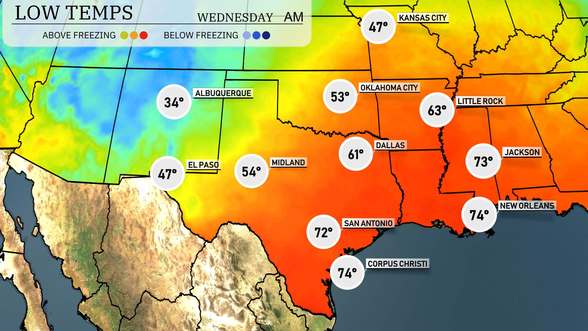
Tonight in the Southern Plains, we’re seeing some significant drops in temperatures as cooler air moves in.
Oklahoma City will dip down to around 40 degrees, while Norman is expected to see a low of 39. In Texas, Dallas will reach 43 degrees, and Fort Worth will fall to 42. In the Panhandle, Amarillo will see a chilly 37 degrees.
Heading south, San Antonio is looking at a more mild 56 degrees, while both Austin and Houston will stay warmer, around 57 and 58 degrees respectively.
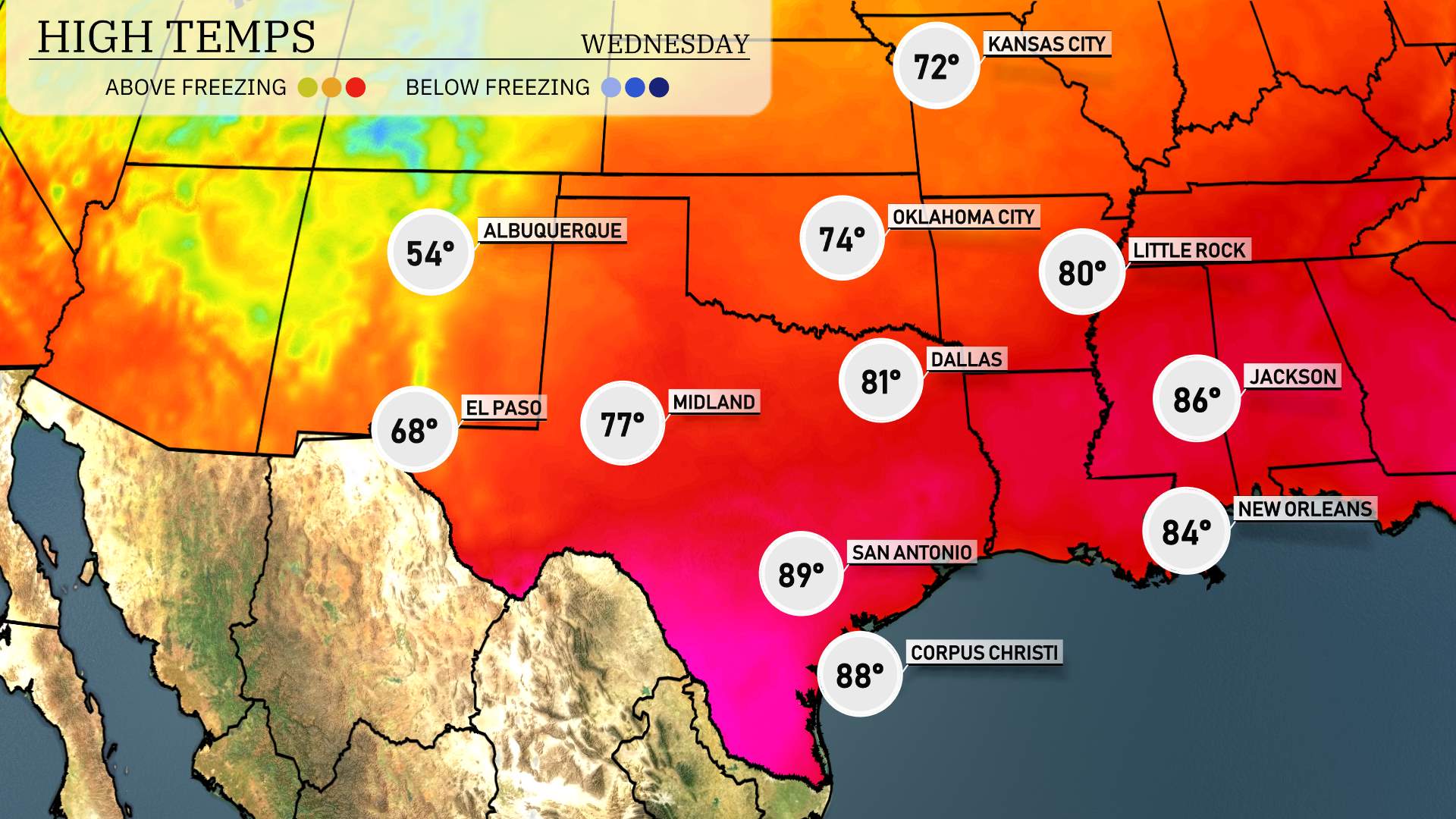
High temperatures for tomorrow in the Southern Plains are looking quite warm and seasonable. In El Paso, expect a high of 68 degrees. Midland warms up nicely with temperatures reaching 77 degrees. San Antonio will enjoy a balmy high of 89 degrees, while Corpus Christi is forecasted to hit 88 degrees. Dallas sees a more moderate high of 81 degrees, and Kansas City will be cooler at 72 degrees.
Anticipate a mix of weather across the Southern Plains tomorrow. A cold front will push through, bringing a chance of severe weather, particularly in southern Oklahoma and northern Texas. Be prepared for strong thunderstorms capable of producing heavy rainfall and gusty winds, especially around Oklahoma City. Farther south, from San Antonio to Corpus Christi, expect rain showers that could add some much-needed moisture to the region. As the cold front progresses, watch for potential weather warnings and shifts in conditions through Wednesday night.
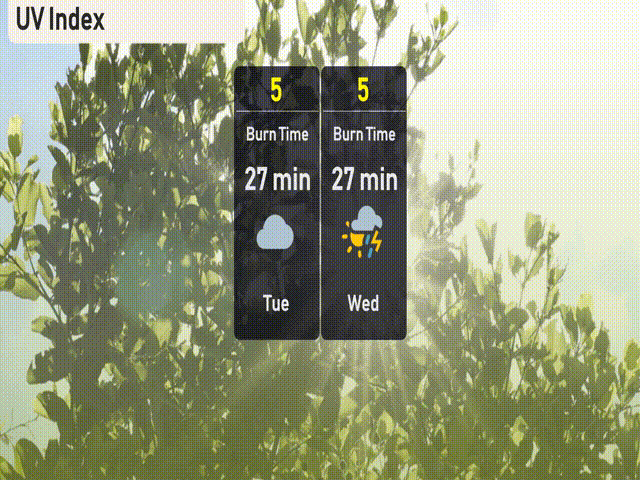
The UV index in Austin is showing a moderate level of 5 for both Tuesday and Wednesday, with a burn time of about 27 minutes in direct sunlight. Keep your sunscreen handy and consider protective clothing if you plan to be outdoors. Remember, clouds and potential storms might offer occasional relief, but sun protection remains crucial!
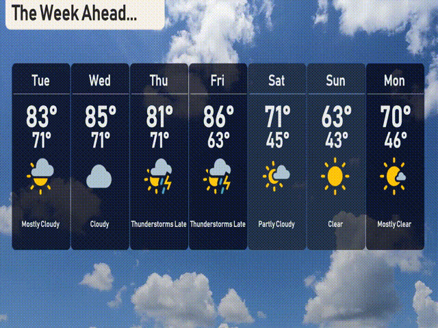
Here’s the 7-day forecast for Austin:
Tuesday: Mostly cloudy skies with a high of 83 degrees and a low of 71.
Wednesday: Clouds persist with the high nearing 85 degrees, and temperatures dropping to 71 at night.
Thursday: Thunderstorms roll in late, with the high reaching 81 degrees and the low at 71.
Friday: Brace for more thunderstorms, with temperatures peaking at 86 degrees, cooling to 63 at night.
Saturday: A break in the weather as it turns partly cloudy, with a high of 71 degrees and a low of 45.
Sunday: Clear skies take over, making for a cooler day with a high of 63 degrees and an overnight low of 43.
Monday: Mostly clear conditions with a warming trend; expect a high of 70 degrees and a low of 46.