Clear Nights and Chilly Bites: Navigating the Southwest’s Spring Weather with Amy
By
Amy Freeze
Explore the diverse weather patterns across the Southwest with Amy Freeze. From the clear, starry nights of Phoenix to the rainy relief of San Francisco, get all your weather wisdom in one place!
Meteorologist Amy Freeze guides you through the fluctuating weather of the Southwest, from Phoenix’s pleasant evenings to Flagstaff’s snowy surprises. Discover how these conditions could affect your plans in our latest blog post!
Join Amy Freeze as she details this week’s weather across the Southwest. Learn about Phoenix’s partly cloudy skies and notable UV levels, along with a full seven-day forecast that promises warming trends. From chilly nights in Ely to rain in Northern California, we’re covering every angle to prepare you for the week ahead. Find out more at https://amyfreeze.ai/
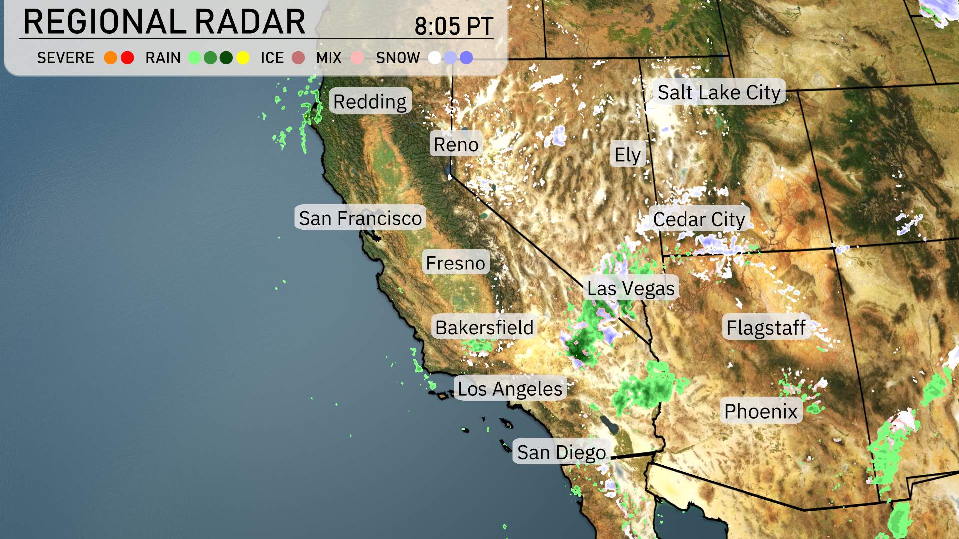
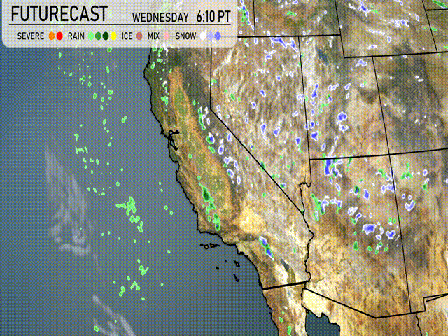
The Southwest region is currently experiencing diverse weather patterns. Along the California coast, showers are advancing inland from the Pacific Ocean, providing much-needed precipitation in areas like San Francisco and Fresno. Rain is also spreading into the central valleys, delivering relief while higher elevations see snowfall.
Low clouds have spread into southern sections like Los Angeles, where light drizzle is occurring today. Farther to the east around Flagstaff, the chill of spring brings with it a chance for light snow showers.
Nevada’s desert city Las Vegas is seeing dry conditions as well, with clear skies extending to the southeastern parts of the state. Across the Utah border, Cedar City encounters overcast skies, but precipitation stays primarily to the west.
In the larger Southwestern area, a mix of rain and snow is hitting places like Salt Lake City where conditions remain unsettled amidst colder air. The radar shows a patchy mix across higher terrains, but Phoenix remains largely dry with a mix of clouds and sunshine, indicating calm weather.
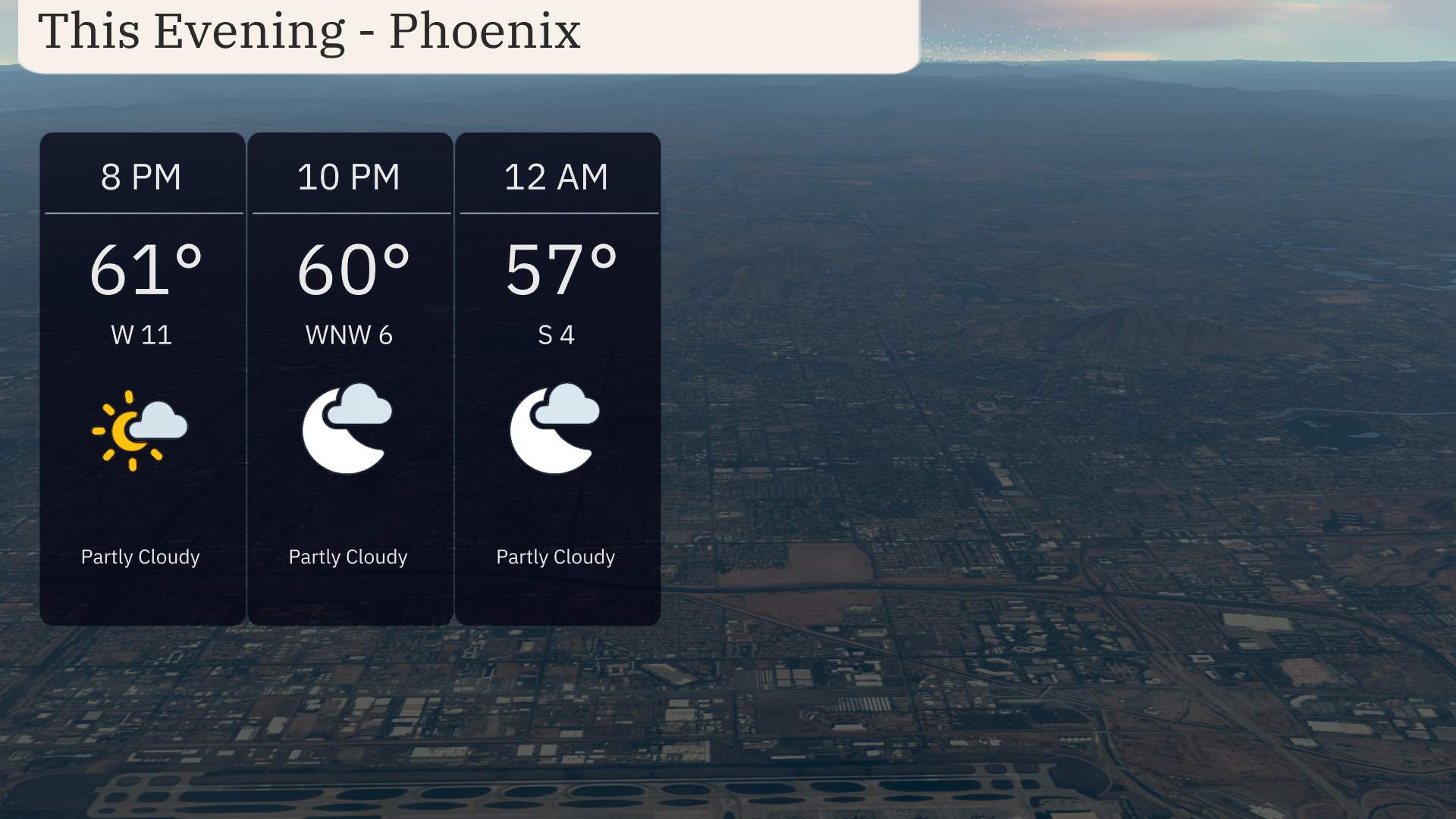
For this evening in Phoenix, expect partly cloudy skies with temperatures gradually decreasing from 61 degrees at 8 PM to 57 degrees by midnight. Winds will shift from 11 miles per hour out of the west at 8 PM to 4 miles per hour out of the south by midnight.
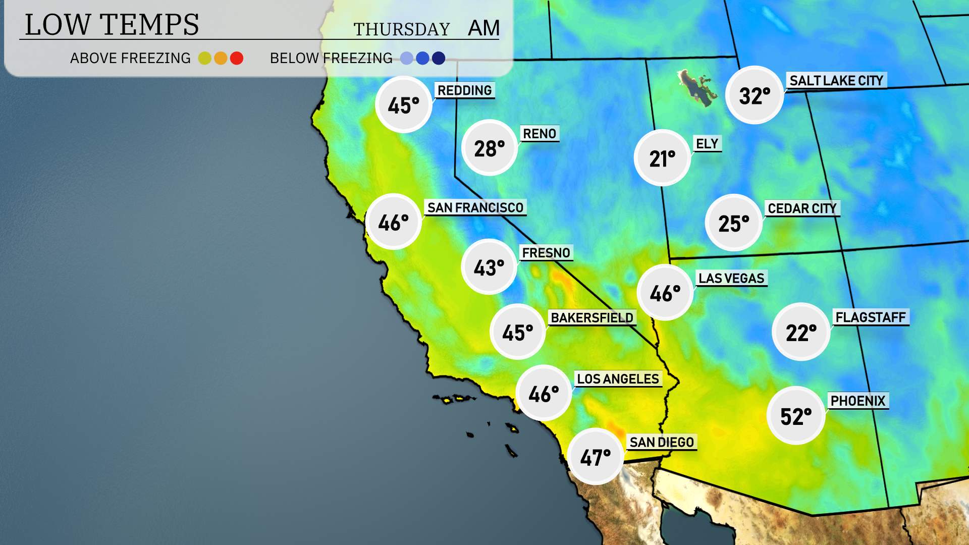
Low temperatures tonight in the Southwest are making headlines with notably chilly air. Ely is dropping to a brisk 21 degrees, while Cedar City will see a low of 25. Flagstaff isn’t far behind with temperatures hitting 22 degrees. Las Vegas rounds out the cooler spots at 46 degrees, a drop that feels significant compared to recent nights. Over in Phoenix, it will be a much warmer night at 52 degrees.
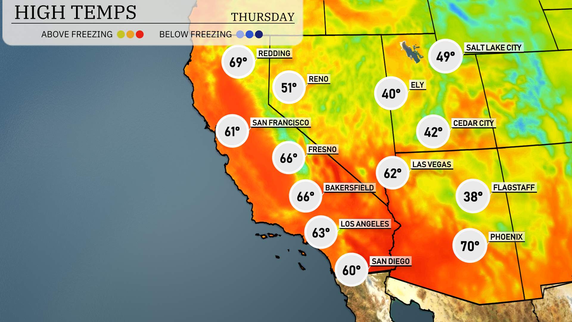
Tomorrow in the Southwest, we’re looking at some notably high temperatures as a ridge of high pressure settles in.
Las Vegas is also expected to enjoy a pleasant day with highs around 62 degrees, which is quite mild for early April.
Moving farther west, Bakersfield and Fresno will see highs reaching 66 degrees, well within the seasonal range. San Diego is forecasted for a cooler high of 60 degrees, while Los Angeles will hit 63 degrees, slightly below average as the coastal influence keeps temperatures in check.
To the north, San Francisco can expect a high of 61 degrees, while Redding warms to 69 degrees, benefiting from slightly clearer conditions.
Expect a dynamic day in the Southwest region with a strong weather pattern shifting. Northern California will see consistent waves of valley rain from late tonight into tomorrow, potentially causing tricky travel conditions. In Southern California, the San Bernardino Valley should prepare for more rain with possible heavy downpours, leading to slick roads through the mountain passes. The desert areas will remain mostly clear and sunny, but the coastal and northern regions shouldn’t let their guard down as these precipitation events unfold.
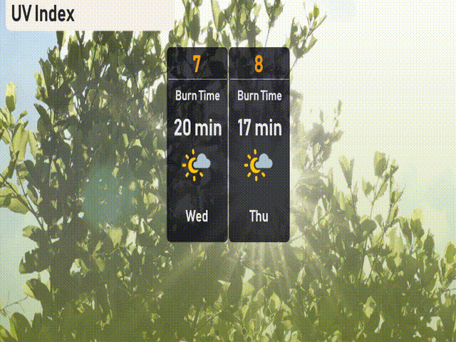
Phoenix is set to experience high UV levels, reaching an index of 7 today, with a burn time around 20 minutes, so be sure to cover up and apply sunscreen. On Thursday, the UV index climbs to 8.
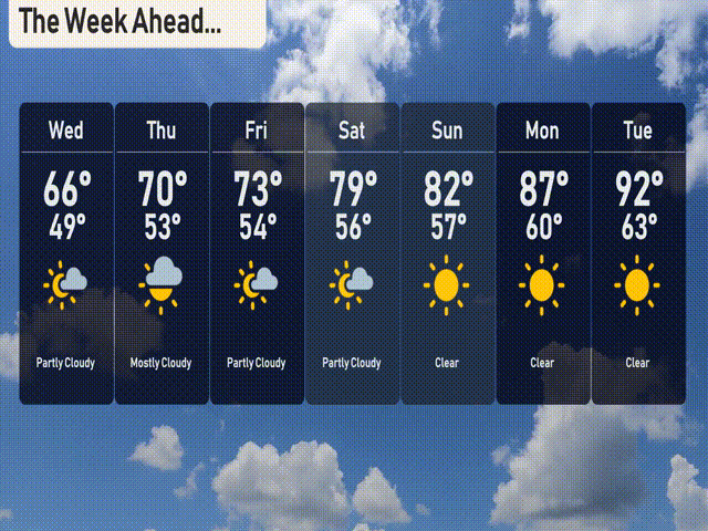
For the Phoenix 7 Day Outlook, here’s what you can expect:
Wednesday: Partly cloudy with a high of 66 degrees and a low of 49.
Thursday: Skies turn mostly cloudy with temperatures rising to 70 degrees and dropping to 53 overnight.
Friday: Anticipate partly cloudy conditions with a daytime high of 73 degrees and a low of 54.
Saturday: A beautiful day ahead—partly cloudy with warming temperatures reaching 79 degrees, and a low of 56.
Sunday: Enjoy clear skies with temperatures peaking at 82 degrees and a pleasant low of 57 in the evening.
Monday: Clear and sunny to start the week with a high around 87 degrees and cooling to 60 at night.
Tuesday: The warm-up continues under clear skies with a high of 92 degrees and a low of 63.