Southwest Weather Rollercoaster: From Sunny Skies to Snow Showers
By
Amy Freeze
Meteorologist Amy Freeze describes a dramatic blend of weather conditions across the Southwest, from Arizona’s mild days to Nevada's chilly nights. Stay informed on what to expect right outside your front door.
From sparkling sunshine in Phoenix to snowflakes in Flagstaff, meteorologist Amy Freeze covers the extensive range of weather conditions expected across the Southwest. Read more about your local weather forecast!
Greetings from your favorite weather anchor, Amy Freeze! In this comprehensive post, we’ll dive into the diverse climate patterns across the Southwest. Discover what brings sunny days to Phoenix, chilly nights to Ely, and consistent showers to Northern California. Along with daily temperature insights, get a 7-day forecast exclusively for Salt Lake City. Dive into how fluctuating weather conditions could affect your daily plans and health.
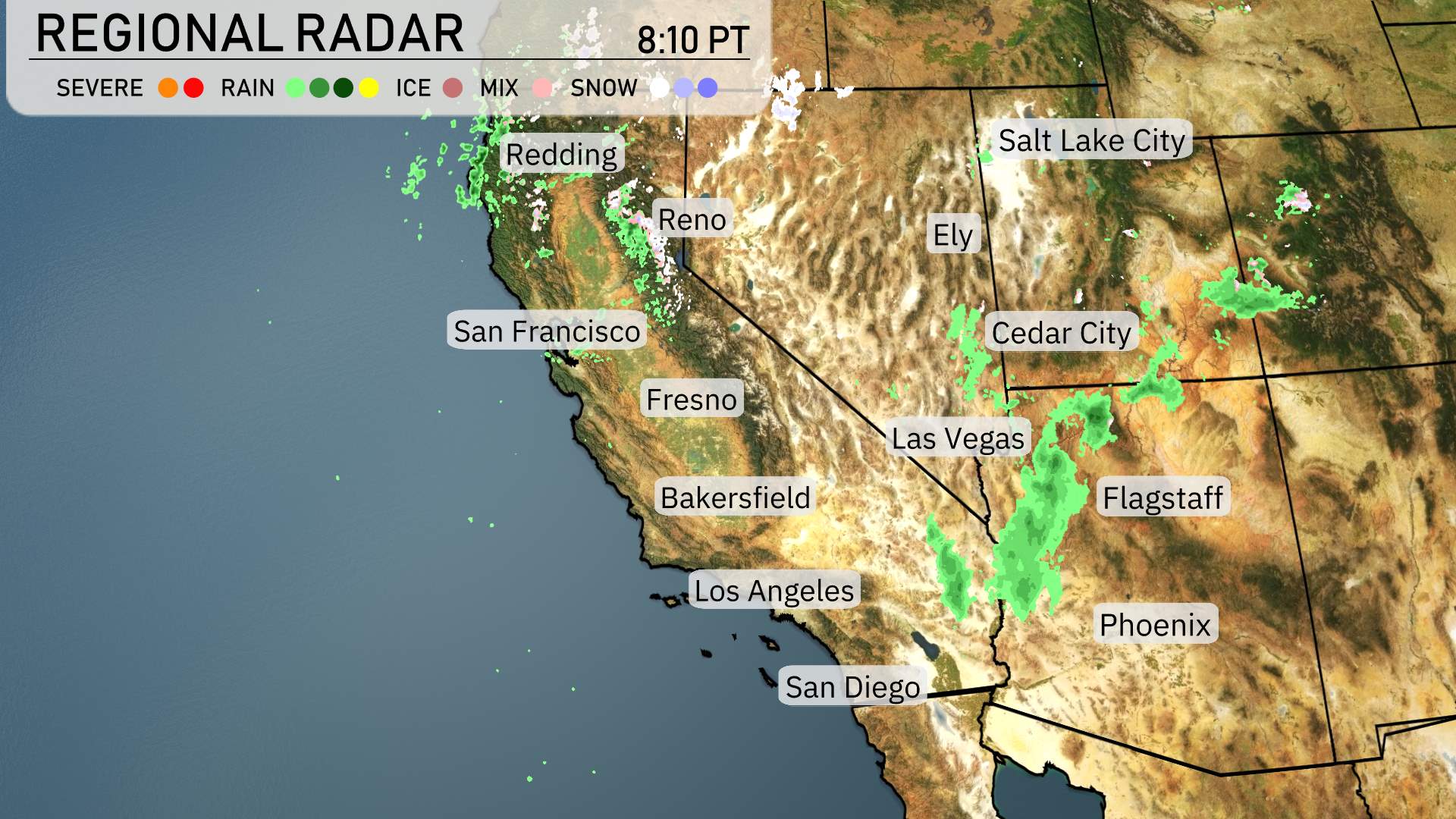
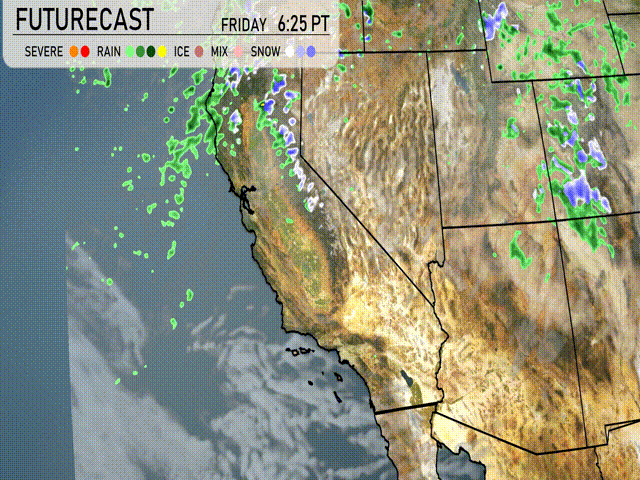
On the regional radar, rain is pushing eastward from the Pacific Ocean, bringing much-needed moisture to parts of the Southwest. Redding, in Northern California, is experiencing light rain showers that are spreading into the surrounding areas. The foothills near Reno are also seeing some precipitation, with rain likely transitioning to snow at higher elevations.
Farther south, rain showers are persisting along the Central Valley near Fresno and Bakersfield, providing some relief from ongoing dry conditions. Cedar City is contending with a mix of rain and snow, thanks to the cooler air at higher altitudes.
In Arizona, Flagstaff is lightly dusted by snow showers, creating a crisp, wintry atmosphere. On the other hand, Phoenix is staying dry with relatively clear skies. Las Vegas, too, enjoys dry conditions, making it a perfect evening for outdoor activities.
Down in Southern California, Los Angeles and San Diego remain mostly dry with a few scattered clouds lingering in the area.
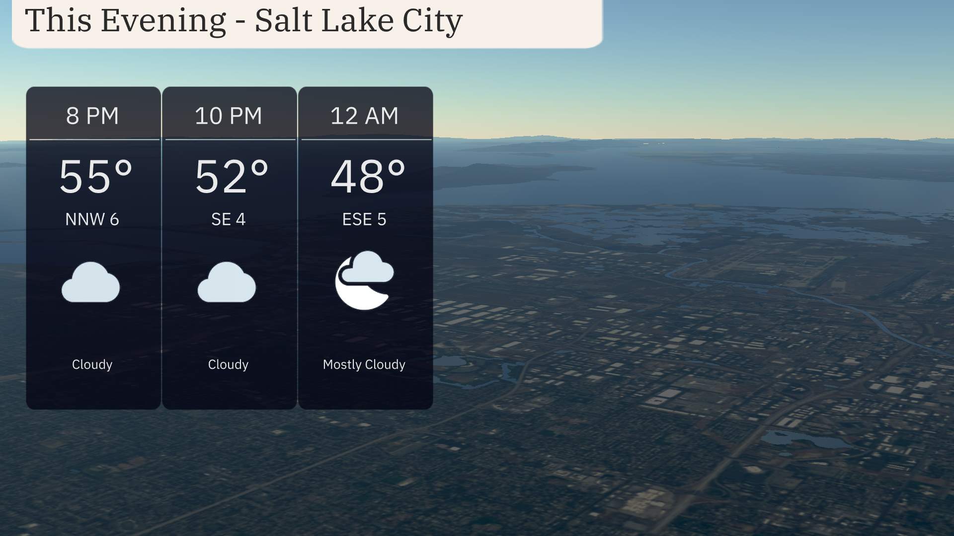
In Salt Lake City this evening, temperatures are set to start at 55 degrees by 8 PM, gradually cooling to 48 degrees by midnight. The sky remains cloudy through the evening, transitioning to mostly cloudy by midnight. Winds shift direction from the northwest at 6 MPH and turn east-southeast at 4 MPH, finally settling east-southeast at 5 MPH.
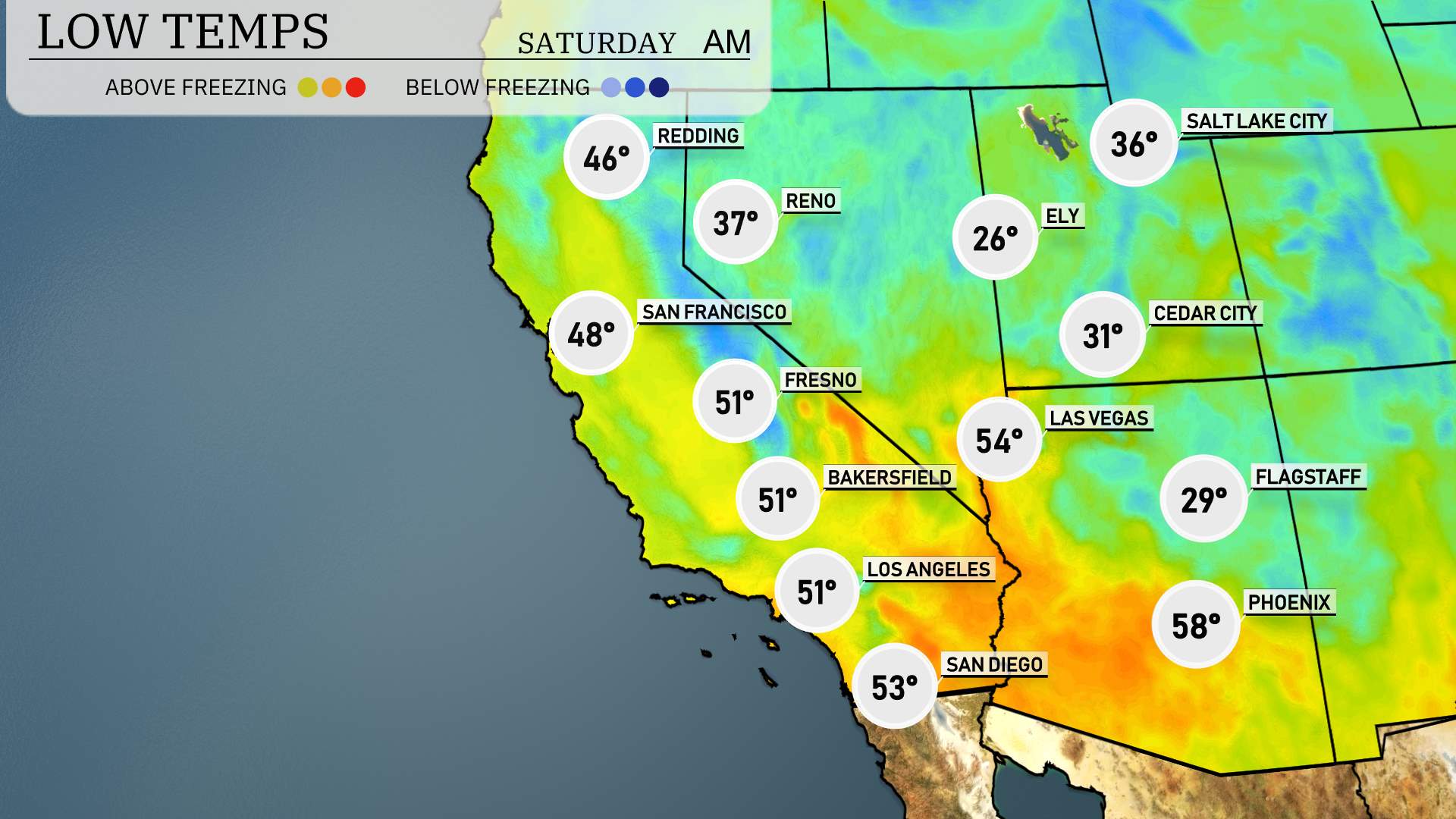
Tonight in the Southwest region, we’re looking at some notable low temperatures. Ely, Nevada, will be one of the coldest spots at a brisk 26 degrees. Flagstaff, Arizona, is also expecting a chilly night with a low of 29 degrees. Meanwhile, Cedar City will dip to 31 degrees. Las Vegas stays relatively mild with a low of 54 degrees. Moving to California, San Francisco will see a low of 48 degrees, while Fresno and Bakersfield will both drop to 51 degrees. Los Angeles is expecting a pleasant 51 degrees and San Diego will wrap up the night at a mild 53 degrees.
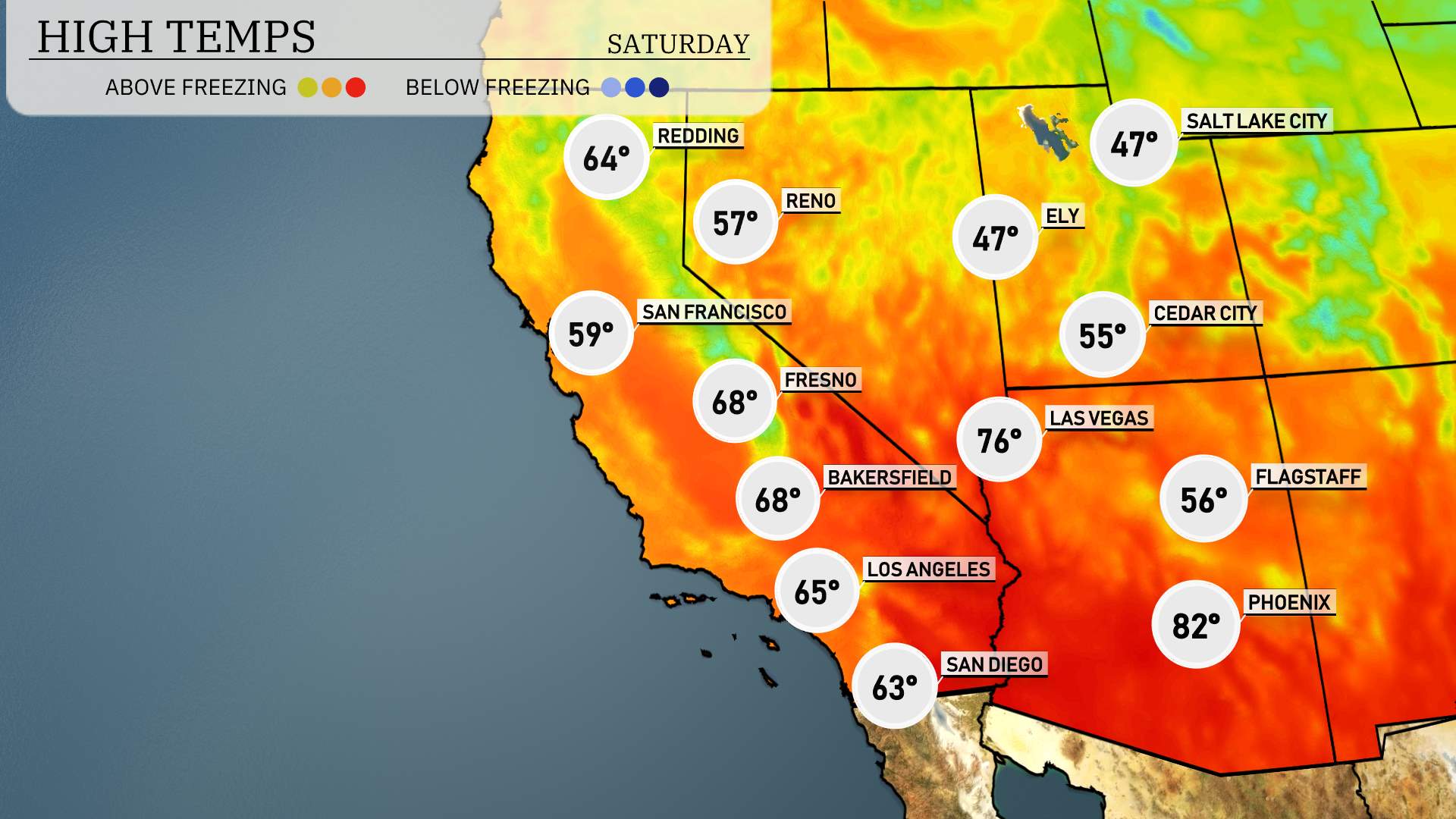
High temperatures for the Southwest region tomorrow are shaping up to be on the warmer side, with some areas reaching well above average.
In Phoenix, expect a high of 82 degrees, which is notably warm for this time of year. Las Vegas is heating up as well, anticipating a high of 76 degrees. Heading towards California, Los Angeles will enjoy a mild day with a high of 65 degrees. Bakersfield is also on track for a pleasant 68 degrees.
Moving further north, Fresno records a similar high of 68 degrees. San Diego will be slightly cooler at 63 degrees. In contrast, coastal cities like San Francisco will see a high of 59 degrees and Redding at 64 degrees.
The Southwest is set for an active weather system over the next 48 hours. Expect several rounds of rain to impact Northern California, moving in from the coast. Southern California, particularly the San Bernardino Valley, should brace for an additional wave of showers with locally heavy rainfall. This will lead to tricky driving conditions in the mountain passes. Farther inland, dry weather prevails, providing a sharp contrast to the coastal moisture.
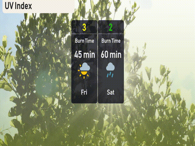
The UV index in Salt Lake City is low today and will not be significant based on cloud cover and potential rain, which are reducing UV exposure.
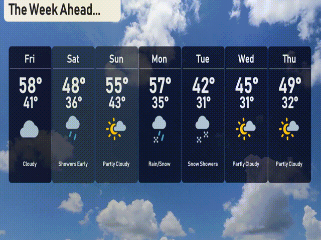
For the 7-day forecast in Salt Lake City:
Friday: Cloudy with a high of 58 degrees and a low of 41.
Saturday: Showers early, cooling down to a high of 48 degrees and a low of 36.
Sunday: Warming up with partly cloudy skies, reaching a high of 55 degrees with a low of 43.
Monday: Rain and snow mix, temperatures will peak at 57 degrees and drop to 35.
Tuesday: Snow showers expected, with a daytime high of 42 degrees and a nighttime low of 31.
Wednesday: Partly cloudy with the temperature reaching 45 degrees during the day and 31 degrees at night.
Thursday: Continued partly cloudy, with a high of 49 degrees and a low of 32.
Hope that helps! Stay safe!