From Clear Skies to Stormy Nights: Navigating This Week’s Weather Wonders in the Southwest
By
Amy Freeze
Meteorologist Amy Freeze takes you on a tour of the Southwest's varying climates, from drizzles in L.A. to snowfalls in Flagstaff.
Meteorologist Amy Freeze provides a lively update on the diverse weather conditions across the Southwest, including clear nights in Salt Lake City.
Welcome to your detailed Southwest weather guide by Amy Freeze! This week, explore a symphony of conditions from snow-capped mountains in Sierra Nevada to gentle drizzles in Los Angeles. With a mix of weather across regions including Salt Lake City and California’s coast, this update ensures you’re prepared, whether you’re planning a serene evening at home or adventurous outdoor activities. Bundle up, stay dry, or catch some rays depending on your locale!
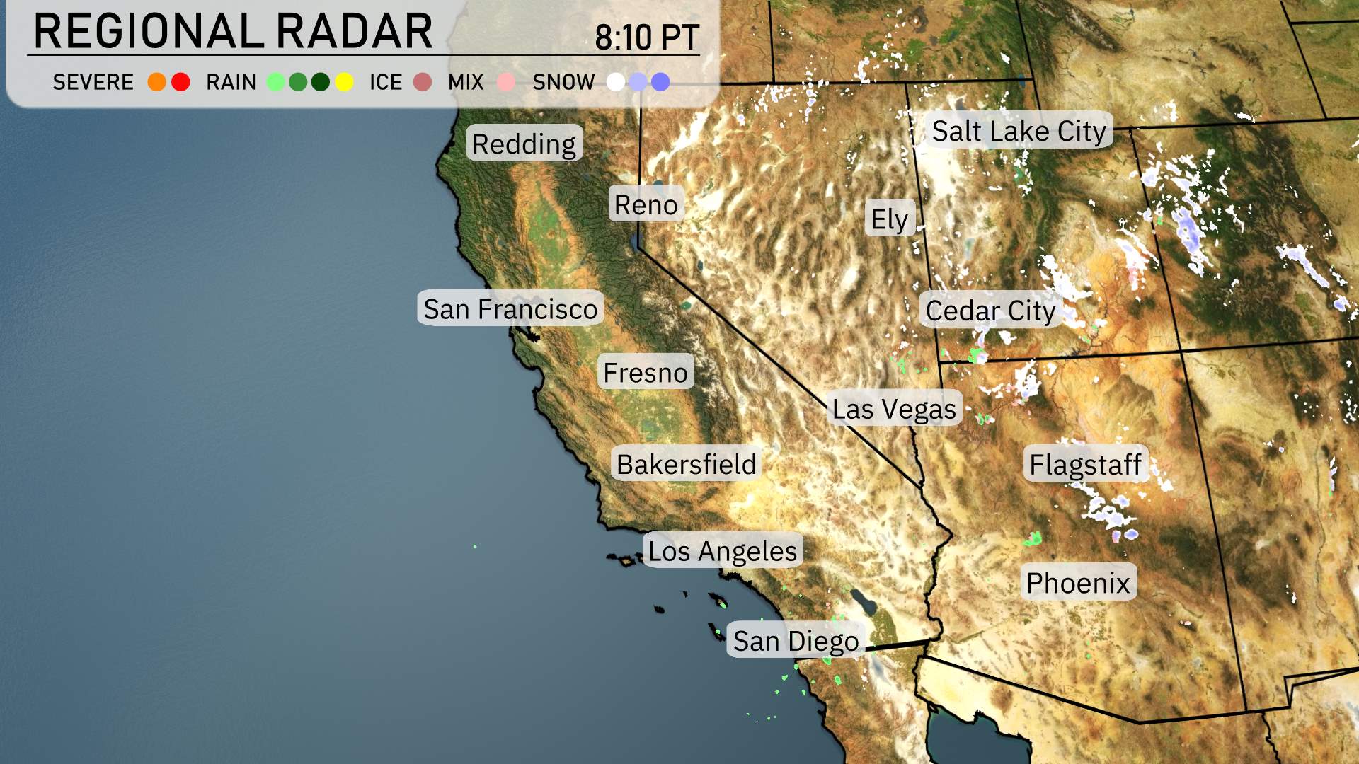
The Southwest region is experiencing a mix of weather conditions today. On the radar, rain is sweeping inland from the Pacific Ocean, bringing much-needed moisture to the California coastline. Redding and San Francisco are receiving steady rainfall, providing some respite amidst dryer conditions.
Central California, including Fresno and Bakersfield, is witnessing rain showers that are moving inland, while the Sierra Nevada mountains are blanketed with snow, creating a picturesque winter scene. Reno is experiencing mixed precipitation, with both rain and light snow, indicating colder conditions in the area.
Farther south, Los Angeles is having a more mild weather pattern with just light drizzle, while San Diego appears mostly clear and dry. Ascending eastward, Flagstaff is experiencing light snowfall, adding some chill to the air.
Las Vegas stays dry, and Phoenix enjoys clear conditions.
For this evening in Salt Lake City, expect partly cloudy conditions transitioning to mostly clear skies by 11 PM. Temperatures decrease from 46 degrees at 9 PM to 41 degrees, dropping farther to 37 degrees by 1 AM. Winds will be gentle, beginning from the northwest at 8 miles per hour, then shifting to 4 miles per hour, before calming to easterly winds at 4 miles per hour. A crisp and cool evening ahead!
Flagstaff plunges to 25 degrees tonight. Over in Cedar City, Utah, expect a low of 25 degrees as well. Las Vegas stays relatively warmer at 50 degrees, and Phoenix is comfortable at 54 degrees. In California, San Francisco will see a low of 50 degrees, while Fresno drops to 46. Bakersfield will cool to 48 degrees. A chilly night across the Southwest, so bundle up!
In the desert regions, Las Vegas is set to reach a high of 70 degrees, contributing to the ongoing warm trend. Phoenix will also see conditions heating up with a high of 73 degrees, which is slightly above average for early April.
Farther west, in California, Bakersfield and Fresno will both hit a warm 72 degrees. Los Angeles will experience more mild weather with a high of 68 degrees, while coastal San Diego is expected to reach 66 degrees.
Overall, the general warm air mass is dominating the Southwest, while areas further north, like Cedar City, will stay quite chilly at just 46 degrees.
Expect a varied weather pattern across the Southwest tomorrow. The desert areas remain dry and sunny, ideal for outdoor activities. However, California’s coastlines and interior regions, including the San Francisco Bay Area, will see waves of rain throughout Thursday, potentially leading to slick conditions. The Sierra Nevada might experience light snowfall in higher elevations, making travel tricky over mountain passes. Stay alert, as showers extend to Nevada and into parts of Arizona, although the core deserts stay clear. Keep an eye out for updates, especially if you’re traveling in these varied conditions.
Salt Lake City’s UV index on Thursday is moderate at 5, with potential sun exposure leading to burns in about 27 minutes. By Friday, the index climbs to 6, so ensure you’re ready with sunscreen and hats as burn time reduces to just 23 minutes.
For the 7-day forecast in Salt Lake City:
Thursday: Mostly clear with a high of 45 degrees and a low of 29.
Friday: Partly cloudy skies, warming up slightly to a high of 49 degrees, with nighttime lows around 30.
Saturday: Clear and sunny conditions, daytime temperatures will reach 53 degrees, dropping to 33 overnight.
Sunday: Mostly clear skies with a high of 59 degrees and lows near 39.
Monday: Cloudy skies early, clearing late. Expect a high of 66 degrees and a low of 45.
Tuesday: Partly cloudy with temperatures peaking at 65 degrees during the day and cooling to 47 at night.
Wednesday: Continuing partly cloudy with a high of 67 degrees and an evening low of 45.
Hope that helps you plan your week! Stay safe!