Swinging Temperatures: From Chilly Showers to Sunny Highs in the Southwest
By
Amy Freeze
From refreshing showers in Southern California to scorching sun in Phoenix, the Southwest is experiencing a cocktail of climates. See how these conditions can affect your plans and what you can expect in the coming days.
This week, the Southwest offers a vibrant display of weather patterns. Check out our blog post to find out what’s in store from cold showers to warm sunny skies with tips from Meteorologist Amy Freeze.
Prepare for an exciting range of temperatures and conditions across the Southwest. From light rain showers affecting Southern California’s coast, heavy rain in central valleys, and unexpected snow in Sierra Nevada, to dry and calm conditions in Phoenix. Each day brings something new. Read our detailed forecast now at https://amyfreeze.ai/ to ensure you’re fully prepared for the week ahead!
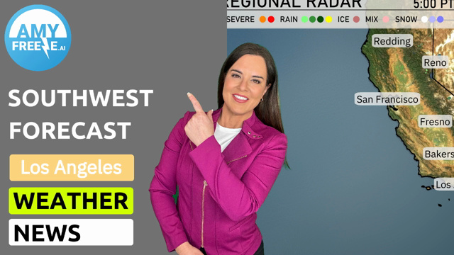
A weather system is currently addressing the Southwest region with a mix of conditions. In Southern California, light rain showers are making their way along the coast from Los Angeles down to San Diego, bringing some welcome hydration to the area. Meanwhile, heading northward, more substantial rain is observed sweeping into the central valleys, especially around Fresno and Bakersfield.
In Northern California, Redding is experiencing more persistent rain from the Pacific. The Sierra Nevada is receiving snowfall, affecting locations like Reno and Ely, where snow showers are contributing to higher elevation accumulations. As we move eastward, Cedar City is encountering some light snow while Flagstaff is experiencing chilly conditions with chances of snow flurries.
On the other hand, Phoenix and Las Vegas remain largely dry, offering respite from any precipitation, with calm conditions prevailing over this region. This varied weather pattern marks an engaging day in the Southwest area, with plenty of activities for weather enthusiasts!
For the evening in Los Angeles, anticipate a cloudy pattern with temperatures gradually decreasing from 59 degrees at 8 PM to 56 degrees by midnight. Winds will start from the south-southwest at 8 miles per hour at 8 PM, then ease to 5 miles per hour by 10 PM, becoming calm as midnight approaches.
Now for the low temperatures tonight across the Southwest. Ely will experience a significant drop, with temperatures plummeting to a chilly 24 degrees. Las Vegas will cool down to 53, while Cedar City checks in at 30 degrees. Flagstaff is forecasted to see a low of 33. This evening, Los Angeles will have a mild night at 50 degrees, with San Diego just a bit warmer at 54. Meanwhile, temperatures in Bakersfield will dip to 48 degrees, and Fresno will settle at 44. Expect cooler conditions throughout the region as we move into the night.
High temperatures for the Southwest region tomorrow are expected to be quite warm, especially in the desert areas.
– **Phoenix** leads the charge with a notable high of **84 degrees**, significantly above average for this time of year.
– **Las Vegas** will also be feeling the warmth, reaching **77 degrees**.
– Over in **Bakersfield**, anticipate a high of **71 degrees**, which is slightly above normal.
– Meanwhile, **Fresno** reports highs around **64 degrees**, aligning closely with seasonal averages.
– **Los Angeles** can expect a comfortable **64 degrees**.
– Further north, **San Francisco** will be a bit cooler at **58 degrees**, while **Ely** will see a cooler high of **54 degrees**.
Overall, a ridge of high pressure is contributing to these warmer temperatures, particularly in the central and southern parts of the region.
“On the Southwest futurecast, an active weather pattern develops. Northern California should prepare for rounds of valley rain, continuing into early Monday, with possible heavy downpours. For southern California, expect intermittent showers in the San Bernardino Valley, causing tricky driving conditions over mountain passes. A low-pressure system brings more mild and breezy conditions to the desert southwest, with cooler temperatures following the passage. Keep an eye on the forecast for updates on rainfall intensity and weather impacts.”
For those expecting to find some fun in the sun, pay attention to the UV rating for Los Angeles. The index is 6 on Sunday, making the sun moderately strong, with a burn time of about 23 minutes. On Monday, the UV index decreases to 5, with a burn time of 27 minutes. Remember to protect your skin with sunscreen and wear a hat when outdoors!
For the 7-day forecast in Los Angeles:
Sunday: Expect light showers with a high of 61 degrees and a low of 56 degrees.
Monday: It clears up a bit with partly cloudy skies, temperatures warming slightly to 62 degrees, and a low of 50.
Tuesday: Clouds early, but they clear later, with a high reaching 64 degrees and a low of 48.
Wednesday: Mostly clear skies and a bit cooler, with a high around 62 degrees and a low of 49.
Thursday: Partly cloudy conditions with temperatures peaking at 60 degrees and dropping to 48 at night.
Friday: Mostly clear, warming up with a daytime high of 62 degrees and a low near 50.
Saturday: Enjoy clear skies and a warm-up, with temperatures reaching 66 degrees and a low of 52.
Stay safe and enjoy the week ahead!