Chasing Clouds: Amy Freeze’s Detailed Report on the Southwest’s Weather Shifts
By
Amy Freeze
Explore a comprehensive review of the Southwest’s complex weather through the insights of Meteorologist Amy Freeze. From snowy mountain passes to serene sunny days, understand what’s happening right outside your door.
Dive into this detailed blog post exploring the diverse weather conditions sweeping across the Southwest. Meteorologist Amy Freeze breaks down everything from light showers in LA to snowfall in Reno.
Welcome to a comprehensive exploration of the Southwest’s varying climate conditions with Meteorologist Amy Freeze. As we journey from city to mountain, we uncover how light rains, sporadic snowfalls, and clear sunny days shape the lives and landscapes from San Francisco to Phoenix. Complete with temperature rundowns and predictions, this content ensures you’re fully prepared for the week ahead. Check out the full story here: https://amyfreeze.ai/
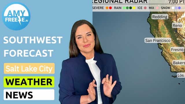
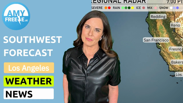
The Southwest region is experiencing quite a diverse mix of weather today. A line of showers is advancing through central California, providing much-needed rainfall from Redding down through Fresno and Bakersfield. This precipitation offers relief for these areas, while higher elevations around Reno are seeing snowfall, which might impact travel.
The coastline from San Francisco to Los Angeles is seeing light-to-moderate rain, with some spots experiencing brief, heavier downpours. Las Vegas is escaping the rain, staying dry, while farther east, Flagstaff is under clouds with a chance of light snow, which adds a wintry feel to the day.
Cedar City faces a light mix of rain and snow, contributing to the varied weather pattern across the Southwest.
Moving to the northeastern stretches, Salt Lake City has a break from significant precipitation.
For this evening in Los Angeles, temperatures will start at 59 degrees at 8 PM and gradually decrease to 55 degrees by midnight. The sky will be mostly cloudy through the late evening, transitioning to partly cloudy skies towards midnight. Expect a southwest wind at 8 miles per hour at 8 PM, calming to 4 miles per hour from the west-southwest by midnight
Tonight in the Southwest, we’re seeing some chilly temperatures as a cold front settles in. Ely will drop to a brisk 22 degrees, while Flagstaff braces for a frigid 20. Cedar City isn’t far behind at 26 degrees. Las Vegas will see a low of 50, and Bakersfield is expected to cool to 45. In contrast, Phoenix will remain more mild at 52 degrees, while San Diego ends the night at a comfortable 51.
Here’s the regional high temperature rundown for the Southwest this Tuesday:
Las Vegas will see a warm day, with temperatures reaching 66 degrees, slightly above average for this time of year. In Phoenix, expect a high of 74 degrees, which is also above seasonal norms due to the influence of a high-pressure system settling in.
Moving to the coastal areas, San Diego will experience a high of 60 degrees, a more mild day compared to the inland regions. Los Angeles will warm up to 66 degrees, suggesting a comfortable day in the city.
Farther north, Bakersfield will see a high of 61 degrees, while Fresno checks in at 55 degrees, somewhat cooler than average. San Francisco will remain cool at 56 degrees, under the influence of lingering marine layer effects.
In Ely, temperatures will struggle to reach 40 degrees.
Across the Southwest tomorrow, anticipate a shift in weather patterns with a cold front moving through the region. Northern California is set to experience rounds of valley rain, particularly impacting the Sierras with snow accumulation. This could lead to hazardous travel conditions over the mountain passes. Farther south, from the San Francisco Bay Area to Los Angeles, expect scattered showers that might contribute to tricky travel, especially during peak commute times. In the desert regions, a more stable environment will prevail with generally dry conditions and temperatures slightly below normal due to the frontal passage.
The UV index in Los Angeles starts at a moderate 5 on Monday, with a potential burn time of 27 minutes if skies clear. However, watch out for showers that might reduce exposure. By Tuesday, the sun intensifies slightly, raising the UV index to a high 7, with a quicker burn time of around 20 minutes. Be sure to wear your sunscreen and hats!
Tuesday: Enjoy a partly cloudy day in Los Angeles with a high of 63 degrees and a low of 47.
Wednesday: The sunshine continues with mostly clear skies, reaching a high of 64 degrees and cooling to 49 overnight.
Thursday: Expect mostly clear conditions with a high temp of 60 degrees and a nighttime low of 47.
Friday: The day will be mostly clear, with temperatures peaking at 62 degrees and dropping to 49 overnight.
Saturday: Look forward to clear skies and temperatures around 65 degrees, with an evening low of 52.
Sunday: Mostly clear conditions with a warmer high of 70 degrees and a mild low of 54.
Monday: Sunny and partly cloudy, reaching 63 degrees during the day and dipping to 50 at night.
Hope that helps! Enjoy the beautiful week ahead in Los Angeles!