Temperature Twists in the Southwest: Salt Lake City’s Evening Forecast
By
Amy Freeze
Explore the flux of high heat across major Southwest cities like Phoenix and Las Vegas, with a special focus on Salt Lake City's evening outlook.
Catch up on tonight’s weather forecast for Salt Lake City and the broader Southwest, as delivered by Amy Freeze. Expect updates on temperatures, UV indices, and precipitation across various cities.
Join Meteorologist Amy Freeze as she delivers the latest updates on weather across the Southwest. From the blazing heats in Las Vegas to cooler evenings in Salt Lake City, keep ahead of unexpected weather changes with your reliable southwest forecast.
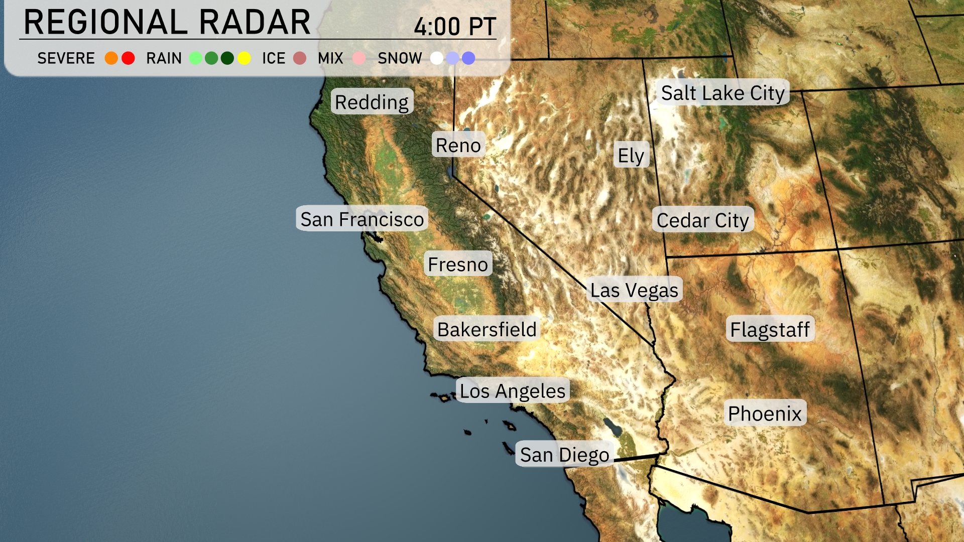
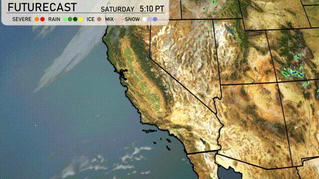
Over the Southwest, heat grips the region. Redding and areas north experience widespread precipitation into Reno. The Sierra Nevada is seeing Spring snow, impacting travel across mountain passes. While the rain brings relief to Fresno and Bakersfield, the rain in California is short lived. Coastal areas such as San Francisco and Southern California, including Los Angeles, remain mostly clear.
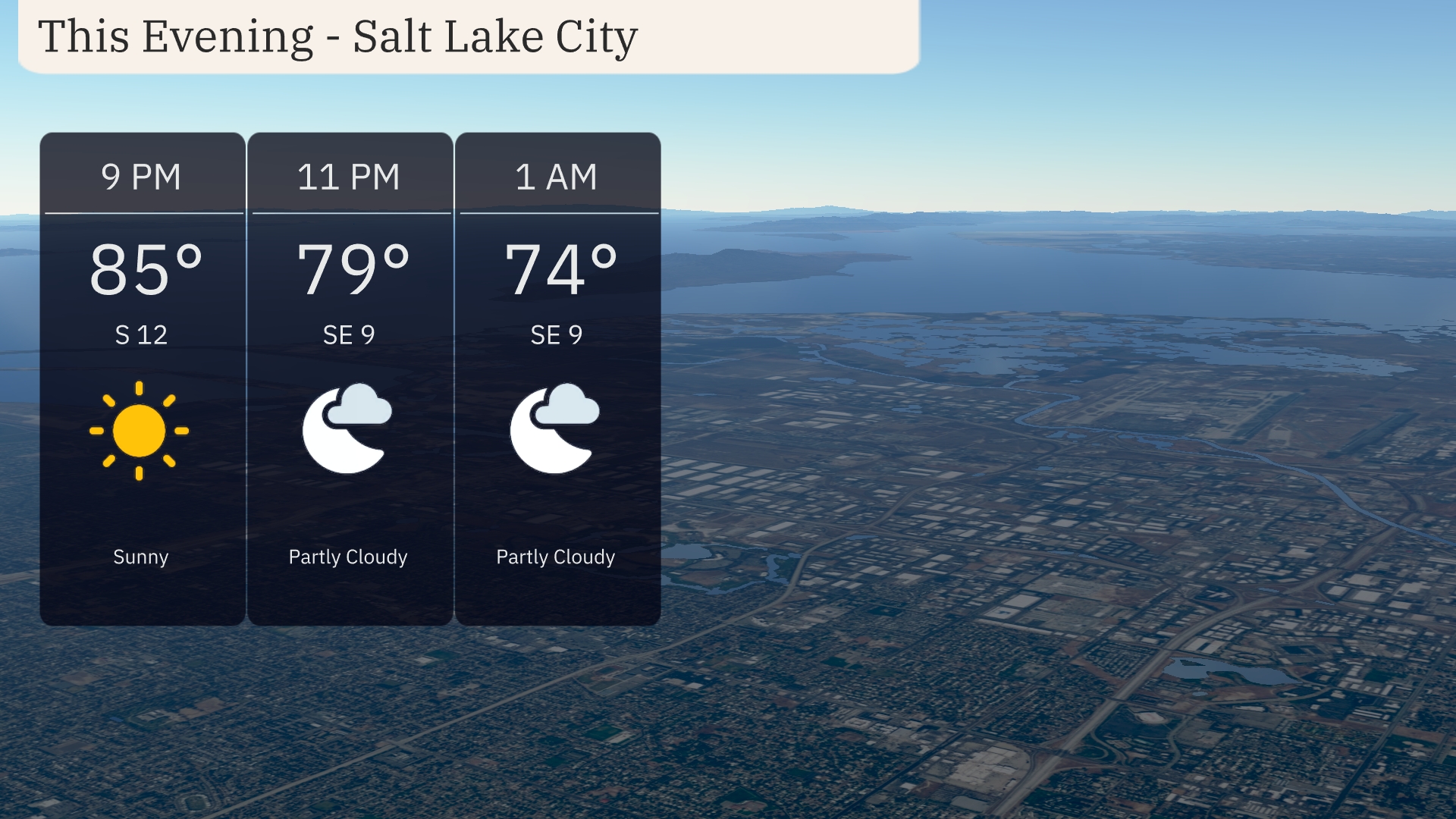
For this evening in Salt Lake City, temperatures remain warm, starting at 85 degrees at 9 PM and gradually cooling to 74 degrees by 1 AM. A gentle southeast wind at 12 miles per hour will accompany clear skies early on. Cloud cover increases as the night progresses with a partly cloudy sky by 11 PM.
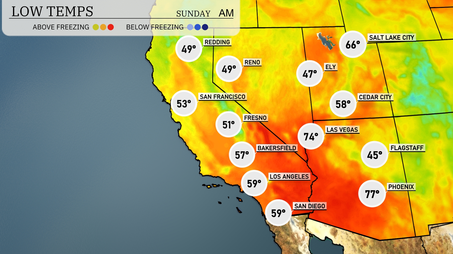
Tonight in the Southwest, Las Vegas dips to 58. In southern California, Los Angeles and San Diego will remain milder at 59 degrees, while Bakersfield will see a low of 57. Fresno cools down to 51 degrees, and San Francisco is forecasted at 53. Expect the coolest readings in northern cities, with Redding and Reno both hitting 49 degrees.
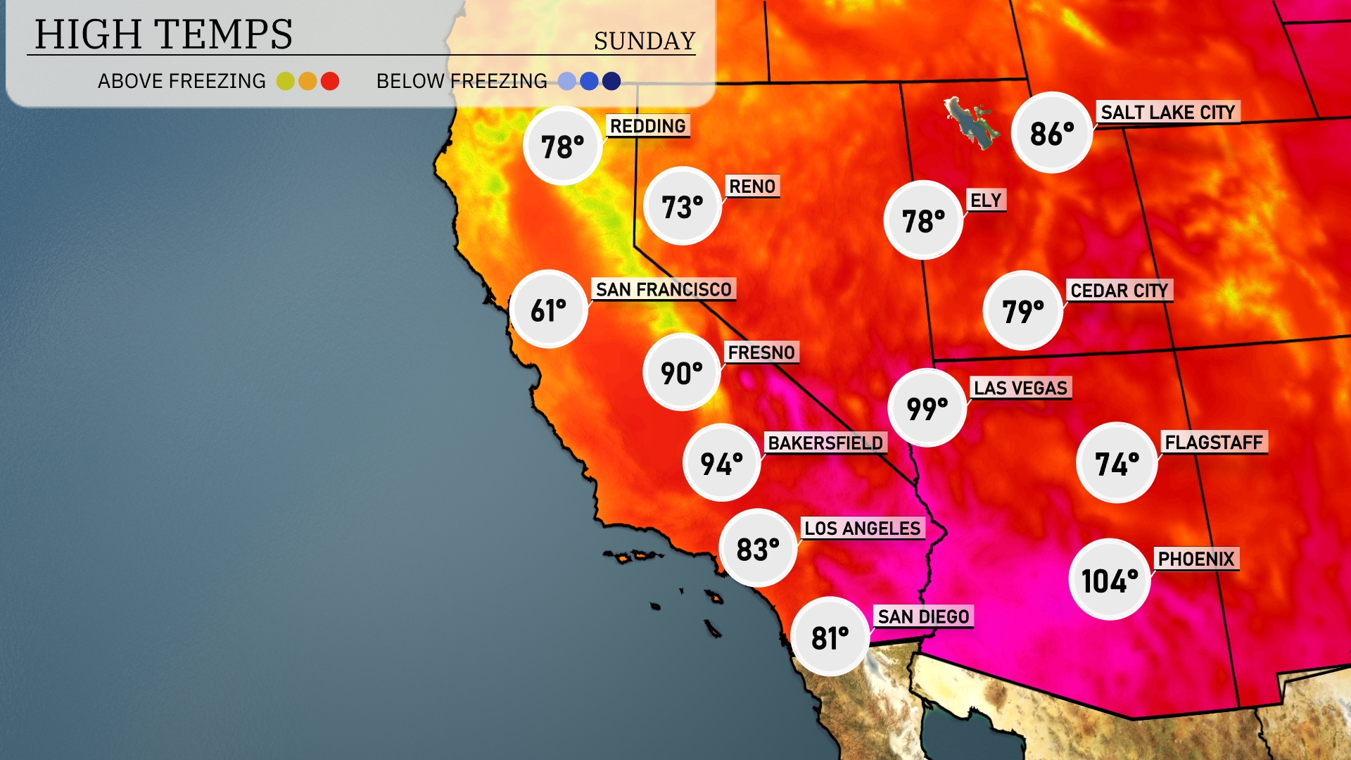
Tomorrow, the Southwest will experience above-average temperatures as a high-pressure system continues to dominate the region. Phoenix is set for a scorching high of 104 degrees, while Las Vegas will see a warm 99 degrees. Bakersfield should reach 94 degrees, with Fresno not far behind at 90 degrees. Los Angeles will enjoy a comfortable 83 degrees, and coastal areas like San Diego warm up to 81 degrees.
A cold front will advance through the Southwestern U.S. tomorrow, bringing increased cloudiness and a chance of scattered showers, particularly in Arizona and New Mexico. Be prepared for occasional thunderstorms that may produce gusty winds, especially during the afternoon. Temperatures will dip slightly behind the front, with highs dropping to the mid-70s in the valleys, while cooler air settles over higher elevations. No severe weather is expected, but localized heavy rainfall could lead to brief flooding concerns in low-lying areas.
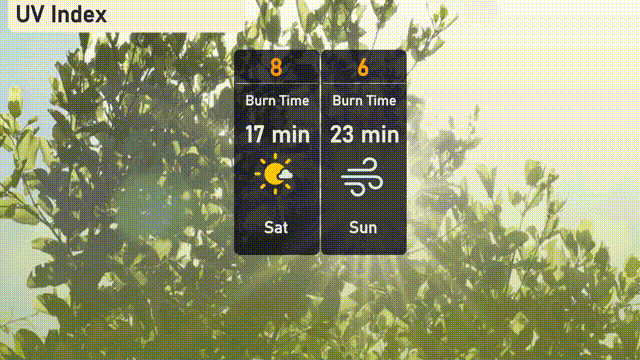
The UV index in Salt Lake City will be high on Saturday with a value of 8, indicating a burn time of about 17 minutes in direct sunlight. On Sunday, the UV index is expected to moderate to 6, with a burn time of 23 minutes. Consider wearing sunscreen, sunglasses, and a hat if you’re planning outdoor activities.
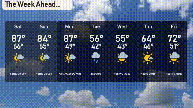
For the 7-day forecast in Salt Lake City:
Saturday: Enjoy partly cloudy skies with a warm high of 87 degrees and a low of 66.
Sunday: Partly cloudy again, cooling down slightly with a high of 84 degrees and a low of 65.
Monday: Cloudy and windy conditions as temperatures reach a high of 87 degrees and a low of 49.
Tuesday: Showers in the forecast, with much cooler temps hitting a high of 56 degrees and a low of 42.
Wednesday: Mostly cloudy skies with temperatures peaking at 55 degrees and dropping to 43 at night.
Thursday: Clouds are clearer, bringing mostly sunny skies and a high of 64 degrees, with lows around 46.
Friday: Mostly cloudy weather to wrap up the week, temperatures rising to a high of 72 degrees and a low of 51.