Sunny Days and Sudden Showers: Navigating This Week’s Dynamic Southwest Weather
By
Amy Freeze
Explore the latest weather dynamics across Salt Lake City and the broader Southwest with updates on temperature trends, precipitation patterns, and what to expect in the coming week.
Dive into our comprehensive Southwest weather guide with Amy Freeze as she outlines the forecast for Salt Lake City and beyond, including sunny days with intermittent showers and notable temperature changes.
Meteorologist Amy Freeze brings you the latest weather updates for Salt Lake City and the Southwest region. This detailed post covers everything from San Francisco’s and Fresno’s rain showers to the cool temperatures rolling into Las Vegas and Phoenix’s sizzling warmth. Also, get a sneak peek of what to expect weather-wise in the coming days with a specific focus on potential rain showers and elevated temperatures. Stay informed and prepared with safety tips and precautions for varying weather conditions. Concluding with a seven-day forecast, this blog ensures you’re well-prepared for the week ahead in Salt Lake City.
The latest radar analysis for the Southwest region indicates a mix of weather conditions. San Francisco and Fresno are experiencing rain showers moving through the area, providing some respite from dry conditions. Farther north, Redding is also seeing rain, adding to the precipitation pattern across central California. Flagstaff, Arizona, is also seeing some light snow showers, aligning with the cooler conditions expected in higher elevations. In Southern California, Los Angeles is experiencing mild conditions with no significant precipitation. However, Las Vegas remains dry with clear skies, indicating a relatively calm weather scenario for now.
For this evening in Salt Lake City, anticipate temperatures beginning at 55 degrees at 8 PM, dipping to 51 degrees by 10 PM, and reaching 48 degrees by midnight. Winds shift from northwest to southeast, then east-southeast, ranging between 5 and 6 miles per hour. The sky transitions from partly cloudy to mostly clear, settling back to partly cloudy later into the night.
Tonight in the Southwest, expect a notable drop in temperatures as a cold air mass settles in. Ely will experience a chilly low of 35 degrees. Las Vegas stays milder at 59. Over in Flagstaff, be ready for a brisk night at 36 degrees. Cedar City is forecasted to dip to 40 degrees. Los Angeles will see cooler conditions too, with a low of 53. Further south, San Diego rounds out the night at a more mild 54 degrees. Keep those jackets handy!
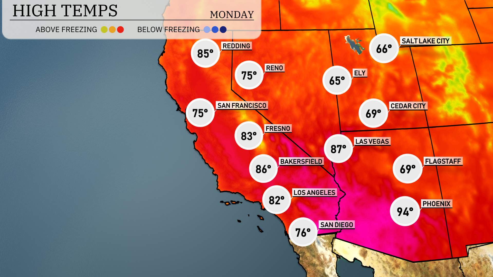
High temperatures for the Southwest region are shaping up to be quite warm tomorrow, with many cities experiencing above-average readings. In Phoenix, expect a sizzling high of 94 degrees, significantly higher than typical for this time of year. Las Vegas will also feel the heat with a high reaching 87 degrees.
Farther along the California coast, Los Angeles will warm up to 82 degrees, while San Diego enjoys a pleasant 76 degrees. Inland, Bakersfield is forecasted to hit 86 degrees, and Fresno will reach 83 degrees.
To the north, Ely, Nevada, will see a cooler high of 65 degrees, while Reno tops out at 75 degrees. Overall, the warm weather is influenced by high pressure settling in over the region, leading to these elevated temperatures.
“On the futurecast for the Southwest, we’re expecting a dry and sunny pattern through much of the desert regions. However, keep an eye on Northern California! A series of rain showers are anticipated as a frontal system moves through, bringing potential slick conditions on roadways. Over Southern California, including the San Bernardino Valley, expect continued rounds of heavier rain on Monday into Tuesday, which may cause localized flooding. Increases in precipitation could challenge travel conditions, especially through elevated terrains.”
The UV index in Salt Lake City is moderate at 5 on both Sunday and Monday, with a burn time of approximately 27 minutes in direct sunlight. Take precautions like wearing sunscreen and seeking shade during midday to protect your skin.
For the 7-day forecast in Salt Lake City:
Sunday: Partly cloudy with a high of 57 degrees and a low of 42.
Monday: Clear skies, enjoying a high of 64 degrees and a low of 43.
Tuesday: Another clear day ahead, reaching up to 68 degrees with a low of 45.
Wednesday: Partly cloudy, warming up to 73 degrees during the day and cooling to 52 degrees at night.
Thursday: Mostly cloudy, expect a high of 72 degrees and a nighttime low of 44.
Friday: Rain and snow showers develop late, with a high of 49 degrees and a low of 37.
Saturday: Partly cloudy conditions continue, with temperatures peaking at 52 degrees and dipping to 36 degrees.