From Heatwaves to Cool Nights: A Week of Western Weather Wonders
By
Amy Freeze
Explore a week of dramatic weather changes across the Southwest, from scorching days to cool nights, and how these conditions affect local life.
This week, the Southwest oscillates between extreme temperatures. Discover how Salt Lake City and its neighbors fare with daily updates!
Welcome to your weekly weather roundup for the Southwest! This week, we observed a spectrum of weather conditions across the region. Salt Lake City enjoyed partly cloudy skies with pleasant evening temperatures, while Phoenix hit the boiling point at 106 degrees. Discover more about the unexpected storm in Redding and the mild temperate days in San Diego in our detailed analysis. Keep up-to-date with our forecasts to ensure your plans remain weather-proof!
In the Southwest region, radar shows active weather primarily in northern California. Redding is experiencing intense storms with severe weather alerts in place. Reno has rain showers extending southward. Nevada mainly sees clear skies, except for some light cloud cover around Ely.
This evening in Salt Lake City, look for partly cloudy skies with temperatures starting at 74 degrees at 9 PM, cooling to 61 degrees by 1 AM. Northwest winds will be present, blowing at 15 mph at 9 PM, then picking up to 21 mph by 11 PM before decreasing to 17 mph by 1 AM. A calm and pleasant evening is expected as cloud cover continues into the night.
Tonight, Las Vegas will experience a low of 69 degrees, while temperatures in Flagstaff will drop to a chilly 44. Phoenix remains warmer at 77 degrees, but areas like Ely will see a significant dip to 34. Expect cooler conditions across the region as nighttime temperatures settle in.
Tomorrow, Phoenix will be sizzling at a scorching 100 degrees, well above average for this time of year. Las Vegas is not far behind, expecting a high of 93 degrees, maintaining warm conditions. In contrast, Los Angeles will see a milder high of 73 degrees, while San Diego will reach 74 degrees. Bakersfield and Fresno will both hit 88 degrees, showcasing a slight warm trend across the central parts of California. San Francisco remains cooler at 69 degrees, a notable drop compared to the more southern areas.
For tomorrow in the Southwest, expect a warm and sunny day across the region with temperatures climbing into the mid-90s. However, a trough will bring increased cloudiness and the chance of isolated thunderstorms, particularly in eastern Arizona and western New Mexico by late afternoon. While severe storms are unlikely, brief heavy downpours and gusty winds could occur. Keep an eye on the sky if you’re in these areas.
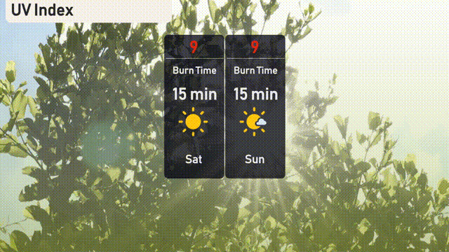
The UV index in Salt Lake City is set to reach a very high level of 9 on both Saturday and Sunday, with a burn time of just 15 minutes in direct sunlight.
Saturday: Showers pop up late with temperatures reaching 76 degrees for a high and a low of 47 degrees.
Sunday: Mostly clear skies with the temperature climbing to 67 degrees during the day and cooling to 48 degrees overnight.
Monday: Partly cloudy with highs around 78 degrees and the low dipping to 56 degrees.
Tuesday: Another partly cloudy day with highs peaking at 80 degrees and a low near 56 degrees.
Wednesday: Clear skies make for a beautiful day, warming up to 85 degrees with a nighttime low of 60 degrees.
Thursday: Temperatures rise further under partly cloudy skies, reaching a warm 93 degrees with a low of 66 degrees.
Friday: Mostly clear conditions maintain the warmth with a high of 93 degrees and a low of 64 degrees.