Weather Command: Navigating Thunderstorms and Sunny Spells Across the U.S.
By
Amy Freeze
Explore the impact of an active cold front moving across the U.S., from thunderstorms on the East Coast to sunny dias in the central states and what it means for your area.
Today’s U.S. weather offers a mix from thunderstorms along the East Coast to clear skies in the central regions. Stay prepared with the latest updates from Weather Command.
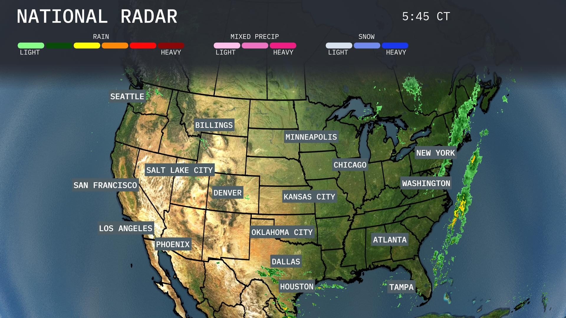
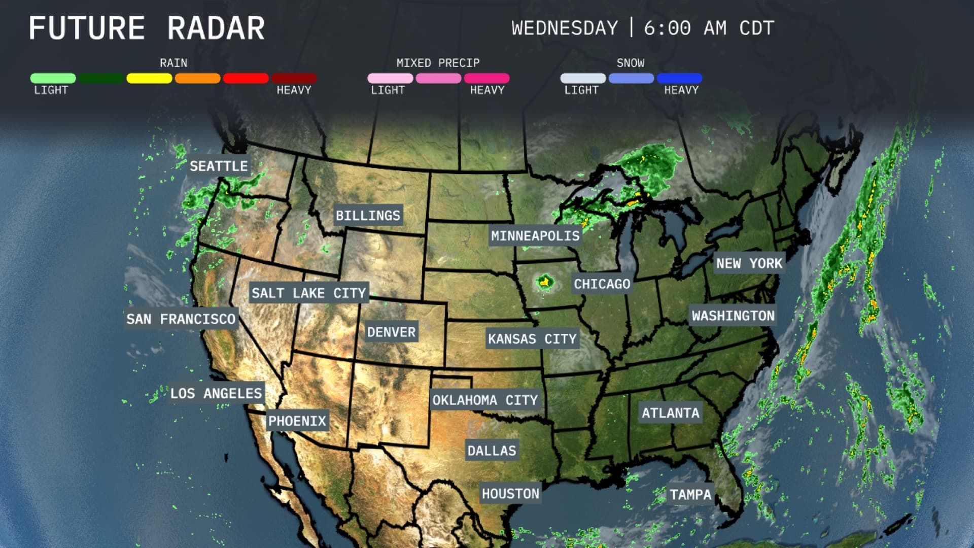
As we monitor the active cold front sweeping through the Midwest and triggering thunderstorms along the East Coast, it’s crucial to stay updated on weather conditions. The clear skies from Kansas City to Houston contrast with the wet weather impacting travel from Washington, D.C. to New York City. Additionally, the Rocky Mountains and the Pacific Coast enjoy calm weather today. Keep an eye on the forecasts for changes, as we anticipate warm temperatures bringing a comfortable day to the Southeast tomorrow. Prepare for potential localized flooding in storm-prone areas. With continuous shifts in the weather, staying informed ensures your safety and preparedness.
There’s a significant line of thunderstorms extending along the East Coast, affecting areas from Washington, D.C. to New York City, which could impact travel with heavy rain. Meanwhile, in the central U.S., clear skies prevail from Kansas City down through Dallas and Houston. The Rocky Mountain region around Denver and cities like Billings enjoy dry conditions today. The Pacific Coast, including Seattle and San Francisco, remains calm with no major precipitation, offering a pleasant day ahead.
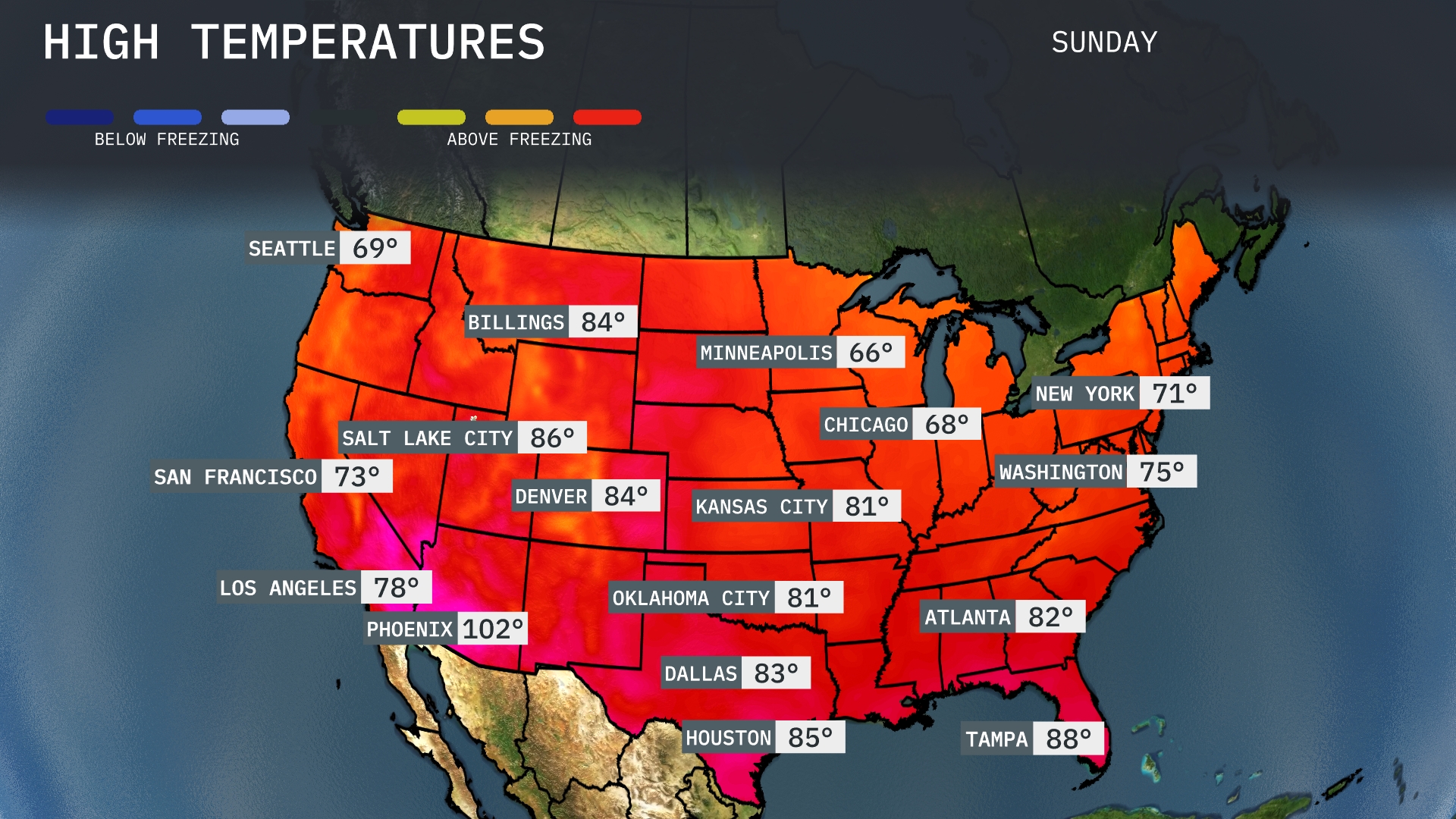
Today, we see a warm-up across much of the country, with Phoenix leading the way at a scorching 102 degrees, making it the hottest city of the day. Heading east, Dallas reaches a comfortable 83 degrees, while Houston is slightly warmer at 85. In the Southeast, Tampa sizzles at 88 degrees, contrasted by Atlanta’s more moderate high of 82. Up north, Chicago and Minneapolis remain on the cooler side at 68 and 66 degrees, respectively, showcasing the continuous temperature gradient across the regions.
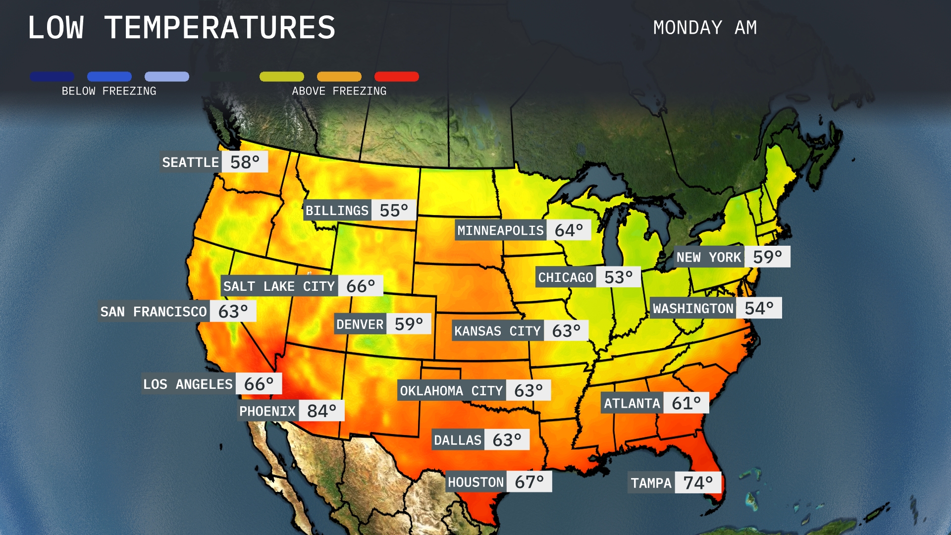
Now for the low temperatures tomorrow morning across the U.S. The northern plains will experience a chilly start, with Minneapolis at 64 degrees and Chicago a bit cooler at 53. Moving down to the Midwest, Kansas City and Oklahoma City will settle at 63 degrees each. In the Southeast, Atlanta is expected to start at 61 degrees, while Washington, D.C. will come in slightly lower at 54 degrees, keeping things mild. Meanwhile, the Southwest remains toasty with Phoenix reaching a warm 84 degrees.
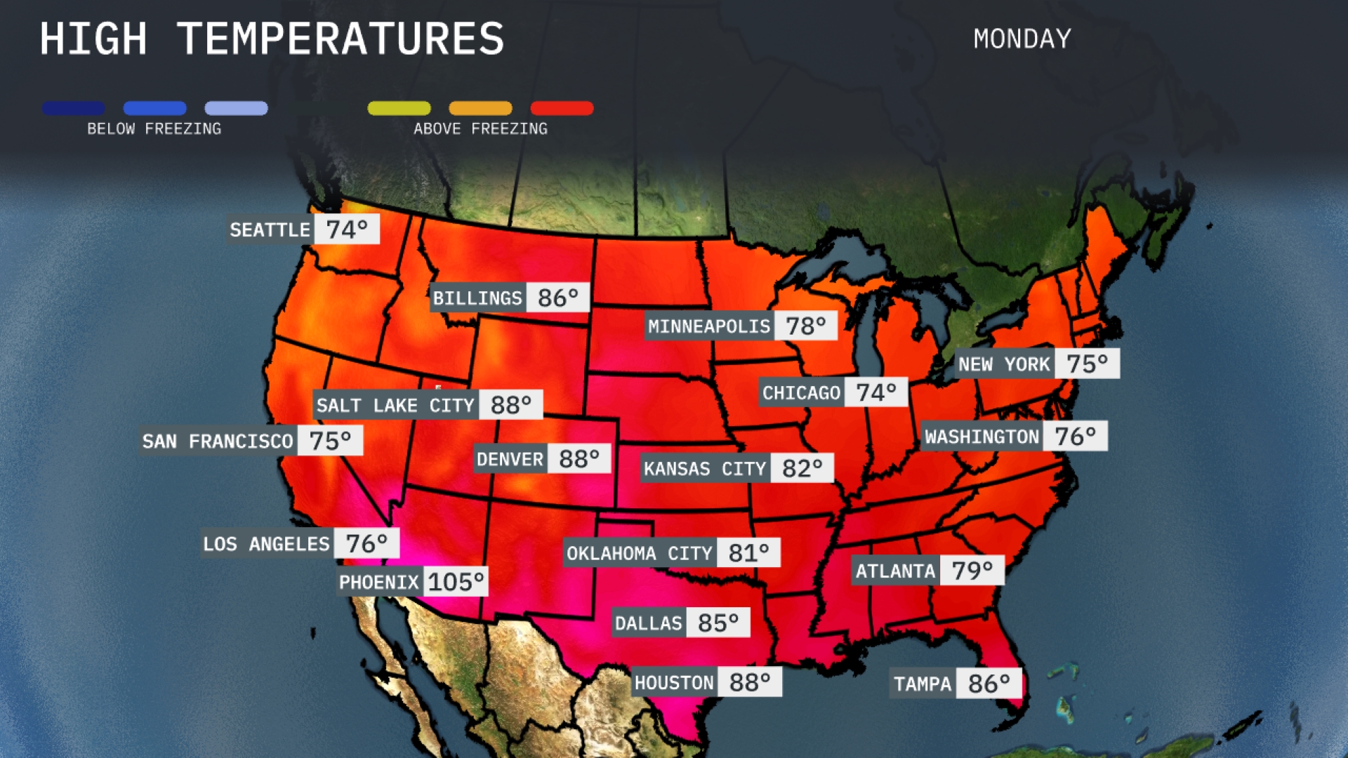
Tomorrow, the region is gearing up for notably warm temperatures, with much of the area trending above average. In Dallas, anticipate a high of 85 degrees, while Houston will reach 88 degrees, both indicating a pleasant summer stretch. Moving east, Atlanta can expect a high of 79 degrees, and further south, Tampa is forecasted to hit 86 degrees, contributing to the overall warm pattern across the Southeast. The high pressure system settling in is helping to push these temperatures upward, making for a comfortable day across the region.
A robust frontal system is moving through the Midwest, bringing heavy rain and potential thunderstorms from Minneapolis to Kansas City over the next 48 hours, accompanied by cooler air. The Southeast, extending from Atlanta to Washington, D.C., should prepare for scattered thunderstorms and possible localized flooding as this system advances. Meanwhile, in the Pacific Northwest, Seattle experiences continuous rainfall, contrasting with the sunny, dry conditions prevalent in Southern California. Keep an eye on weather developments, especially in storm-prone areas to ensure safety and preparedness.