April Showers & Sun: A Coast-to-Coast U.S. Weather Analysis by Amy Freeze
By
Amy Freeze
From snowy plains to sunny shores, Amy Freeze explores the diverse weather patterns sweeping the U.S. this April. Stay informed from city to city with this comprehensive weather roundup.
April brings a mix of meteorological surprises across America. Explore everything from rain-soaked cities to sunlit streets in our latest blog post by Amy Freeze!
This April, the U.S. sees a dramatic mix of weather phenomena. The Pacific Northwest is dominated by clear skies and mild temperatures, while the Northern Plains battle through heavy snowfalls. The Midwest stays chilly, with some areas awakening to frosty mornings. The East and South enjoy clearer and warmer conditions, with Florida bracing for overnight rains. Stay updated on this diverse climatic journey across the country with insights from meteorologist Amy Freeze.
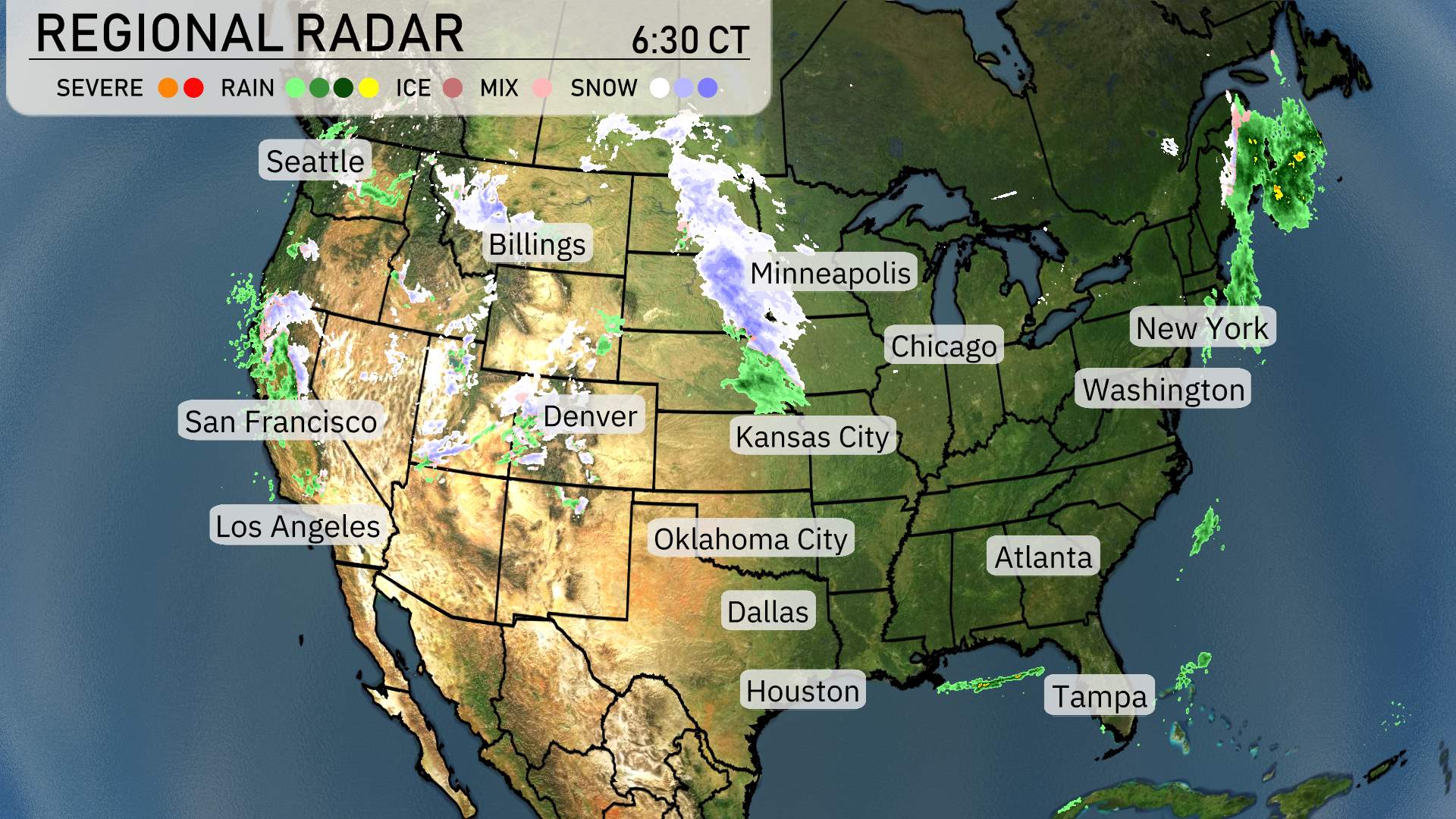
On this national radar, we can see a variety of weather patterns sweeping across the country today. Starting in the Pacific Northwest, Seattle appears mostly wet with extensive rain coverage, while higher elevations around the Cascade Range are experiencing snow, impacting areas like Spokane. Moving eastward, Denver is under a mix of precipitation, indicating potential snow and rain as it transitions over.
In the Northern Plains, a strong band of snow stretches from Billings through to Minneapolis, suggesting heavy snow is impacting these areas. This region is likely experiencing travel disruptions and possible winter weather advisories.
The central part of the country, stretching from the Rockies through Kansas City, enjoys relatively calm conditions with no significant precipitation.
Looking further east, the Northeast, particularly upstate New York and further into New England, is encountering more snow, which could lead to challenging travel conditions in places like Buffalo and Albany. Down along the Eastern Seaboard, Washington D.C. and New York are currently spared from significant rainfall, maintaining clearer conditions for now.
In the Southeast, Atlanta is under clear skies, offering a pleasant break from any precipitation. Tampa enjoys sunshine, while more rain bands are moving into the Florida Peninsula overnight.
Across the Southwest and into California, conditions are dry. San Francisco, Los Angeles, and across the Nevada desert enjoy relative calm weather for now.
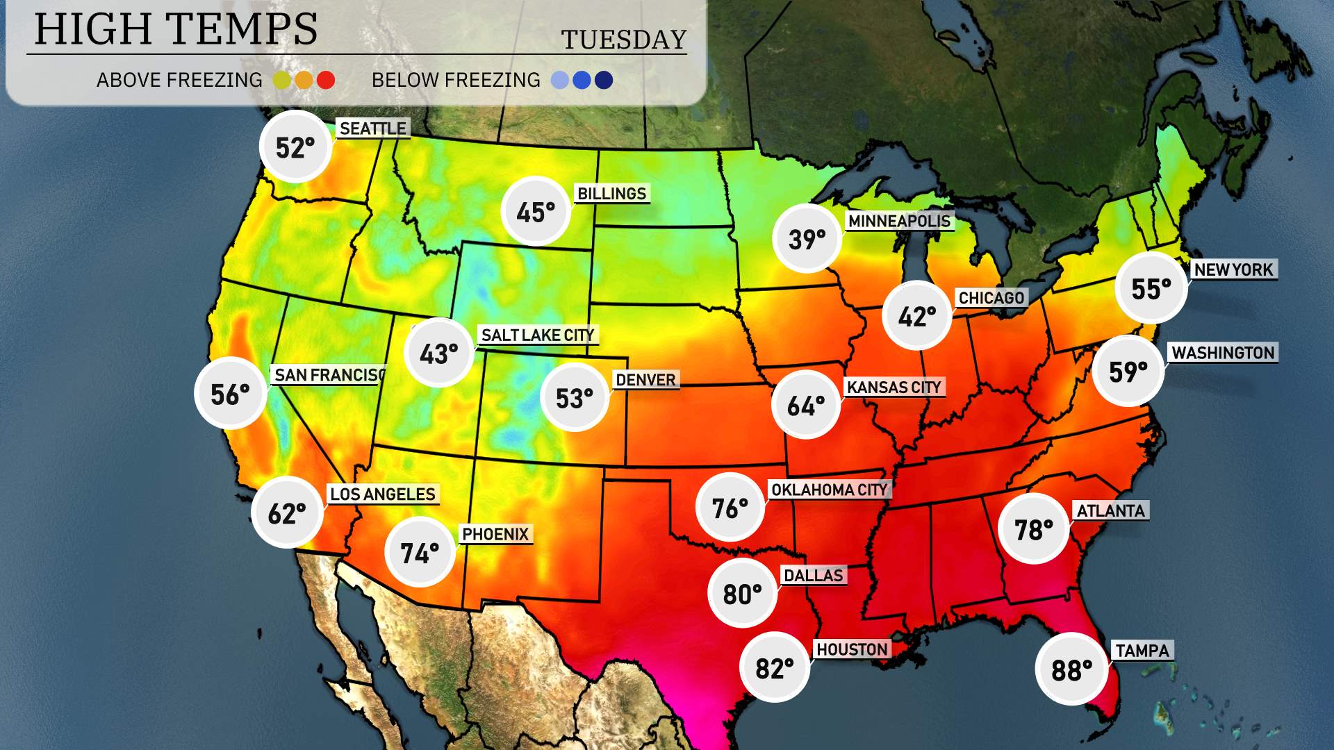
Today’s high temperatures are showcasing some interesting contrasts across the nation. In the South, Tampa sizzles with a warm 88 degrees, making it the hottest spot in the region. Atlanta is right behind at 78 degrees, while New Orleans enjoys a pleasant 77 degrees.
Moving to the Central Plains, Dallas reaches a comfortable high of 80 degrees, but just north in Kansas City, temperatures are much cooler at 64 degrees. Over in Oklahoma City, the mercury hits 76 degrees, reflecting mild and enjoyable conditions.
On the West Coast, Los Angeles is sitting at a mild 62 degrees, while Phoenix is warmer at 74 degrees, although still below the highs we typically see this time of year. It’s a chilly 43 degrees in Salt Lake City.
In the Northeast, New York lags behind with a high of only 55 degrees, while Washington, D.C. feels a bit warmer at 59 degrees. The Midwest remains cool, with Minneapolis peaking at a chilly 39 degrees, making it one of the colder spots today.
Now for the low temperatures. A chilly start is expected for the Northern Plains, with Billings at 30 degrees and Minneapolis dipping to 33 degrees. Denver will be particularly brisk, starting off at a frigid 29 degrees.
Moving to the Midwest, Chicago will see a low of 46 degrees, while further south, Kansas City is at 47 degrees.
In the Southern U.S., expect warmer conditions, with Dallas waking up to 60 degrees and Oklahoma City at 53 degrees. However, temperatures will still be cool in Houston, with a morning low of 75 degrees.
Out West, San Francisco will start at 45 degrees.
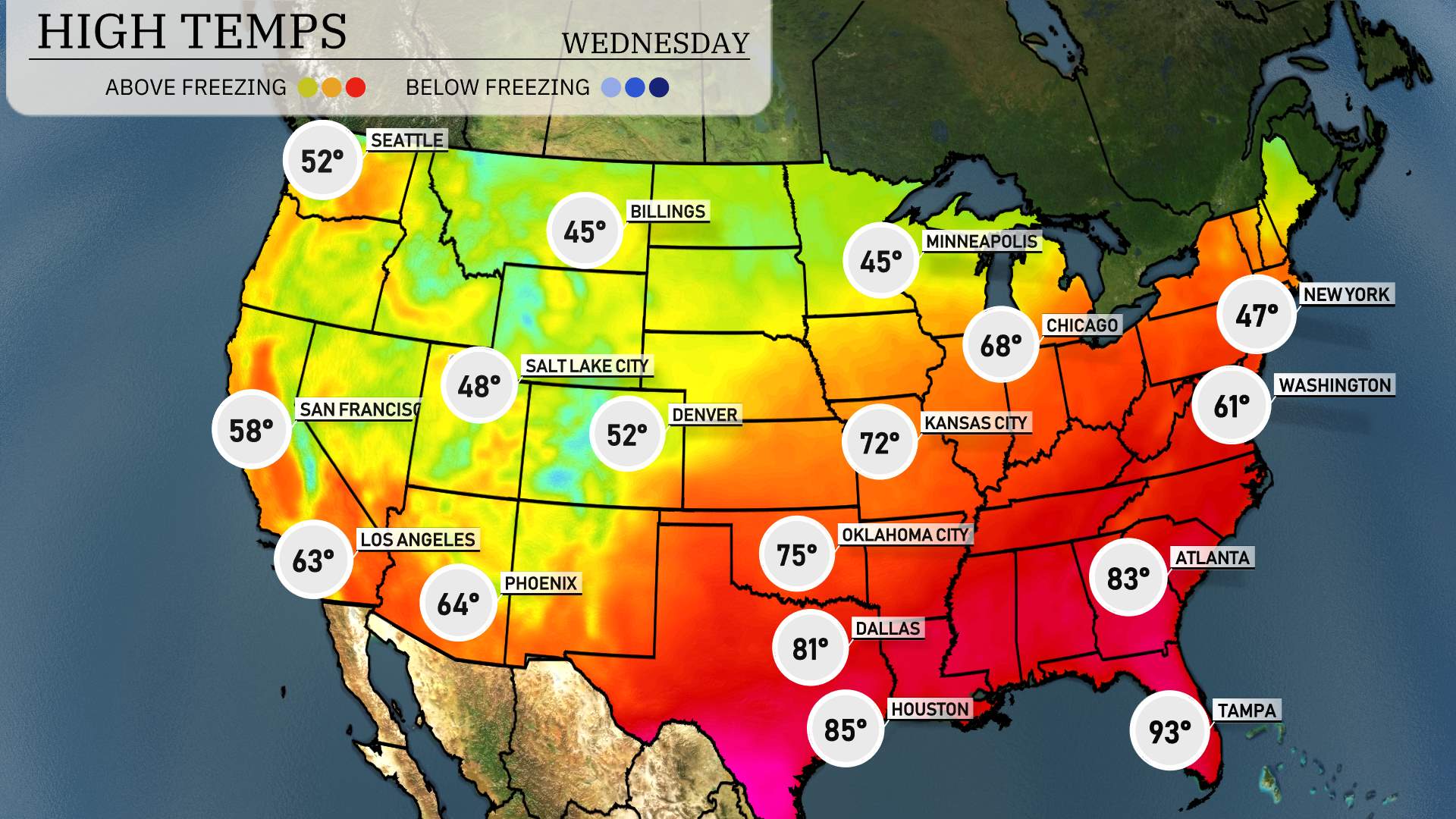
Tomorrow’s high temperatures across the Southwest region are trending above average as a ridge of high pressure settles in.
In Los Angeles, expect a pleasant 63 degrees, while San Diego will see a high of 58 degrees. Moving inland, Phoenix is forecasted to reach 64 degrees, making for a warm day out east.
Las Vegas is set to sizzle with a high of 71 degrees.
As we move further east, Dallas will reach a warm 81 degrees, with Austin hitting 82. Down in Houston, the mercury will rise to a balmy 85 degrees.
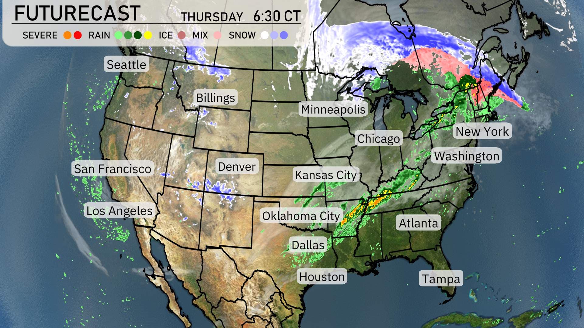
A distinct cold front sweeps through the Midwest, bringing a swath of rain and embedded thunderstorms from Chicago to Kansas City today. Strong winds could accompany these storms, so be mindful of gusty conditions. By tomorrow, the system advances into the Eastern Seaboard, impacting cities like New York and Washington with rain showers and possible thunderstorms–stay alert for any severe weather warnings.
In the Southeast, expect rain showers to continue from Dallas to Tampa. While severe weather isn’t as prominent, keep an eye on local updates as storms may bring brief gusty winds.
Up North, cooler air masses follow behind the departing system. Minneapolis and Denver will experience a drop in temperatures, reminding us of spring’s cooler side.
For the West Coast, California enjoys clear skies, particularly in the southern parts, after some morning fog lifts in San Francisco and Los Angeles. Enjoy the mild and sunny conditions!
In the Pacific Northwest, a mix of rain and snow lingers around Seattle and into the Northern Rockies, providing a wintry mix above 5,000 feet–prepare for slick roads if traveling through mountain passes like Snoqualmie.