Dive into a detailed weather forecast for the Southern Plains, with a focus on Austin. From severe storms to calm conditions, Meteorologist Amy Freeze guides you through the upcoming weather patterns.
Catch the latest weather updates for the Southern Plains on our blog. Amy Freeze provides expert insights on what to expect in Austin and surrounding areas.
As the skies over Austin show signs of changing, Meteorologist Amy Freeze delves into a detailed analysis for the Southern Plains region. From severe storms to gentle breezes, understand what these weather changes mean for your week ahead. Explore temperature variations, storm predictions, and safety tips on how to cope with extreme UV indexes. Everything you need to stay safe and informed, curated by Amy Freeze. Read more on our detailed blog at https://amyfreeze.ai/.
A line of severe storms, marked in bright colors on the radar, is tracking eastward through the Gulf Coast, currently impacting areas from Jackson to New Orleans. Heavy rain and thunderstorms are sweeping through these regions, possibly causing localized flooding. Scattered rain showers extend from Corpus Christi to San Antonio, with moderate precipitation observed. The rest of the Southern Plains, including Dallas, Oklahoma City, and areas westward toward El Paso, appear dry as clear skies dominate. Cloud cover increases slightly in the Little Rock area, but conditions there remain relatively calm as the severe weather stays farther south and east.
Austin’s evening hours bring partly cloudy skies, with temperatures starting at 83 degrees at 9 PM. An east-northeast wind blows at 6 miles per hour, offering a gentle breeze. Moving into late evening, temperatures dip to 77 degrees by 1 AM as cloud cover increases. Expect mostly cloudy conditions by 11 PM with a continued light breeze from the northeast at 4 miles per hour.
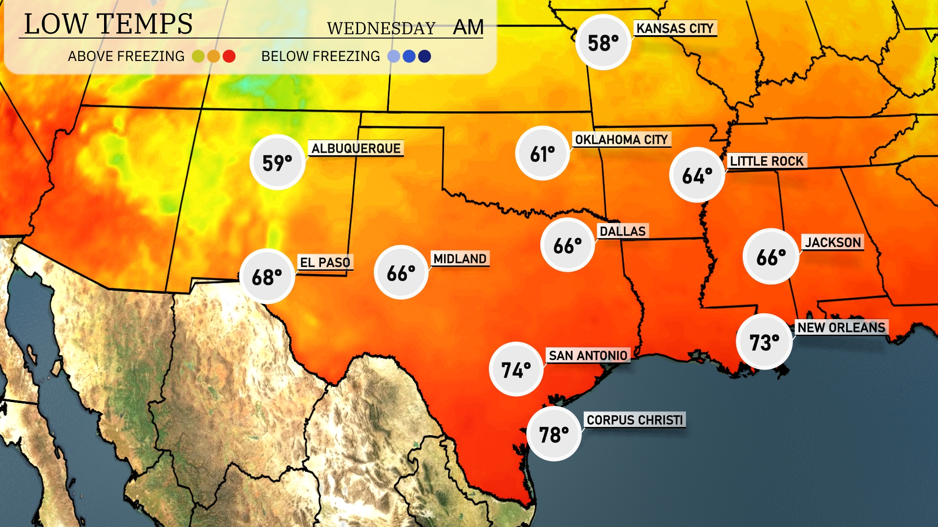
Tonight in the Southern Plains, temperatures are expected to dip significantly. Oklahoma City will see a low of 61 degrees, while Dallas will rest at 66. Midland is forecasted to drop to 66 degrees. San Antonio will remain on the warmer side with a low of 74, and farther south, Corpus Christi is expected to be quite mild at 78 degrees.
High temperatures for tomorrow in the Southern Plains are expected to be above average, with El Paso soaring to a warm 94 degrees. Midland will experience a pleasant high of 88 degrees. In San Antonio, temperatures will also reach 88 degrees, while Corpus Christi matches that at 88 degrees as well. Dallas is forecasted for a high of 80 degrees, making it quite comfortable. Oklahoma City will see a high of 78 degrees, contributing to a generally warm pattern across the region.
A dynamic weather pattern is setting up across the Southern Plains, with rain continuing from Dallas to Corpus Christi, bringing much-needed moisture. Oklahoma City is under the threat of stronger storms as an unstable air mass interacts with an approaching cold frontal boundary. Be prepared for potential severe weather warnings, especially across Southeast Texas, through Wednesday night. Temperatures ahead of the front remain warm, cooling slightly post-frontal passage by Wednesday afternoon.
The UV index in Austin is expected to be extreme at 10 for both Tuesday and Wednesday. With a burn time of just 12 minutes, it’s crucial to use high SPF sunscreen and seek shade during peak hours.
For the 7 day outlook in Austin:
Tuesday: Expect late thunderstorms with a high of 87 degrees and a low of 70.
Wednesday: Temperatures cool slightly to a high of 85 degrees under mostly cloudy skies, with a low of 71.
Thursday: Isolated thunderstorms develop, bringing the temperature up to 90 degrees, dipping to 70 overnight.
Friday: Mostly cloudy conditions with a daytime high of 85 degrees and a low of 68.
Saturday: The sun peeks through with partly cloudy skies, as temperatures reach a high of 88 degrees and a low of 72.
Sunday: Mostly clear skies return, warming up to 92 degrees with a low of 75.
Monday: Partly cloudy, rounding off the week with a high of 93 degrees and a low of 76.