Storm Watch: Navigating Memorial Day’s Severe Weather Across America
By
Amy Freeze
Meteorologist Amy Freeze guides you through potential flooding, severe storms, and unexpected heat waves this Memorial Day weekend.
Facing a stormy Memorial Day? Amy Freeze provides all the weather updates you need to make safe and informed decisions, from potential flooding in the South to record highs in the Southwest.
This Memorial Day, parts of the US face diverse weather challenges. The South and Ozarks brace for severe storms and flooding, while the central Plains enjoy a brief dry spell. In the Southwest, temperatures reach new highs, testing the limits of holiday celebrations. Keep an eye on these changes and adapt your plans accordingly. Remember, safety comes first! Full forecast at https://amyfreeze.ai/
Flooding and severe storms threaten those across the South and into the Ozarks over the long weekend.
The Southeast shows scattered rain near Atlanta and heavier showers approaching Tampa, suggesting travel delays. Lastly, Houston and Dallas remain dry currently, but conditions may change as systems evolve.
Attention shifts to the Midwest, where Minneapolis is under light rain moving eastward towards the Great Lakes. As we move into the central Plains, Kansas City appears dry, offering a brief respite.
Seattle experiences ongoing rain, providing much-needed moisture, while drier conditions emerge for San Francisco and Los Angeles. Across the Rockies, Billings and Denver see rain.
Temperatures sizzle in Phoenix at a high of 104 degrees, making it the standout for the Southwest. Over in Dallas, temperatures reach 92, while Houston sits slightly cooler at 90. The Southeast sees higher marks as well, with Atlanta warming up to 81 degrees, and Tampa hitting a steamy 94. The Northeast remains mild; New York and Washington, D.C. experience highs of 65 and 67, respectively.
For the low temperatures, Minneapolis dropping to 40 degrees and Chicago a bit cooler at 46. Heading to the Northeast, New York will see a morning low of 54 degrees, while Washington, D.C. comes in at a mild 51. Out West, Billings wakes up to a brisk 45 degrees, while Salt Lake City starts the day at 51. The South remains warm, with Dallas and Houston seeing comfortable lows of 75 and 79 degrees.
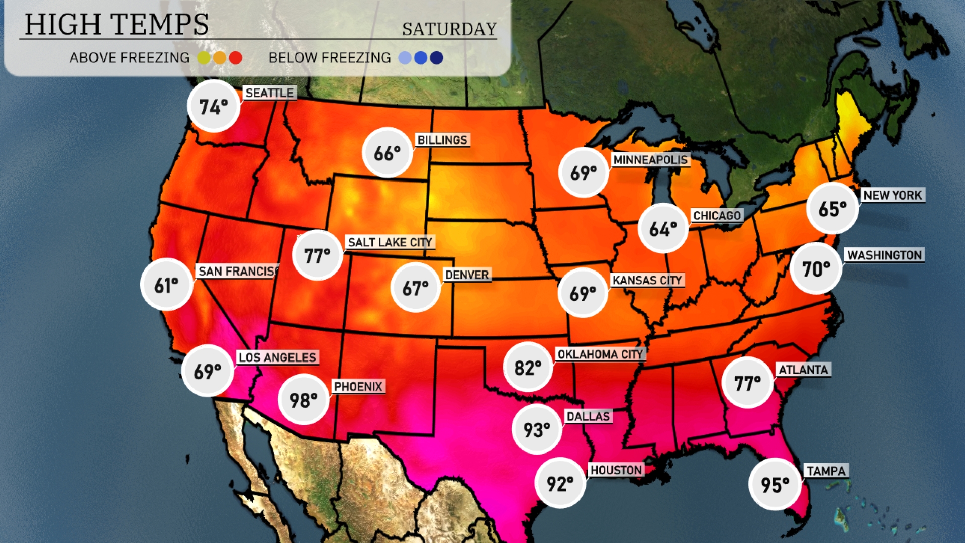
Tomorrow Dallas will experience a warm 93 degrees, while Houston is close behind at 92. In Oklahoma City, expect a high of 82 degrees, indicating slightly above-average conditions. Atlanta is looking at a comfortable 77 degrees, seasonable for this time of year. To the west, Phoenix is heating up significantly with a high of 98 degrees, surpassing typical readings for late May. Coastal cities, like Tampa, will also see high humidity, pushing temperatures up to 95 degrees, making it feel even warmer.
The Southeast is bracing for an active weather pattern over the next 48 hours as a cold front moves in from the west. Expect strong thunderstorms with frequent lightning and gusty winds from New Orleans to Atlanta, persisting into tomorrow. This system continues into the Carolinas, enhancing the risk for severe weather, including hail and potential tornadoes, particularly in Georgia and Alabama. The Midwest remains under the influence of heavy rain, with Kansas City and Chicago seeing consistent precipitation that could lead to localized flooding. In the Northeast, rain showers extend from Washington D.C. to Maine, potentially affecting visibility and travel. Out West, a quiet weather scenario unfolds with the Pacific Coast remaining mostly dry. However, in the Northern Plains and Intermountain West, a mix of rain and snow is expected with temperatures dropping significantly. Keep an eye out for weather warnings as this dynamic system progresses eastward.