Weather Across America: A Panoramic View of Our Dynamic Climate
By
Amy Freeze
From snowy evenings in New York to sunny days in Los Angeles, explore how diverse weather patterns affect different parts of America.
Today, we journey across America’s vast weather landscape, from snow-covered cities to sunlit coasts. Join Amy Freeze as she breaks down the unique weather events impacting regions nationwide.
Greetings from Meteorologist Amy Freeze! In today’s sweeping overview of U.S. weather, we see contrasting climates that paint a unique portrait of America’s immense diversity. From the icy blasts in the rugged Northeast to the radiant warmth bathing the Western deserts, each region exhibits distinct meteorological characteristics. Navigate through our engaging narrative that brings you the highs and lows of today’s weather, forecasts for tomorrow, and a peek into future climatic scenarios across the continent.
On this national radar overview, moving from west to east, the Pacific Northwest is dealing with scattered rain showers particularly impacting Seattle, offering some moisture to the area. In California, conditions appear to be relatively clear, especially in coastal cities like San Francisco and Los Angeles.
Across the Intermountain West, the radar shows a more dynamic weather pattern. Light snowfall is occurring in the northern Rocky Mountains.
In the Central Plains and Midwest, cities such as Denver and Kansas City are experiencing clear skies, with a great Saturday ahead.
As we progress towards the Great Lakes and Northeastern regions, conditions become more intense. A winter weather system is impacting New York and the New England states, with substantial snow and mixed precipitation leading to hazardous travel conditions. This area is currently experiencing the biggest impact from precipitation, with New York City seeing showers.
The Southeast, including areas such as Atlanta and Tampa, is currently under calm and clear conditions. Keep an eye out as this could change with advancing fronts in the coming days.
Washington D.C. and the surrounding Mid-Atlantic region are experiencing the tail end of the storm system, transitioning towards clearer conditions as weather systems move northeastward.
Today’s high temperatures across America show some interesting contrasts. In the Northwest, Seattle is a cool 53 degrees, while just to the south, San Francisco warms up to a comfortable 63. Over in the Rockies, Denver heats up to a scorching 87 degrees, significantly warmer than Salt Lake City, which reaches 74.
Heading into the central plains, Kansas City sees a high of 78, while neighboring Oklahoma City matches that at 85 degrees. Dallas and Houston are also feeling the warmth, both reaching 86 and 85 degrees, respectively.
On the West Coast, Los Angeles sits at a mild 66 degrees, but in stark contrast, Phoenix is blazing with a high of 100 degrees. Nashville experiences a mild day with a high of 70, and even cooler temperatures persist in the Northeast where New York struggles to reach 42 degrees.
Looking ahead to tomorrow morning’s low temperatures across the U.S., expect a chilly start in many areas.
In the Northeast, Boston will see a low of 40 degrees, while New York drops to 45. Washington, D.C. experiences a low of 48 degrees.
Moving into the Midwest, Chicago is looking at 53 degrees, while Minneapolis cools down to 43.
In the Northern Plains, Billings hits a frosty 31 degrees, with Denver slightly warmer at 37 degrees.
Heading west, Salt Lake City will see a low of 38 degrees, while in the southwestern U.S., Los Angeles remains mild at 52. Ely registers a low of 34 degrees.
Down south, Dallas has a comfortable start at 64 degrees, while Miami begins much warmer at 63 degrees.
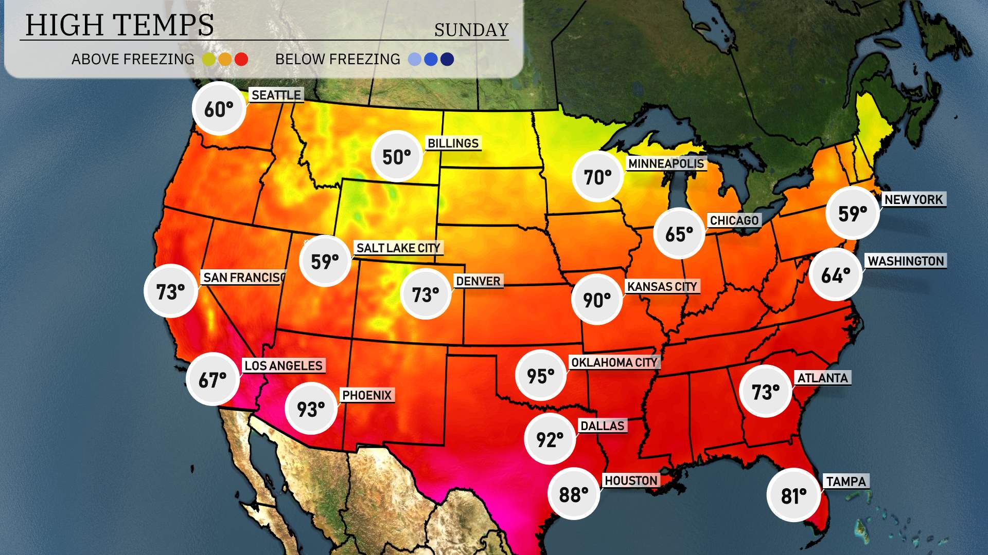
High temperatures for tomorrow across the region are shaping up to be significantly above average as warm air dominates. In Las Vegas, expect a toasty high of 93 degrees, while Phoenix will really feel the heat with highs reaching 95 degrees.
Shifting to California, Los Angeles is forecasted to hit 67 degrees, and San Francisco will see a pleasant high of 73 degrees. As we move north, Denver should experience a high of 73 degrees, with Salt Lake City slightly cooler at 59 degrees.
Farther inland in Wyoming, temperatures will remain mild with highs around 60 degrees
On the upcoming national futurecast, a significant cold front impacting the Midwest, moving into the Ohio Valley. Expect widespread rain and potential thunderstorms across cities like Chicago and Indianapolis. As the system advances, cooler air will replace warmer conditions, with temperatures dropping notably behind the front.
In the Northeast, storm systems bring mixed precipitation, including rain and snow. Cities like New York and Boston should prepare for slick roads and potential travel delays, especially during commuting hours.
Across the Great Plains, areas from Minneapolis to Kansas City will experience predominantly dry conditions with gusty winds, signaling swift weather shifts and the cooler air mass in transit from the north.
The Pacific Northwest anticipates an active weather pattern, with Seattle likely to experience persistent rain showers, while higher elevations get snow, impacting travel through mountain passes.
The Southwest, particularly around Los Angeles and Phoenix, will enjoy predominantly clear skies, with a largely stable and warm weather pattern, offering a respite from the wet conditions elsewhere.
The Gulf Coast, covering cities like Houston and New Orleans, sees a mix of cloud cover and sunshine, with minimal precipitation expected. Areas to the east, such as Atlanta and Tampa, should remain vigilant for isolated showers and thunderstorms developing through the day.