From Storms to Sunshine: A Detailed Coast-to-Coast US Weather Overview
By
Amy Freeze
Explore the stark weather contrasts across the US today, from stormy showers to sunny skies - a comprehensive analysis by Amy Freeze.
Today’s US weather features an array of conditions: tropical storm remnants in the Southeast, snow in the Rockies, and unseasonable heat in the Southwest. Dive into our detailed report for more!
Meteorologist Amy Freeze brings you an in-depth look at today’s US weather picture. From heavy rains and potential flooding in the Southeast to clear skies and seasonal warmth in the Southwest, get prepared with our comprehensive forecast and expert tips on how to handle diverse weather scenarios. Check out the full detailed analysis on our blog.
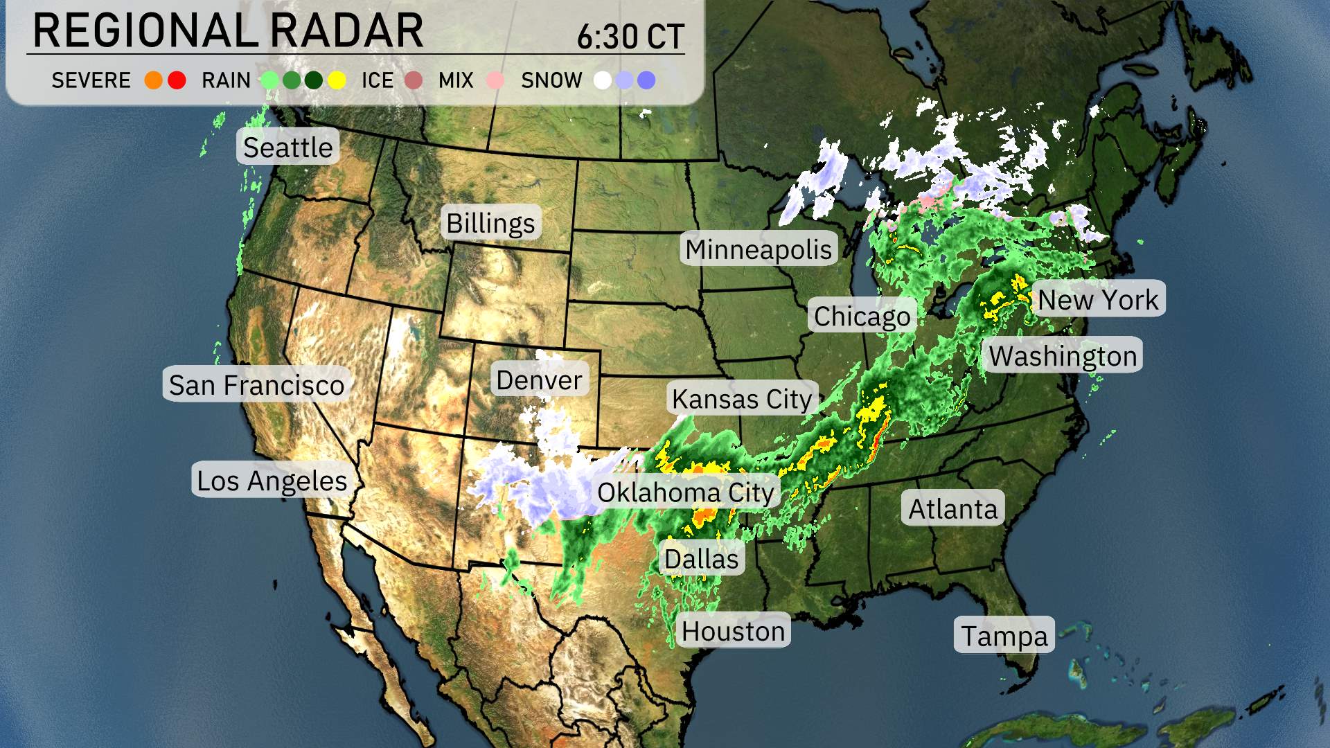
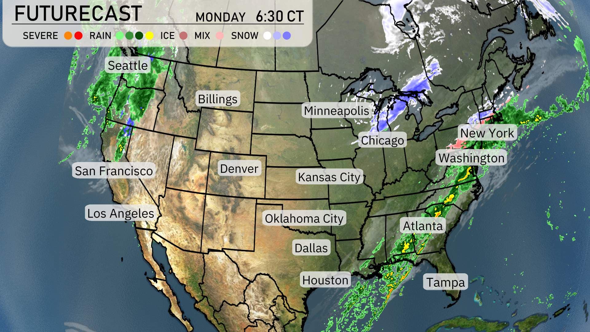
On the radar, the nation is experiencing a mix of winter and spring weather from west to east. The Pacific Northwest, around Seattle, remains relatively clear with minimal weather activity. Moving into the Rockies, places like Billings and Denver are witnessing snow showers. Particularly dense bands of snow are impacting the area around Denver, where travelers may experience delays.
Farther east, a significant weather system brings rain and severe storms stretching from Oklahoma City down towards Dallas. These storms are intense, with Oklahoma City experiencing some of the heaviest rains, which could result in local flooding.
As this line of storms moves eastward, it continues to impact regions like Kansas City and into the Upper Midwest towards Chicago. These areas should prepare for thunderstorms and the possibility of strong winds.
The heaviest impact today is in the central and eastern United States. The severe weather line extends from the Gulf northward towards Minneapolis and Chicago, bringing heavy rain. In particular, areas around Chicago and Indianapolis are under the threat of potentially severe storms.
Heading further east, rain is spreading into the Great Lakes, with cities like Minneapolis and New York witnessing consistent rainfall. The Mid-Atlantic region, including Washington D.C., is bracing for rain later today.
Cities like Atlanta and Tampa are seeing scattered showers, with more intense precipitation expected to develop as the system moves further east. Skies begin to clear as we look towards the Northeast and New England by tomorrow with only cloudy skies for now.
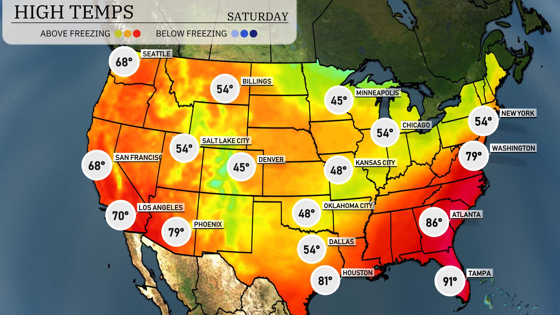
In the Southeast, it’s heating up with Atlanta reaching a balmy 86 degrees, making it one of the warmest cities in the region. Just south, Tampa sizzles at 91 degrees. Meanwhile, over in New Orleans, it’s a bit cooler with a high of 79.
Moving to the Central Plains, we see a significant contrast. Dallas is enjoying a pleasant 54 degrees, while Kansas City is even chillier at 48. Further north, Chicago registers 54 as well.
Out west, Los Angeles hits a comfortable 70 degrees, but things are a bit warmer in Phoenix where highs reach up to 79 degrees.
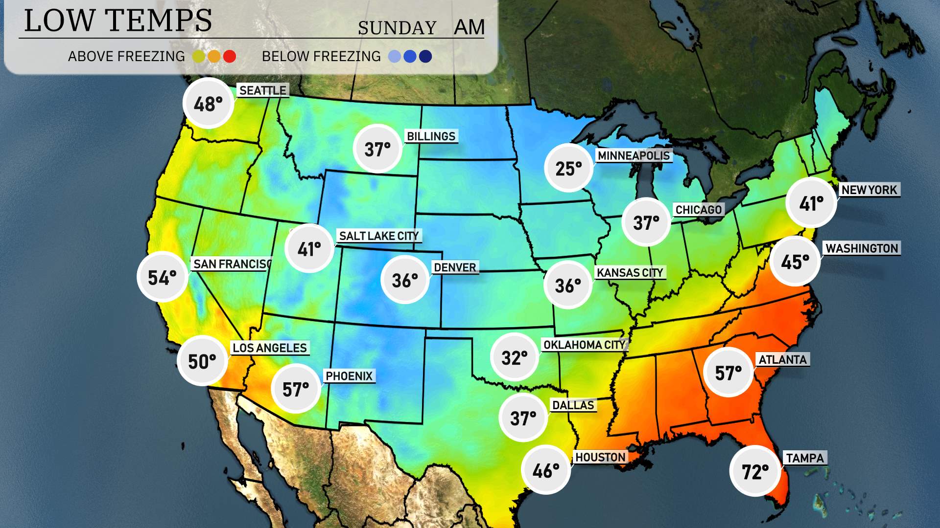
In the Midwest, Minneapolis shivers down to 25 degrees, with Chicago at a brisk 37. Heading further south, Kansas City is forecasted to dip to 36 degrees.
The Northeast sees cooler temperatures as well, with New York at 41 degrees and Washington, D.C. hitting a low of 45 degrees.
Traveling out west, Salt Lake City can expect 41 degrees, while Denver cools to 36. In Nevada, Ely will be hovering right at 32 degrees. Los Angeles stays mild at 50, and San Francisco will be at 54 degrees.
In the South, Dallas will have a low of 37 degrees, while Houston is a bit warmer at 46 degrees. Keep those jackets handy!
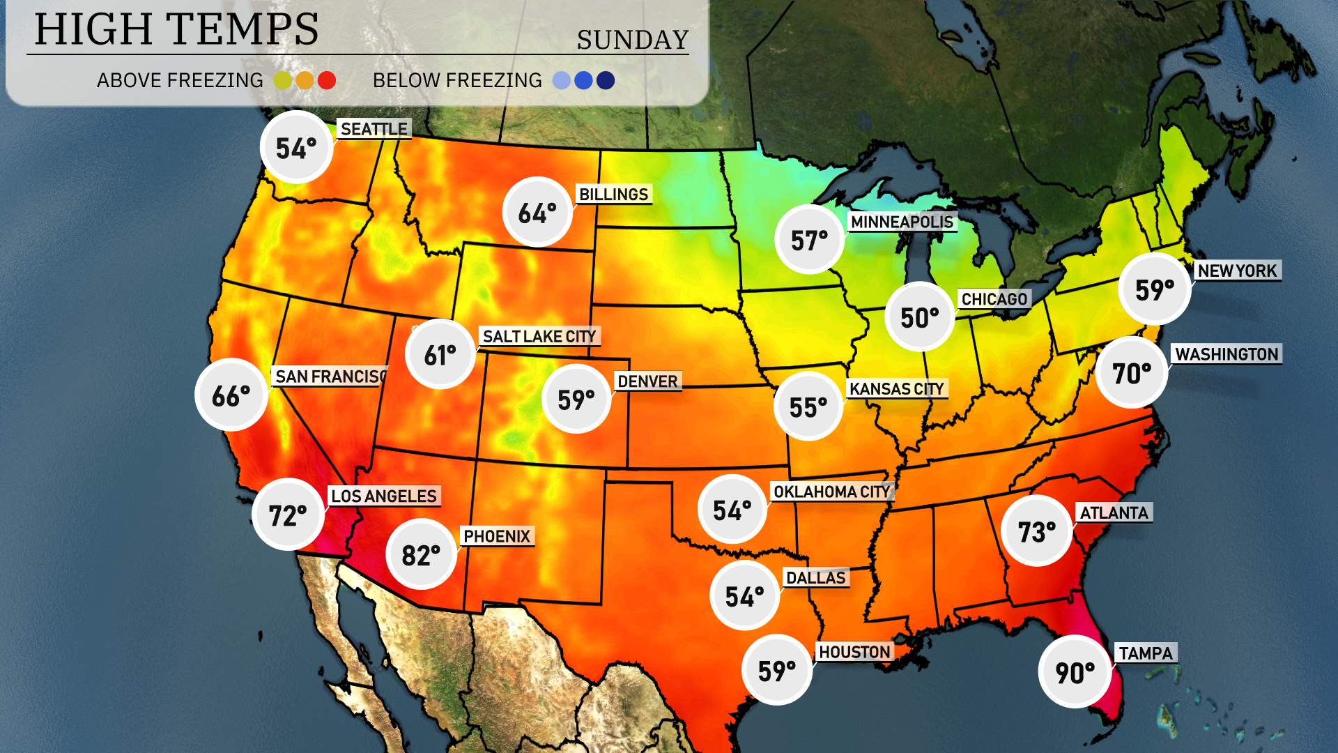
High temperatures are shaping up for tomorrow across the Southwest region. Expect a pleasant day in San Diego with highs around 66 degrees. Meanwhile, Los Angeles will warm up to about 72 degrees. In Phoenix, temperatures will peak at a balmy 82 degrees, showcasing a nice warming trend.
As we move further north, Salt Lake City hits 61 degrees, while Denver will see highs around 59 degrees. In the eastern part of the region, Dallas is looking at a cooler high of 54 degrees, which is below average for this time of year. Houston will see slightly warmer conditions with a high of 59 degrees.
The Southwest region will experience a mix of comfortable and slightly cooler temperatures, influenced by a sprawling high-pressure system that continues to dominate the area.
In the Pacific Northwest, expect continued rain as a moisture-laden front impacts Seattle and further into the Cascades. Keep an eye out for brief downpours and potential localized flooding, especially in low-lying areas.
Heading into the Midwest, the futurecast shows light snow showers over the Great Lakes region, particularly affecting Chicago and Minneapolis with light accumulations expected. Watch for slick conditions as the system moves eastward.
Across the East Coast, a front will generate rain bands stretching from Washington to New York. The system will progress towards New England, bringing wet and windy conditions. Travel may be impacted, so stay updated with local advisories.
In the Southern Plains, relatively mild conditions prevail with Dallas and Oklahoma City experiencing dry weather.