Coast to Coast Weather Wonders with Amy Freeze: A Stormy and Scenic U.S. Overview
By
Amy Freeze
Delve into this coast-to-coast weather overview presented by Amy Freeze. From storm surges on the West Coast to serene conditions in the Southeast, understand what’s happening in your region now.
Amy Freeze presents a dynamic weather review affecting different U.S. regions. Keep up-to-date with regional forecasts, temperature highs, and potential weather threats. Stay weather-aware!
Join Amy Freeze as she navigates through the varied weather landscapes affecting the United States. From severe storms in the Midwest to unexpected warm temperatures in Dallas, this comprehensive guide provides all the insight you need. With deeper analyses of high and low temperatures across regions and a peek into upcoming weather changes, equip yourself to face the weather with confidence.
There will be severe weather in the Midwest and Midsouth today. Go to your local forecast for more on the Level 3 enahanced risk from the Storm Prediction Center. Be weather aware today across Illinois, Indiana, Kentucky, Tennesee, Arkansas, Louisiana. The threats continues east tomorrow.
On the National Radar, we’re seeing activity across multiple regions. Starting in the west, rain is spreading into San Francisco and showers are impacting Los Angeles as well. Snow is falling in the higher elevations around Denver, which could influence mountain travel across Colorado.
The Midwest, including Kansas City, is experiencing a mix of rain and wet snow, while Minneapolis is dealing with focused bands of snow. Meanwhile, the southern Great Plains have calmed down with Dallas and Oklahoma City staying relatively dry.
Moving eastward, a significant weather system is bringing heavy precipitation and complex weather patterns to the Northeast. Chicago is seeing snow, transitioning to a mix and rain as you head further east. The biggest impact is around New York City, where rain dominates but mixed precipitation is possible in the suburbs.
In the Southeast, rain is widespread across Atlanta, extending toward Washington D.C. Heavier rainfall is affecting areas like Baltimore, which could lead to localized flooding. The mild conditions in Tampa are likely to persist as the rain remains to the north.
Today’s high temperatures showcase a mix of warm and cooler conditions across the nation. In the Midwest, Chicago is feeling mild with a high of 69 degrees, while Minneapolis remains on the cooler end at only 34 degrees.
Heading south, Dallas sizzles with a high of 88 degrees, making it one of the hottest spots in the region. Oklahoma City is warmer as well, at 82 degrees.
Moving eastward, the Southeast is enjoying pleasant temperatures, with Atlanta reaching 71 degrees. Washington, D.C. also enjoys a lovely day at 81 degrees, while New York experiences cooler conditions at 55 degrees.
Out west, Phoenix is quite warm with a high of 83 degrees, while Los Angeles and San Francisco are more comfortable around 61 degrees. The biggest contrasts today come from the Midwest’s chill against the warmth in Texas and Florida, where Tampa enjoys a high of 84 degrees.
Now for the low temperatures across the U.S. tomorrow morning. The Midwest is bracing for colder air, with Minneapolis dipping to 27 degrees, and Chicago reaching a low of 32—a chilly start at the freezing mark. Heading west, Billings will see a low of 33 degrees, while Salt Lake City drops to 35.
In the Southern Plains, Oklahoma City will start at 47, and Dallas is slightly warmer at 52. Moving southeast, Atlanta experiences a low of 47, while further south, Miami enjoys a milder 69 degrees.
High temperatures for the region tomorrow are showing a mix of above and below-average readings as we anticipate a shift in air patterns. In Denver, expect a high of 62 degrees, which is seasonal for this time of year. Moving south, Oklahoma City will reach a comfortable 63 degrees, while Dallas is warming up nicely to 70 degrees.
On the southern edge, Houston will enjoy a balmy high of 84 degrees, significantly above average, influenced by warmer air flowing in from the Gulf. Over in the eastern part of the region, Memphis is forecasted to reach only 49 degrees, feeling quite chilly compared to surrounding areas.
As we look west, Phoenix is expected to hit a high of 84 degrees, while Las Vegas will be slightly cooler at 74. Ely, Nevada, will have a forecast high of just 58 degrees, reflecting the cooler conditions moving through the area.
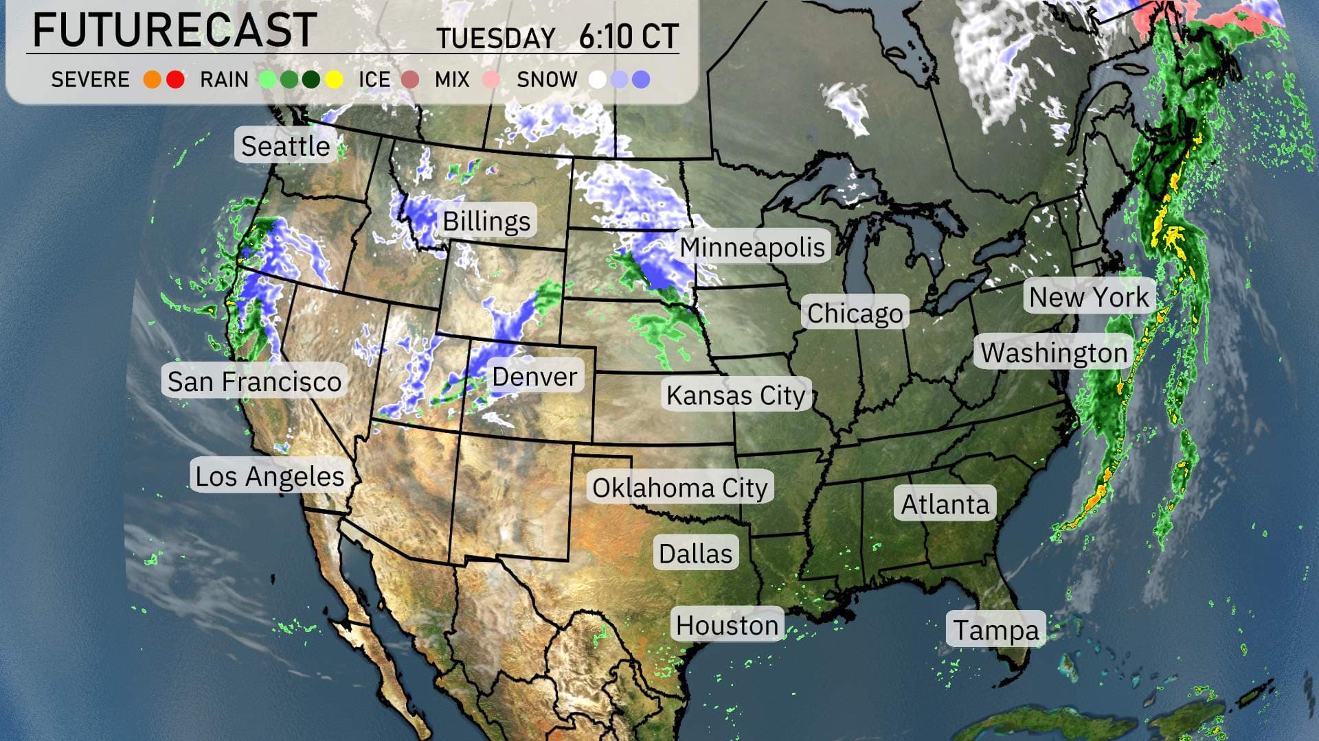
“On the futurecast, for planning into the weeke ahead. Get ready for a dynamic weather shift in the Pacific Northwest and Northern Plains. Seattle can expect rain showers tapering off by late Tuesday. Meanwhile, snow will make an impact across the Northern Rockies, affecting areas like Billings and Minneapolis with wintry travel conditions into Wednesday.
In the Central Plains, cloud cover dominates but with little precipitation expected. Cooler air filters in with highs dipping a bit below the norm from Denver to Kansas City.
Moving further east, New York and Washington are seeing rain clear by Tuesday evening. But hold onto your hats in the Great Lakes as the next system brings windy conditions with scattered rain for areas around Chicago.
The West Coast enjoys a break in severe weather, but San Francisco might see light rain as the week progresses. Overall, temperatures remain slightly on the cooler side, especially in the Northeast and Midwest, so light jackets might come in handy!”