Weather Whiplash: From Pacific Storms to Southeastern Sunshine
By
Amy Freeze
Explore the dynamic and contrasting weather patterns sweeping the U.S., led by renowned meteorologist Amy Freeze. Dive into details about the impact of these patterns on various regions.
Meteorologist Amy Freeze provides a compelling overview of today’s fluctuating weather across the U.S., from rain-drenched cities in the West to the clear, sunny South.
Meteorologist Amy Freeze provides a compelling overview of today’s fluctuating weather across the U.S., from rain-drenched cities in the West to the clear, sunny South.
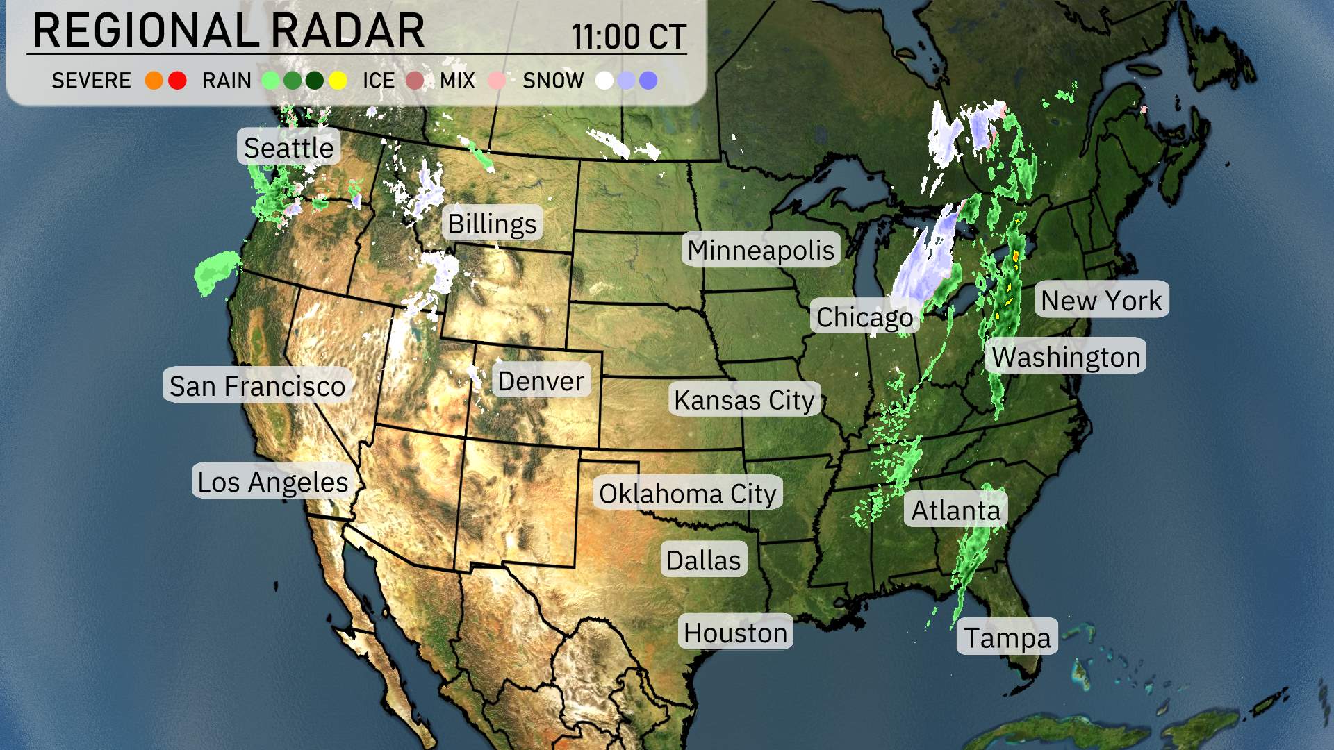
On the National Radar, starting from the west, Seattle is experiencing some rain showers, indicating a damp day ahead. Moving inland, areas around Billings are relatively clear, with no significant precipitation noted. Denver and Los Angeles are also quiet on the weather front, enjoying clear skies without any wet weather to disrupt the day.
Over in the Midwest, Minneapolis has dry conditions, but a light mix of snow is seen advancing towards Chicago, making it a wintry day there with a mix of rain and snow moving through. This layer of snow extends eastward through the Great Lakes region and towards the Northeast.
The most significant impact appears to be in the Northeast corridor. New York and Washington, D.C. are under a substantial band of precipitation, primarily rain and snow. Travelers and commuters in these areas should plan for possible delays and challenging road conditions.
Further south, Atlanta and Tampa are enjoying clearer weather, with no precipitation currently affecting these areas, allowing for uninterrupted outdoor activities. However, a close eye should be kept as weather systems often change rapidly during this time of year.
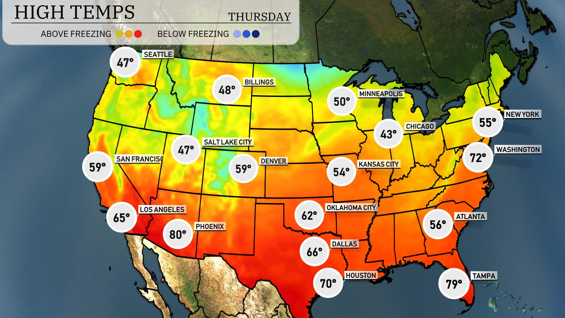
Today, we’re seeing some interesting temperature trends across the country. In the West, Los Angeles reaches a pleasant 65 degrees, while San Francisco is a bit cooler at 59. Over in Phoenix, it’s a warm 80 degrees, definitely the standout in the region.
As we move to the Central U.S., Kansas City is on the chilly side with a high of just 54 degrees, while Oklahoma City logs a slightly warmer 62 degrees. Heading into Texas, Dallas warms up to 66, and Houston sees a nice rise, topping out at 70 degrees.
In the Southeast, Atlanta is a bit cooler today at 56 degrees, but further south, Tampa shines bright at 79 degrees, making it one of the warmer spots. In the Mid-Atlantic, Washington, D.C. hits 72 degrees, while New York is on the cool side with a high of 55.
Overall, we’re seeing some notable contrasts today, especially in the Southwest and Southeast regions.
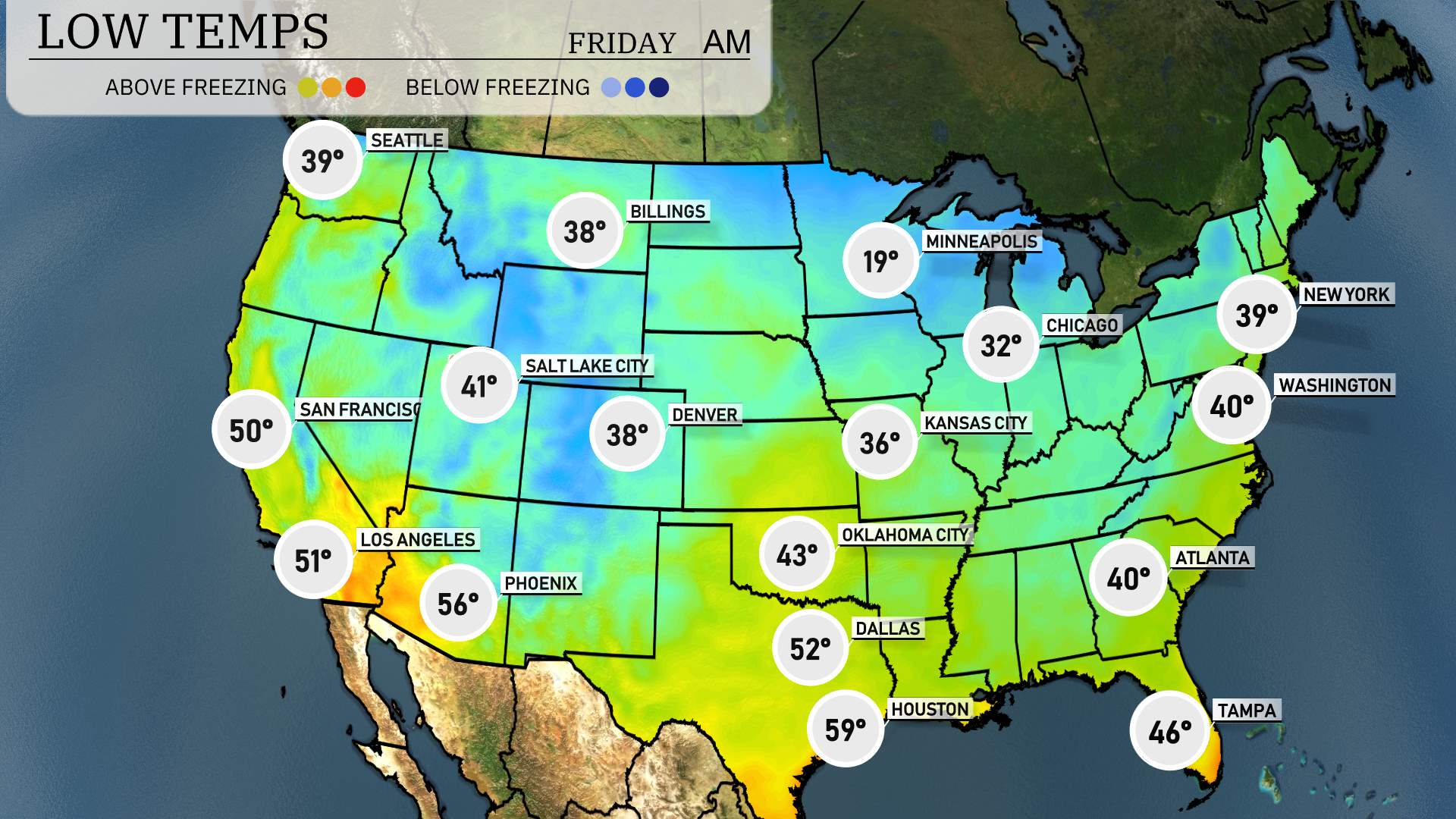
In the northern tier of the U.S., expect a chilly start with Minneapolis plunging to 19 degrees, a stark drop for the area. Chicago will see lows dipping to the freezing mark at 32 degrees, while Kansas City chills at 36 degrees.
Moving to the Midwest, Omaha registers a low of 30 degrees. Detroit will be slightly warmer with a low of 34 degrees.
Across the Rockies, Denver is waking up to 38 degrees, while Salt Lake City is at 41 degrees.
Down south, Dallas experiences a low of 52 degrees, and Houston stays milder at 59 degrees. Meanwhile, the Southeast sees temperatures dipping to 40 degrees in Atlanta and Washington, D.C. expect a low of 40 degrees too, while Tampa is cooler at 46 degrees.
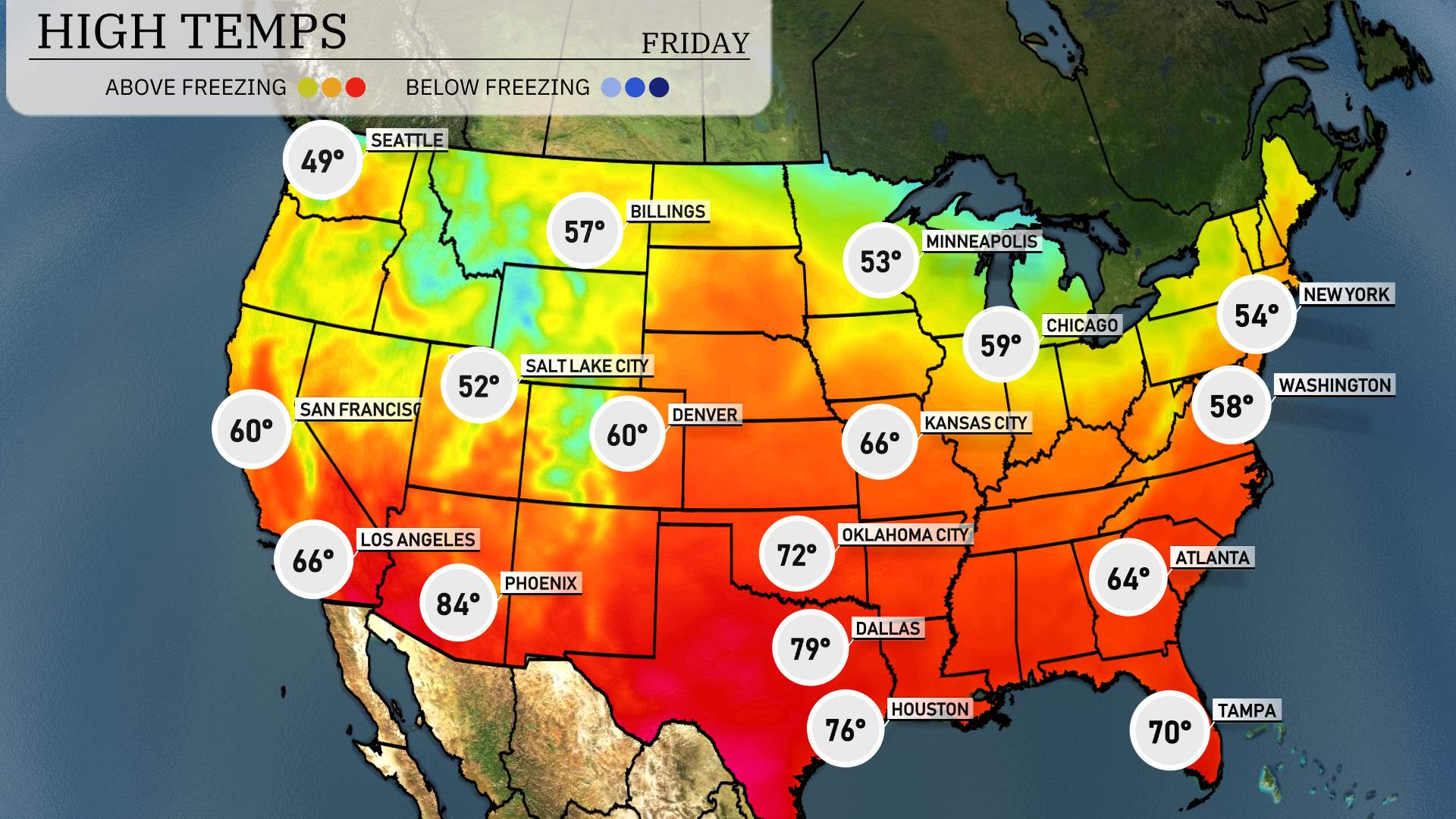
High temperatures for tomorrow across the West show some variability due to shifting weather patterns. In Nevada, Ely will see a high of 62 degrees, while Las Vegas warms up to a significant 84 degrees, which is notably above average for this time of year.
Moving towards California, Los Angeles will reach 66 degrees and San Francisco is expected to hit 60 degrees. Meanwhile, the Rocky Mountain region is experiencing a more moderate trend, with Denver expecting a high of 60 degrees.
In contrast, further north, Salt Lake City will see a slightly cooler afternoon with highs around 52 degrees. Overall, temperatures are trending warmer in the Southwest, particularly in southern Nevada and southern California, contrasting with cooler readings in parts of the Great Basin.
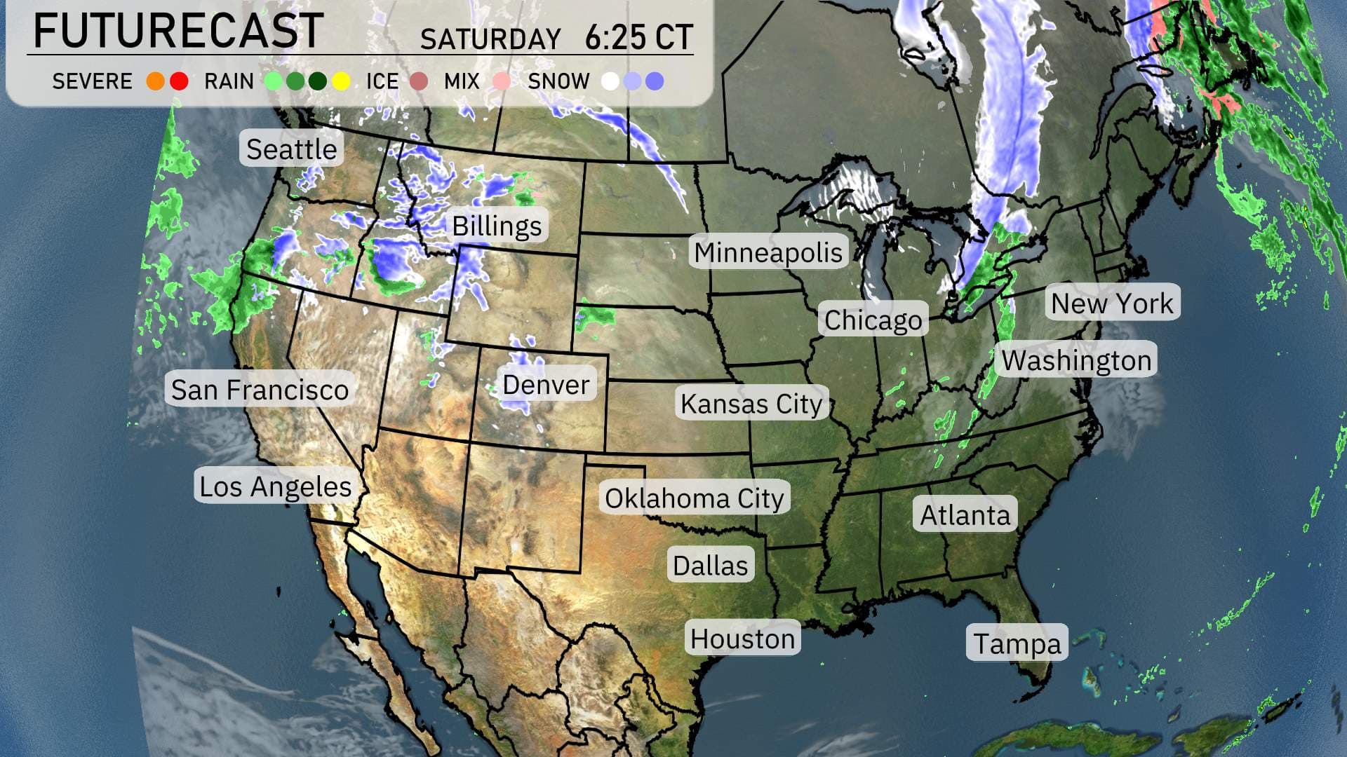
“A weather shift is unfolding across the Pacific Northwest and Northern Rockies. Expect rain and high-elevation snow showers affecting Seattle to Billings, potentially hindering travel in mountainous regions through Saturday evening.
In the Northeast, from New York City to Boston, spotty rain showers with a mix of snow are on the horizon, tapering off by Saturday night. No major accumulations expected, but slippery roads are still possible in higher elevations.
Meanwhile, the Southwest remains dry with mild temperatures, and across the Plains, conditions stay clear from Kansas City down to Dallas, promoting pleasant outdoor opportunities for the start of the weekend.
Looking at the Southeast, areas from Atlanta to Tampa will see scattered showers. Thunderstorms aren’t anticipated, but keep an umbrella handy as short, heavy downpours could disrupt afternoon plans. Weather conditions will be predominantly calm stretching into the weekend for the majority of the region.”